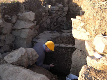
The Evaluation of a Multi-Period Prehistoric Site and Fogou at Boden Vean, St Anthony-in-Meneage, Cornwall
Charlie Johns, James Gossip, 2009. https://doi.org/10.5284/1000042. How to cite using this DOI
Data copyright © Cornwall Council unless otherwise stated
This work is licensed under the ADS Terms of Use and Access.
Primary contact
Charlie
Johns
Cornwall Council
Kennall Building, Old County Hall
Station Road
Truro
TR1 3AY
UK
Tel: 01872 322056
Resource identifiers
- ADS Collection: 927
- DOI:https://doi.org/10.5284/1000042
- How to cite using this DOI
Overview

A number of significant results have emerged from the project at Boden. Principal aims of the project were centred around the fogou, establishing its character and immediate and wider context. This has been achieved, with a much clearer plan of its extents, layout and structural form, and its context within a contemporary enclosure. Analysis of the in situ deposits at the base of the fogou have provided secure radiocarbon dates for the fogou, three of these from carbonised pottery residue, with construction dated to before 420-350 cal BC (94% probability).
Excavation of the fogou, the enclosure ditch and associated features within it produced an important and well dated assemblage of Later Early Iron Age pottery occurring in the fourth century BC.
Excavation of the Bronze Age structure in Trench 1 revealed sherds from a very remarkable Middle Bronze Age vessel, with no known comparanda in terms of size or decoration. Radiocarbon dates from residues on the pottery suggest that the vessel was last used 1400 - 1190 cal BC (95% probability) when it was deliberately broken and laid out the base of the structure, probably as part of a ritual act.
Post-Roman activity in the later fills of the enclosure ditch and internal features was also well represented by a distinctive assemblage of Gwithian Style ceramics representing at least 22 vessels, carbonised residues from which it have provided the first published dated assemblage of Gwithian style material, OxA-14560 cal AD 590 - 670 (95% probability).
Overall the evaluation trenches revealed evidence of intermittent activity starting in the Middle Bronze Age (c 1400 BC) and occurring again in the Later Early Iron Age (c 400 BC), the Romano-British period (first to second centuries AD), and finally in the sixth and seventh centuries AD. Flint which could be Neolithic in date (along with some pieces that are potentially Mesolithic in character), suggest that human presence on the hill may have occurred earlier probably in the northern part of the field. The geophysical survey of fields surrounding the site has revealed circular, oval and curvilinear anomalies suggesting that the excavated features represent only a small part of a complex, long-lived landscape which is likely to contain more extensive settlement from each of these periods.
Trench 1 revealed the western edge of a Bronze Age structure which despite the ritual nature of its closure, may have had a primary domestic function, although this cannot be verified. Environmental evidence in the form of cereals recovered from the structure supports the notion of a settled Bronze Age community and show that ground was being cultivated, with wheat and barley were being consumed at this time.
The rectangular enclosure, principal internal features and fogou were constructed during the Later Early Iron Age, probably around 400BC. Structural evidence for domestic occupation was not identified by the excavation, although postholes, surfaces and deposits containing discarded refuse suggests that occupation was settled during this period. Construction of the fogou and the enclosure must have been a major undertaking and suggests a level of special status and/or function, structures which must surely have been used by a well established community. Plant macrofossil and charcoal evidence shows that a cereal crop regime (spelt wheat) was in place at this time and that there had been significant clearance of woodland to allow field systems to be established. It is likely that a number of functions were served by the enclosure and what would have been a substantial bank or rampart. Whilst the physical characteristics of the ditch and rampart would have provided protection for the community, its livestock and other valued commodities, the appearance and nature of the enclosure in a symbolic sense may have been just as vital.
Use of the enclosure, but not the fogou, continues during the early centuries of the first millennium AD, although the intensity of activity is less clear. Romano-British pottery from the later fills of the enclosure ditch show this to have silted substantially by this time, although it was clearly still in use. A ditch excavated in trench 1 represents part of a field system in use at this time and produced Cordoned Ware pottery from this period; the geophysical survey anomaly suggests that this field plot may have been attached to the north-western corner of the enclosure. The extensive linear and curvilinear ditch anomalies evident from geophysical survey and an apparent oval structure with which they could be associated suggest extensive use of the surrounding landscape and perhaps unenclosed settlement during this period. Pottery recovered from the 'well' or shaft show that the upper levels of this were being infilled between the second and third centuries AD. The investment of effort in the excavation of a shaft of this depth (and it may be considerably deeper that the level to which it has been excavated) suggests that substantial community was present on this land at the time.
Occupation and use of the site continued in the Post-Roman period (sixth and seventh centuries AD) and is represented by the extensive collection of Gwithian Style pottery.


