
Burdale: an Anglian settlement in the Yorkshire Wolds
Julian D Richards, Steve Roskams, 2013. https://doi.org/10.5284/1021540. How to cite using this DOI
Data copyright © Prof Julian D Richards unless otherwise stated
This work is licensed under a Creative Commons Attribution 4.0 International License.
Primary contact
Prof
Julian D
Richards
Department of Archaeology
University of York
King's Manor
Exhibition Square
York
YO1 7EP
England
Tel: 01904 433901
Fax: 01904 433902
Resource identifiers
- ADS Collection: 1596
- DOI:https://doi.org/10.5284/1021540
- How to cite using this DOI
Overview
Location
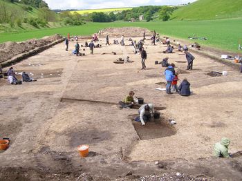
May 2006 excavations from the east
The valley floor today comprises a long narrow level field, approximately 1km in a north-west to south-east orientation with an average width of 120m. Steep sides rise upwards from the field boundaries. The western end is not far from the convergence of Fairy Dale and Middle Dale at Burdale Crossroads, while Whaydale joins the northern side, about 500m from the western end. The valley bottom has a very slight upwards slope away from the Fimber boundary towards Burdale Crossroads. A natural spring rises above Burdale Crossroads and today runs as a subsurface stream towards Fimber (Hayfield 1987). It feeds a pond which would have supplied both the settlement and animals in the surrounding pasture (Hayfield and Wagner 1995, 56). The Thixendale-Fimber road runs down the southern edge of the valley, alongside the 19th-century embankment for the Malton/Driffield railway. The railway cutting has significantly altered the topography and slope profile of the valley bottom. Lester Bell, tenant farmer, notes that the springs seen today at Fimber and Burdale Crossroads were once joined together by a stream that ran across the valley bottom. In the 1950s this watercourse dried up, but it can be clearly seen running across the field on the 1890 1:2500 Ordnance Survey map, and its course is also visible on the aerial photograph.
Previous work
The Burdale valley was included within Colin Hayfield's Wharram parish survey, and two sites were identified (Hayfield 1987, 132-44). The first (Burdale Crossroads â SE872623) was investigated on the triangular green formed by the road intersection at Burdale. A sequence of pottery spanning from the 3rd or 2nd century BC to the 17th century AD suggests this was a preferred settlement location, although there is no evidence to suggest it was permanently occupied (Hayfield 1987, 132-7) . A Roman and Anglo-Saxon site became the location of the medieval vill which, following its desertion in the 16th century, became the site of a large post-medieval farm, Burdale House Farm. The majority of this site is overlain by the railway embankment and present-day farm buildings.
Hayfield's second site (B18: Burdale/Fimber Boundary farmstead - SE 881618) is at the other end of the valley (Hayfield 1987, 137-43). Crop marks appeared here in 1976 and were photographed by Tony Pacitto. Hayfield recovered predominantly Roman sherds and concluded that this was another Romano-British farmstead. Given its location, 950m from the Burdale Crossroads site, he observed that it would comply with the general 1km spacing of Romano-British settlements in the Wharram area. It is likely that the current roadway follows the route of a Roman trackway (Hayfield 1987, 195).
The digital archive
The Burdale digital archive comprises a broad range of primary and secondary data derived from fieldwork and post-excavation analysis. It complements the summary report published as Richards and Roskams (2012). The file downloads are organised in 3 groups: those relating to the whole project and those specifically related to excavations in 2006 (BUR06) or 2007 (BUR07). The archive should be consulted in association with the data paper, published in Internet Archaeology.
Full stratigraphic reports are downloadable for each season of excavation and can be related to the sequence of CAD plans also available. These can, in turn, be set within the wider site map derived from aerial photography and geophysical survey. Final reports are available for the pottery, spindlewhorls, and worked bone and antler. Other finds are simply listed in the finds databases, split by excavation year, with some preliminary notes on the ironwork included in the investigative conservation reports. The non-ferrous finds assemblage was largely missing, apart from a small number of topsoil finds recovered during metal detector surveys. Given the alleged wealth of the site, and the interest in it from 'nighthawks' we have to assume that unfortunately, most of the coinage and copper allow metalwork has been collected from the ploughsoil over many years and is in private hands or has been sold for profit. In common with other Yorkshire sites Burdale produced very little early medieval pottery but this is likely to be a real absence rather than a product of recovery bias. The animal bone assemblage is one of the most important elements of the archive. Richardson has published a summary report and comparison with the Wharram Percy assemblage in Wharram XIII but her full report on the Burdale assemblage is available here, along with the database of faunal remains, available for download.
Over 300 images are also presented, split by year of excavation. In addition to a range of general site working shots to give the archive user an overall impression of the excavations, they include record shots of most features during or after excavation, searchable by context number. Finally, there are a number of record shots of selected finds, taken for the metal detector survey reports, or during conservation, and searchable by small find number.
The Burdale archive is offered as one of a growing number of archives of supplementary digital material for Anglian and Anglo-Scandinavian sites in East and North Yorkshire, available from the Archaeology Data Service. These include:
| Cottam A | doi:10.5284/1000132 |
| Cottam B (Burrow House Farm) | doi:10.5284/1000339 |
| Cowlam | doi:10.5284/1000175 |
| Wharram Percy | doi:10.5284/1000415 |
Acknowledgments
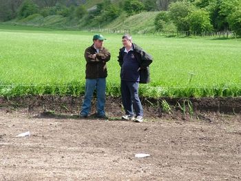
Julian Richards and metal detector user
Mark Ainsley in discussion
The fieldwork at Burdale was undertaken as part of University of York training. On-site direction was undertaken by Steve Roskams, with additional supervision by Madeleine Hummler, Steve Dobson and Ben Gourley. Initial interest in the site was prompted by Cath Neal's doctoral research. Metal detecting support was provided by Mark Ainsley, Geoff Bambrook, Ian Postlethwaite, and colleagues in Historia Detectum. Michael Charno, Eric Thurston and Thomas Mountain provided CAD support. Mags Felter and Ian Panter at York Archaeological Trust undertook the finds conservation, and Tony Austin and Elizabeth Jelley catalogued the finds. Eleanor Blakelock examined the ironwork, and Steve Ashby the bone and antlerwork. Permission to carry out the fieldwork was granted by Lester Bell, tenant farmer, and by the landowner, the Right Honourable Michael Willoughby (now Lord Middleton) and the Birdsall Estate Company.
Bibliography
Hayfield, C. 1987 An Archaeological Survey of the Parish of Wharram Percy, East Yorkshire. 1, The Evolution of the Roman Landscape, Br. Archaeol. Rep. Br. Ser. 172
Hayfield, C. and Wagner, P. 1995 'From Dolines to Dewponds: a study of water supplies on the Yorkshire Wolds', Landscape History 17, 49-64.
Stoertz, C. 1997 Ancient Landscapes of the Yorkshire Wolds, RCHME, Swindon.
