
Cobham Golf Course, Cobham, Kent - Integrated Site Report
Museum of London Archaeology, 2009. (updated 2017) https://doi.org/10.5284/1044804. How to cite using this DOI
Data copyright © High Speed 1 unless otherwise stated
This work is licensed under the ADS Terms of Use and Access.

Primary contact
Stuart
Foreman
Senior Project Manager
Oxford Archaeology (South)
Janus House
Osney Mead
Oxford
OX2 0ES
UK
Tel: 01865 263800
Fax: 01865 793496
Resource identifiers
- ADS Collection: 2377
- DOI:https://doi.org/10.5284/1044804
- How to cite using this DOI

Introduction
The Museum of London Archaeology Service (MoLAS) undertook a watching brief, and more detailed excavation at a number of sites of archaeological interest, on the section of the Channel Tunnel Rail Link (CTRL) between Scalers Hill and the A228, south of Gravesend, Gravesham District, Kent. The principal point of archaeological intervention was at Cobham Golf Course and this site name has been adopted to cover all of this section (Zone 5) of the route.
The several phases of prehistoric activity recorded at Cobham Golf Course will directly contribute to the further understanding of the Bronze Age archaeology of Kent. Residual flintwork and pottery indicate some Mesolithic and Neolithic settlement in the immediate area. However, most of the excavated evidence can be assigned to the Bronze Age (2150-700 cal BC). This activity consists of a ring ditch, perhaps belonging to an early Bronze Age round barrow, land divisions, a track or hollow way, and occupation deposits spanning the mid to late Bronze Age. The precise dating of the putative barrow remains uncertain but sherds of Collar Urn and Food Vessels from the ditch fill together with flintwork indicate that it may have been constructed and used in the early Bronze Age (2150-1600 cal BC), while late Bronze Age material from the upper ditch fill suggest some reuse or concern with appropriating an earlier monument.
An east-west aligned ditch (211) of middle Bronze Age date and a late Bronze Age hollow way appear to mark the northern boundary of a late Bronze Age settlement, dating perhaps to the 10th-9th centuries cal BC based on the style of pottery and a single radiocarbon determination. An area of occupation comprising a concentration of pits and postholes was divided by a north-south aligned ditch (133) of contemporaneous date. These features produced typical assemblages of broken pottery, perforated clay slabs, loomweights, worked and burnt flint, and charred plant remains. Animal bone was not preserved at this site and was therefore notably absent from these occupation deposits. The presence of briquetage within these features is less typical and its character is of exceptional interest within the context of the overall CTRL project. Only at Cobham does a high proportion of the briquetage have 'salt skin' present, indicating that this was either a site of salt production or was in close proximity to such a site.
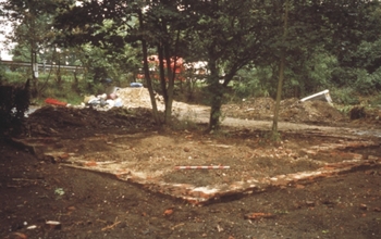
A number of post-medieval features dating to the late 18th and early 19th centuries were also recorded. The remains included an 18th-century well located at the western end of the zone, which has since been preserved in situ, a series of late 18th-century features associated with the landscaping of the Cobham Park Estate by Humphrey Repton and the brick foundation walls of a late 18th-century gatehouse to the estate.
The fieldwork events covered by this report are:
- Cobham Golf Course (ARC CGC98) - Excavation
- Brewer's Gate (ARC BG98) - Excavation
- Watling Street (ARC WS98) - Excavation
- Area 330 Watching Brief (ARC 33098) - Watching brief
