
East of Station Road/Church Lane, Smeeth, Kent - Post Excavation Assessment Report
Oxford Archaeology (South), 2009. (updated 2017) https://doi.org/10.5284/1044825. How to cite using this DOI
Data copyright © High Speed 1 unless otherwise stated
This work is licensed under the ADS Terms of Use and Access.

Primary contact
Stuart
Foreman
Senior Project Manager
Oxford Archaeology (South)
Janus House
Osney Mead
Oxford
OX2 0ES
UK
Tel: 01865 263800
Fax: 01865 793496
Resource identifiers
- ADS Collection: 2471
- DOI:https://doi.org/10.5284/1044825
- How to cite using this DOI

Introduction
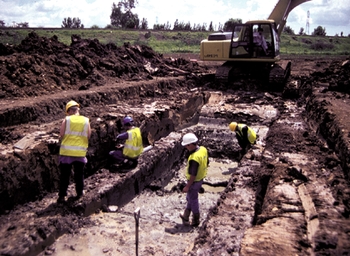
As part of an extensive programme of archaeological investigation carried out in advance of the construction of the Channel Tunnel Rail Link (CTRL), the Oxford Archaeological Unit was commissioned by Union Railways (South) Limited to undertake detailed excavations at two sites - Church Lane (ARC CHL98) and East of Station Road (ARC STR99) - lying adjacent to each other on either side of an unnamed tributary of the East Stour river, near Smeeth, Kent.
Extensive flint scatters, not in situ, were found on both sites, during evaluation and detailed excavation, including material dating from the Mesolithic to the early Bronze Age. The flint scatters provide evidence of activity over this period on the site, but give little indication of its character.
Four widely spaced, parallel ditches probably dating from the middle Bronze Age and probably forming a small part of a field system were found on the Church Lane site. This field system is amongst the earliest known in the region. The small portion of it that was exposed within the excavation gives little indication of its wider layout although the ditches do appear to be running down the hillside towards the stream below.
Much more extensive traces of a late Iron Age-early Roman field system were found on the East of Station Road site. This field system appears to have consisted of roughly rectilinear fields running down to the stream. The ceramic evidence suggests the system had a relatively short life, being first set out in the late Iron Age and falling into disuse early in the 2nd century AD. Environmental evidence from a palaeochannel suggests that the area was characterised by open grassland or pasture during the period in which the field system was in use, and that its abandonment may have been accompanied by woodland recolonisation. The artefacts and features other than ditches such as pits, postholes and gullies are concentrated in the corners of the fields suggesting that limited activity was taking place at the edges of the fields. There is, however, little indication of the nature of that activity and most of the artefactual material could have accumulated in these locations as a result of marling.
The more extensive remains of the late Iron Age-early Roman field system provide a much clearer indication of its layout. The apparently early date at which it was abandoned is matched at numerous other sites along the CTRL and more widely, and suggests that there was a significant dislocation of rural settlement and landuse in the 2nd century AD. The environmental evidence gives a clear picture of the environmental changes which appear to have accompanied this dislocation, although further dating evidence will be required to refine its chronology. The spatial patterning of artefacts provides some insight into the wider distribution of activities across the landscape.
The fieldwork events covered by this report are:
- East of Station Road (ARC STR99) - Excavation
- Church Lane (ARC CHL98) - Excavation
