
Lockington Quarry (Phase 8), Lockington, Leicestershire. Archaeological Evaluation (OASIS ID: cotswold2-299226)
Cotswold Archaeology, 2018. https://doi.org/10.5284/1047615. How to cite using this DOI
Data copyright © Cotswold Archaeology unless otherwise stated
This work is licensed under the ADS Terms of Use and Access.

Primary contact
Cotswold Archaeology
Building 11
Kemble Enterprise Park
Cirencester
GL7 6BQ
UK
Tel: 01285 771022
Fax: 01285 771033
Resource identifiers
- ADS Collection: 3176
- DOI:https://doi.org/10.5284/1047615
- How to cite using this DOI
Introduction
In June 2017, Cotswold Archaeology carried out an archaeological evaluation for Phase 8 of the Lockington Quarry Extension, near Lockington, Leicestershire. The evaluation, which was commissioned by Archaeologica Ltd on behalf of Lafarge Tarmac Trading Ltd, was undertaken in order to comply with the requirements of a planning condition that had been attached to planning consent for the quarry extension by Leicestershire County Council. The evaluation comprised the excavation of eleven 30m trial trenches.
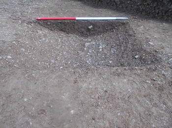
The remains of a post-medieval/modern field boundary ditch was identified in the centre of the site, its position and alignment suggesting that the modern field once comprised two smaller fields. The boundary is not shown on the First Edition 1884 Ordnance Survey map of the area, indicating that the boundary had been removed before this date. The other dated feature was a relatively large pit of a similar date, which may have been dug to extract sand and gravel. Four undated ditches in the western half of the site are probably the remains of an earlier agricultural field system, probably associated with the Late Iron Age/Roman settlement c. 300m to the north-west of the current site.
