
St Michael's Catholic School-Aylesbury Campus, Weedon Road, Aylesbury, Buckinghamshire. Archaeological Evaluation (OASIS ID: cotswold2-317823)
Cotswold Archaeology, 2018. https://doi.org/10.5284/1048343. How to cite using this DOI
Data copyright © Cotswold Archaeology unless otherwise stated
This work is licensed under the ADS Terms of Use and Access.

Primary contact
Cotswold Archaeology
Building 11
Kemble Enterprise Park
Cirencester
GL7 6BQ
UK
Tel: 01285 771022
Fax: 01285 771033
Resource identifiers
- ADS Collection: 3256
- DOI:https://doi.org/10.5284/1048343
- How to cite using this DOI
Introduction
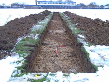
In December 2017, Cotswold Archaeology carried out an archaeological evaluation of land at St Michael’s Catholic School - Aylesbury Campus, Weedon Road, Aylesbury, Buckinghamshire. The evaluation, which was commissioned by BAM Construction, acting on behalf of Buckinghamshire County Council, was carried out to support a planning application. The evaluation comprised the excavation of fourteen 30m long trenches.
A single posthole of possible late prehistoric date was recorded in the south-west of the site. A ditch aligned on a north-east/south-west axis ran across the north of the site, this produced pottery of Roman date. A similarly aligned, undated ditch was revealed in the east of the site and is considered likely to represent broadly contemporary activity and relate to the same field system.
Six trenches excavated along the south-western half of site contained large possible pits, the full extent of which was not visible within the trenches. It is considered likely that these represent the remains of two or three large possible quarry pits, dated to the post-medieval period. These were truncated by two post-medieval parallel ditches running on a north-west/south-east alignment. These ditches appear to correspond with those recorded on the Enclosure Map of 1771, shown as a trackway running between two fields. Another ditch to the east corresponds with a field boundary identified on the First Edition Ordnance Survey Map of 1879.
In the centre of the site five small pits were excavated which contained post-medieval finds, one of which included the articulated remains of the front end of a small cow skeleton.
Overall, the site is generally characterised by agricultural activity of post-medieval date along with evidence for post-medieval quarrying. An isolated posthole of possible late prehistoric date was recorded in the south-west of the site and a ditch of probable Roman date was recorded at the north of the site along with an undated ditch on a similar alignment, considered likely to be broadly contemporary.
