
Island Farm, Ottery St. Mary, Devon. Archaeological evaluation and excavation
Cotswold Archaeology, 2018. https://doi.org/10.5284/1047562. How to cite using this DOI
Data copyright © Cotswold Archaeology unless otherwise stated
This work is licensed under the ADS Terms of Use and Access.

Primary contact
Cotswold Archaeology
Building 11
Kemble Enterprise Park
Cirencester
GL7 6BQ
UK
Tel: 01285 771022
Fax: 01285 771033
Resource identifiers
- ADS Collection: 3151
- DOI:https://doi.org/10.5284/1047562
- How to cite using this DOI
Introduction
A programme of archaeological evaluation and strip, map and sample excavation was undertaken by Cotswold Archaeology between February 2012 and April 2014 at the request of Waddeton Park Ltd at Island Farm, Ottery St Mary, in advance of subsequent housing development by Bovis Homes Ltd.
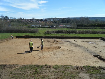
Three trenches were excavated in 2012, a further 22 in 2013. The evaluations identified a number of archaeological features which generally correlated well with the results of a preceding geophysical survey and cartographic evidence. Archaeological features encountered comprised ditches, pits, postholes, spreads of charcoal rich material (producing a residual Bronze Age palstave) and a wall footing broadly dated to the medieval period and buried soil horizons dated to the prehistoric, medieval and post-medieval periods.
The four excavation areas, which had been chosen for their archaeological potential as identified in previous evaluations, all revealed archaeological features. These included pits yielding flints of Mesolithic and early Neolithic date, and most significantly, a medieval building that had apparently suffered fire damage and preserved evidence of its wooden structure and stored crops. There were numerous drainage ditches, some of which may have been prehistoric, but most medieval and later. Some corresponded to 19th-century mapped field boundaries. This document presents a quantification and assessment of the evidence recovered from the excavation. It considers the evidence collectively in its context, and presents proposals to bring the results to appropriate publication.
The excavation was published in: Mudd, A., Cobain, S. and Haines, C. 2018. A Medieval Building and its Contents at Island Farm, Ottery St Mary, East Devon: excavations in 2014, Internet Archaeology 47.
