
Defence of Britain Archive
Council for British Archaeology, 2002. (updated 2006) https://doi.org/10.5284/1000327. How to cite using this DOI
Data copyright © Council for British Archaeology unless otherwise stated
This work is licensed under the ADS Terms of Use and Access.

Primary contact
Council for British Archaeology
92 Micklegate
York
YO1 6JX
England
Tel: +44 (0)1904
Fax: 671417
Resource identifiers
- ADS Collection: 324
- DOI:https://doi.org/10.5284/1000327
- How to cite using this DOI
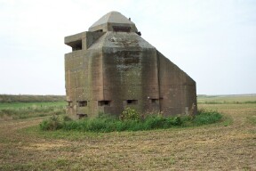
Minefield Control Tower.
Unique, 22ft high x 20ft wide observation post built as a two storey hexagonal tower surmounted by a concrete cupola. Constructed of 2ft thick concrete, the lower level is a pillbox/strong point with a total of seventeen embrasures at two heights giving 360 degree defence. The upper floor is reached by an open hatchway (no ladder). This is a 16ft wide room with a high pyramidal ceiling at the apex of which is the 6ft wide cupola containing a firing embrasure with a steel flap in each of its six sides. The dominant feature of the upper room is a concrete platform above which is a 6ft x 16ft wide look-out slot set in the south wall [this looks very like a field gun emplacement and the cupola embrasures the look-out slots].
From this position one can see above a sea wall (some 50yds) to the front of the tower, and out across the mouth of the River Crouch. The building, striking for its size is listed as OP by reference 1 `Wartime Contraventions 1968'. `Fortifications of East Anglia' (reference 2) shows a sketch and states `The Crouch was defended by a mine field controlled from this tower on the north bank.'
(Source: Field Visit 1193/02)
| Type of site | MINEFIELD CONTROL TOWER |
|---|---|
| Location | SE of Holliwell Farm, Burnham-on-Crouch. |
| Area |
Burnham-on-Crouch, Essex, England |
| Grid reference |
TR 0166 9582
|
| Period | WW2 |
| Condition | Good |
| Materials | Concrete, Steel |
| Recorder | Nash, Fred (Archaeological Advisory Group, Essex County Council Planning) |
| Defence grouping |
Essex coast defences - Coastal crust defences |
| Photographs |
(1) - external view. |
| DOB site reference: | S0000442 |
| Associated Identifier | Essex SMR (ref: 10004) |
| Reference |
1998/06 World War Two Defences in Essex, Interim Report 1968 Burnham-on-Crouch 1988 Fortifications of East Anglia |
| Event |
Construction, In the period 1940 1941 Field Visit, In 1993/02 |
