
Defence of Britain Archive
Council for British Archaeology, 2002. (updated 2006) https://doi.org/10.5284/1000327. How to cite using this DOI
Data copyright © Council for British Archaeology unless otherwise stated
This work is licensed under the ADS Terms of Use and Access.

Primary contact
Council for British Archaeology
92 Micklegate
York
YO1 6JX
England
Tel: +44 (0)1904
Fax: 671417
Resource identifiers
- ADS Collection: 324
- DOI:https://doi.org/10.5284/1000327
- How to cite using this DOI
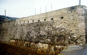
Defensive wall formed by adapting a section of Mevagissey inner harbour wall as a loopholed wall. This wall was made by heightening the harbour wall with concrete and incorporating 9 loopholes, measuring approx. 10ins width x 9ins height. The wall is 57ins thick and has a firestep on the land side. The field of fire from the loopholes covered the harbour entrance and harbour walls. The wall remains in excellent condition - the inner part is in use as a net storage area.
(Source: Field Visit 1999/02/15)
| Type of site | LOOPHOLED WALL |
|---|---|
| Location | Part of Mevagissey inner harbour wall. |
| Area |
St. Ewe, Cornwall, England |
| Grid reference |
SX 0167 4400
(Scale: 1:25000
, 1997)
|
| Period | WW2 |
| Condition | Good |
| Materials | Concrete |
| Recorder | Harvey, Alwyn (Fortress Study Group) |
| Defence grouping |
Cornwall coast defences - Defences of the Cornwall coastal crust. |
| Attached Sheets | (2) - sheets with attached photographs. |
| Photographs |
(4) - site views (1 DIGITISED). |
| DOB site reference: | S0006697 |
| Event |
Construction, In the period 1940 1941 Field Visit, On 1999/02/15 |
