
Defence of Britain Archive
Council for British Archaeology, 2002. (updated 2006) https://doi.org/10.5284/1000327. How to cite using this DOI
Data copyright © Council for British Archaeology unless otherwise stated
This work is licensed under the ADS Terms of Use and Access.

Primary contact
Council for British Archaeology
92 Micklegate
York
YO1 6JX
England
Tel: +44 (0)1904
Fax: 671417
Resource identifiers
- ADS Collection: 324
- DOI:https://doi.org/10.5284/1000327
- How to cite using this DOI
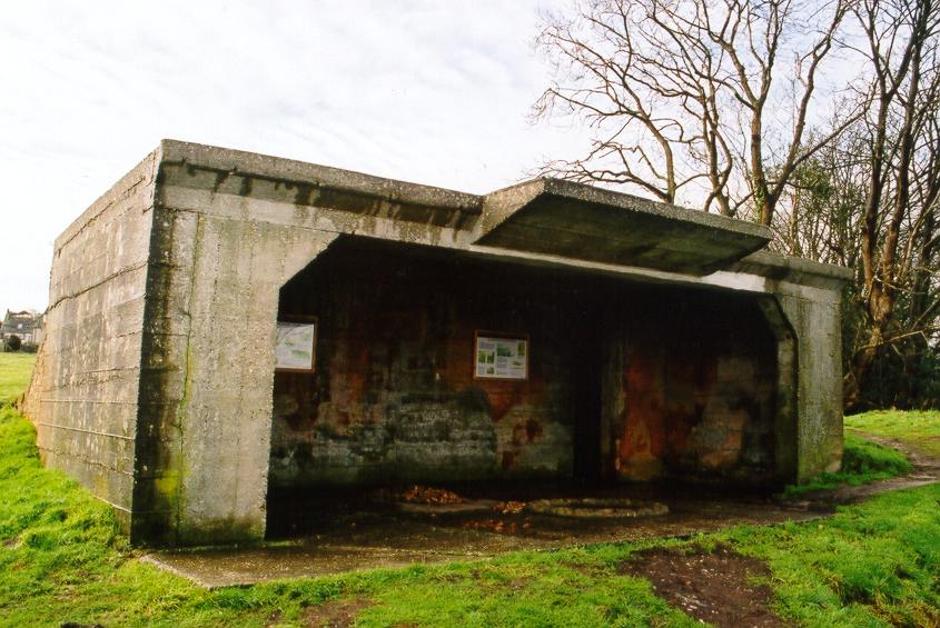
A gun emplacement built to cover the approach to Studland Bay. Its line of fire was partly blocked by the later construction of Fort Henry. It is made of reinforced concrete and measures 7.3m x 3.6m internally. The NE entrance is 6m wide with a 2.7m long concrete canopy built centrally above the entrance and extending 1m from the face of the structure. The gun holdfast circle survives in the centre of the main chamber. The SW wall is still painted with khaki and green camouflage patterns. The walls of the building are 0.3m thick. There are passages leading from the W and S corners. The S passage leads SW and is entered via 7 steps. It is 4m long and 0.6m wide and leads to a room 2.4m x 2.4m with two ventilation shafts. The W passage may also have had steps. It curves from SW to W and leads to a room measuring 3m x 2.4m with 2 ventilation shafts. Both passages are underground and of brick with concrete roofs. They are probably accommodation and ammunition storage areas.
This is a well preserved site used as a stable. The ventilation shafts to the underground chambers have been damaged. The building lies in the corner of a pasture field with scrub woodland beyond fences to the NE and NW.
(Source: Field Visit 1995/10)
Concrete gun emplacement with passages to two underground magazines to the rear. Interior retains original camouflage paint. Graffiti on the roof reads, "R. Daman 1940. AG 229 Batt. 58th Med. Reg."
(Source: Field Visit 1993)
6pdr. gun position. Probably this site. Cassini ref. 469033 [one source gives 470033 and 4in gun in addition to 6pdr.]. Manned by No.2 East Purbeck Coy, 7 Wareham Bn., Home Guard. The task was directed against enemy boats.
(Source: Document 1943)
Gun emplacement looking over Studland Bay. Main emplacement is reinforced concrete with roof and open front. Two underground areas to the rear through side passages down steps were probably living and ammunition areas; these are of brick walls and reinforced concrete roof. The left hand rear area has two ventilation shafts open but destroyed above ground. The gun mounting base was traceable but covered in earth and manure - the area is used as a horse stable.
[with plan drawn on form showing measurements].
(Source: Field Visit 1993/04/06)
Concrete gun emplacement standing just to the W of the later Fort Henry observation bunker which blocked its field of fire. It is used today by the National Trust to display information boards.
(Source: Field Visit 2003/01/19)
4in and 6pdr gun emplacements. 69 Inf. Bde. Cassini ref. 471032. Another source gives, 470033.
(Source: Document 1940/09/15)
One static 4in gun and one static 6pdr. Cassini ref. 471032.
(Source: Document 1941)
| Type of site | GUN EMPLACEMENT |
|---|---|
| Location | Behind Fort Henry, Redend Point, Studland - on the tip of Redend Point. |
| Area |
Studland, Dorset, England |
| Grid reference |
SZ 03769 82852
|
| Period | WW2 |
| Condition | Good |
| Materials | Clay Brick, Concrete, Reinforced Concrete |
| Recorder | Armishaw, A. |
| Defence grouping |
Dorset coast defences - Defences of the Dorset coast line and immediate hinterland. |
| Attached Sheets | (2) - sheets of reproduced photographs. |
| Photographs |
(5) - on two sheets, interior and exterior views. |
| Adjacent sites | Observation bunker directly in front of battery [see NAI 2641]. |
| DOB site reference: | S0007717 |
| Associated Identifier | National Trust SMR (ref: 112573) |
| Reference |
1995 Military Dorset Today 1943 Standing Operation Instruction 1941/04/14 1 Coldstream Guards Defence Scheme 1941/04/04 7 Suffolk Defence Scheme No.1 1940/09/15 50 Division 'G' War Diary 1941 210th Infantry Brigade War Diary |
| Event |
Field Visit, During 1995/10 Construction, In the period 1940 1941 Field Visit, During 1993 Field Visit, On 1993/04/06 Field Visit, On 2003/01/19 |
