
Unlocking historic landscapes in the eastern Mediterranean
Jim Crow, Sam Turner, 2010. https://doi.org/10.5284/1000119. How to cite using this DOI
Data copyright © Prof Jim Crow, Sam Turner unless otherwise stated
This work is licensed under the ADS Terms of Use and Access.

Primary contact
Sam
Turner
Newcastle University
School of History, Classics and Archaeology
Newcastle upon Tyne
NE1 7RU
UK
Resource identifiers
- ADS Collection: 917
- DOI:https://doi.org/10.5284/1000119
- How to cite using this DOI

Introduction
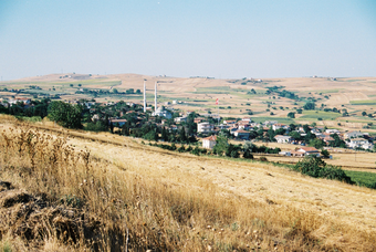
The open landscape around the village of Fener, Thrace. July 2007. Photo: Sam Turner.
In many areas of the Eastern Mediterranean there are landscapes exhibiting exceptional time-depth, where the historic landscape is made up of visible features from many different periods. Our research adapted and used a new technique developed in Britain (Historic Landscape Characterisation - HLC) for the first time in the eastern Mediterranean to study these landscapes. HLC is a method for mapping the landscape that can be used to interpret how and when different elements were created. Using Geographical Information Systems (GIS) we integrated data from historical, archaeological and other sources to create detailed, long-term landscape histories of two case-studies areas.
This project investigated:
- How we can use cost-effective new methods to understand Mediterranean landscapes on a large scale
- How the rural landscapes of the Aegean have been shaped by social and economic life over the last 1500 years
- Whether the pace of change been comparable in two study aeas, or whether there have there been periods when people have changed some rural landscapes much faster than others
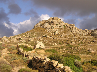
Apano Kastro, Naxos. October 2006. Photo: Jim Crow
Our project studied the historic landscape of the Aegean through the analysis of two rural landscapes in Naxos (Greece) and Thrace (Turkey). It has only recently become possible to undertake such in-depth study of widely separated landscapes. Geographical Information Systems (GIS) now provide a tool for combining and comparing diverse datasets such as orthorectified aerial photographs, satellite data, digital mapping, and data on settlement patterns. In particular, Historic Landscape Characterisation provides a framework for integrated diachronic landscape histories that incorporate data from relevant historical and archaeological sources at a range of scales.
Understanding the development of the cultural landscape is certainly a crucial issue for historians, but its importance goes much further. Cultural landscapes form the backdrop to our lives and provide a key element in our sense of place and identity. It is essential that we understand them so that we can manage them effectively and develop them sustainably. By revealing the value in regional landscapes and the real nature of the similarities and differences between regions, this research could have implications for ordinary people, planners and policy-makers from the local to the international level.
Aims:
- to understand the changing historic landscape in two Aegean case-studies
- to demonstrate the applicability of Historic Landscape Characterisation (HLC) for Mediterranean landscapes
Objectives:
- to adapt and use the HLC method in the eastern Mediterranean
- to map historic landscape character in two case-study areas
- to identify the principal periods of landscape change in each area since the late Roman period
- to produce print and online publications to disseminate the results of the research
Method:
- to undertake GIS-based HLCs of 2 study areas each of 200 km2 (study areas: Naxos, Greece and Silivri, Thrace, Turkey)
- To make comparisons of the long-term social and economic histories of the landscapes of the study areas and to analyse similarities and differences in their trajectories towards today's historic landscapes
Our publications relating to the project include:
Turner, S. and J. Crow, 2010. 'Unlocking historic landscapes in the eastern Mediterranean: two pilot studies using historic landscape characterisation', Antiquity 84 (323), 216-229.
Crow, J. and S. Turner, 2009. 'Silivri and the Thracian hinterland of Istanbul: an historic landscape', Anatolian Studies 59, 167-181.
and the project's own website
