
England's Historic Seascapes: Southwold to Clacton
Oxford Archaeology (South), 2007. https://doi.org/10.5284/1000277. How to cite using this DOI
Data copyright © Historic England unless otherwise stated
This work is licensed under the ADS Terms of Use and Access.


Primary contact
Oxford Archaeology (South)
Janus House
Osney Mead
Oxford
OX2 0ES
UK
Tel: 01865 263800
Fax: 01865 793496
Resource identifiers
- ADS Collection: 746
- ALSF Project Number: 4729
- DOI:https://doi.org/10.5284/1000277
- How to cite using this DOI
England's Historic Seascapes:
Southwold to Clacton
ALSF Project Number 4729
Oxford Archaeology, 2007
Clacton Area Coastal Waters
Primary Subcharacter Type:
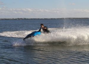
Watersports area
Main Character / current form and use
The character area runs roughly parallel to the Clacton Area encompassing the coastal waters off the seaside resort towns of Essex's 'Sunshine Coast' (Clacton, Frinton, Walton). Its predominant characteristic is its role as an offshore extension of these resorts, incorporating popular bathing waters, primary leisure sailing routes and designated watersports zones. Recreational fishing is known to take place in the offshore areas off Jaywick Clacton and Walton (http://www.leader-lines.com/) and the area is a potential recreational dive site. The character area also contains a significant number of pipelines associated with the resorts. The seaward portion of the area includes part of the Gunfleet military area (see Gunfleet Sands and Wallet).
Geologically, the character area mainly comprises gravelly, muddy sand or muddy gravel overlying the erosion resistant bedrock elements of the basal part of the London Clay formation. The area lies on a shallow shelf with depth ranging from 2 m to 10 m. The tidal range in the character area is within the range of 4-5 m at Mean Spring Tide (DTI 2004). Named areas within the seabed include Priory Spit, Collier, Tripod, Naze Ledge and Copperas Ground. Many of these are known navigational hazards. Naze Ledge is the product of cemented volcanic ash contained within the London Clay and can be a navigational hazard. Priory Spit, Collier and Tripod are small sandbanks. The UK Hydrographics Office has recorded a total of 13 obstructions within this area.
The Clacton Coastal area is subject to a number of restrictions and cautions related to traffic associated with the ports of Harwich and London and is consequently covered by vessel traffic services.
Historic Character and archaeological potential
The presence of a region named 'Copperas Ground' indicates that this area was probably once an extraction site for copperas (see link). The character area contains 11 wrecks, four of which are considered dangerous. The archaeological potential of these wrecks is unknown.
The proximity of the character area to the prehistoric 'Lyonesse surface' (Link) and the important Palaeolithic site at Clacton indicate that it may have high potential for submerged landscapes or prehistoric remains. The Clacton Coastal area is also within the region of relatively recent coastal erosion and has been closely related to the coastline for thousands of years indicating its potential for archaeological features from the Palaeolithic through to the modern period. Much of the historic town of Walton has been lost to the sea through sea level rise and coastal erosion, including two Roman shore forts and this area may contain elements or artefacts resulting from this process.
Character perceptions
The character area is popular with tourists and leisure sailors and may be viewed as an integral part of the tourist industry in this region. It can be perceived as a seamless extension of the 'Sunshine Coast' resorts.
Bibiliography
DTI, 2004, Mean Spring Tidal Range: Atlas of UK Marine Renewable Energy Resources. Department of Trade and Industry, 2004
Allen, T. & Pike, G., 2007, The Tankerton cooperas works and the copperas industry in the south of England. Canterbury Archaeology Trust. Available at: http://www.eng-h.gov.uk/archcom/projects/summarys/html97_8/2059.htm (15/03/2007)
Wilkinson, T.J. & Murphy, P.L. 1995. The archaeology of the Essex coast, Volume 1: The Hulllbridge Survey, East Anglian Archaeology 71, 238 Archaeology Section, Essex County Council, Chelmsford
Williams, J. & Brown, N., 1999, An Archaeological Research Framework for the Greater Thames Estuary. Essex County Council
English Heritage. Available at http://www.english-heritage.org/ (07/03/2007)
Leader Lines. Available at: http://www.leader-lines.com/ (07/03/2007)
Wikipedia. Available at: http://en.wikipedia.org (15/03/2007)
