
England's Historic Seascapes: Southwold to Clacton
Oxford Archaeology (South), 2007. https://doi.org/10.5284/1000277. How to cite using this DOI
Data copyright © Historic England unless otherwise stated
This work is licensed under the ADS Terms of Use and Access.


Primary contact
Oxford Archaeology (South)
Janus House
Osney Mead
Oxford
OX2 0ES
UK
Tel: 01865 263800
Fax: 01865 793496
Resource identifiers
- ADS Collection: 746
- ALSF Project Number: 4729
- DOI:https://doi.org/10.5284/1000277
- How to cite using this DOI
England's Historic Seascapes:
Southwold to Clacton
ALSF Project Number 4729
Oxford Archaeology, 2007
East Swin and Sunk Sand
Sunk Head Sea Fort
The tower is one of four similar structures designed by G A Maunsell and placed in the North Sea to protect London and the coastal areas from enemy aircraft and shipping attacks. The forts were intended to act as an early warning system, break up aircraft formations and prevent minelaying. This was particularly crucial as the Luftwaffe were dropping a new German Magnetic Influence Mine by parachute from seaplanes resulting in heavy shipping losses (http://www.bobleroi.co.uk). Each fort had a steel gun platform with two anti-aircraft guns, a control tower and radar equipment (http://www.offshoreechos.com/). The platform of the forts were supported by two 8m diameter concrete legs on a pontoon base. The forts adopted the MOD code Uncle with each given the abbreviation U. The Sunk Head fort was known as U2 and for unknown reasons was often called Churchill One. The forts were abandoned in 1956 and many were utilised by pirate radio stations in the 1960s. Sunk Head fort was blown up by the military in 1967 to avoid further use.
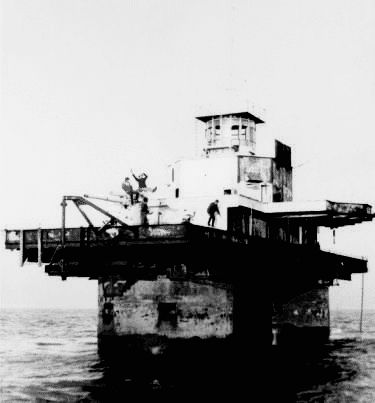
Caption: Sunk Head Fort in 1966 in use as Tower Radio
Courtesy: Offshore Echoes
