
Excavations at Friernhay Street, Exeter 1981 (Exeter archive site 75)
Exeter City Council, Cotswold Archaeology, 2015. https://doi.org/10.5284/1035212. How to cite using this DOI
Data copyright © Exeter City Council unless otherwise stated
This work is licensed under the ADS Terms of Use and Access.

Primary contact
Andrew
Pye
Principal Project Manager (Heritage)
Exeter City Council
Civic Centre
Paris Street
Exeter
EX1 1NN
England
Tel: 01392 265 224
Resource identifiers
- ADS Collection: 2041
- DOI:https://doi.org/10.5284/1035212
- How to cite using this DOI


Introduction
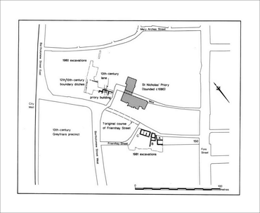
From January to June 1981, the Exeter Museums Archaeological Field Unit undertook an excavation on a plot of land adjacent to an angle in Friernhay Street on its south-western side. The site was formerly occupied by Wheatons' printing works and was later acquired for housing.
The site was situated off Friernhay Street at SX 9172 9244 and straddled an area of the defences of the former Roman legionary fortress at Exeter.
Excavation was by the open-area method with accompanying sections to recover details of the stratigraphy. The main area of the site was approximately 35 metres north-west/south-east by 22 metres north-east/south-west. The site was crossed by many modern service trenches, particularly in the south-eastern part of the site.
Remains of the post-medieval, medieval and Roman civil periods were recorded overlying the deposits of the Roman military period which, at Exeter, is dated from c AD 55/60 to c AD 75/80.
A long stretch, some 55 metres, of the south-western defences of the legionary fortress was investigated including a 35-metre stretch of the rampart. The two successive defensive ditches of the fortress were also observed at various points forward of the rampart along a length of 48 metres.
