
The Archaeological Landscape of Frampton on Severn, Gloucestershire
Gloucestershire County Council, 2014. https://doi.org/10.5284/1025046. How to cite using this DOI
Data copyright © Gloucestershire County Council unless otherwise stated
This work is licensed under the ADS Terms of Use and Access.


Primary contact
Toby
Catchpole
Archaeology Service
Gloucestershire County Council
Shire Hall
Westgate Street
Gloucester
GL1 2TH
England
Tel: 01452 425681
Fax: 01452 425356
Resource identifiers
- ADS Collection: 1619
- ALSF Project Number: 4625
- ALSF Project Number: 5171
- DOI:https://doi.org/10.5284/1025046
- How to cite using this DOI

Downloads
Reports
- ALSF 4625 and 5171 Final report, Mullin 2011
- ALSF 5171 Post-excavation assessment and updated project design, Mullin 2007
- ALSF 5171 Project design for post-excavation assessment, Mullin 2007
- ALSF 5171 Evaluation report and updated project design, Catchpole 2006
- ALSF 4625 Updated project design, Mullin 2006
- ALSF 4625 NMP report, Dickson 2007
ALSF 4625 and 5171 Final report
Mullin, D. 2011, A Round Barrow Cemetery in the Severn Vale: Richard Atkinson's Excavations of Five Ring Ditches at Netherhills, Frampton on Severn, 1948 and their Archaeological Context.
|
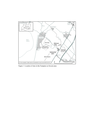
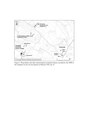
Figure 1: Location of sites in the Frampton on Severn area | 988 Kb | |
|
Final report text for projects 4625 and 5171. The report includes specialist reports and 15 tables | 1 Mb | |
|
Figure 10: Sections from Netherhills Sites 2 and 3, redrawn from the Atkinson archive | 899 Kb | |
|
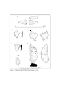
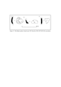
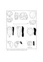
Figure 20: Lithics from the 2007 GCCAS excavations, pit 1001 | 1 Mb | |
|
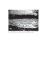
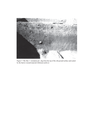
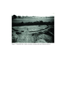
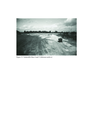
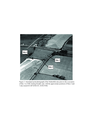
Figure 4: Netherhills Sites 1 and 3 during excavation | 3 Mb | |
|
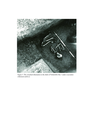
Figure 5: Crouched inhumation Netherhills Site 1 under excavation | 9 Mb | |
|
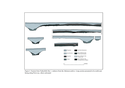
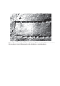
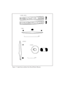
Figure 6: Section from Netherhills Site 1, redrawn from the Atkinson archive | 949 Kb | |
|
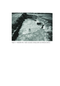
Figure 7: The Site 1 'cremation pit' | 2 Mb | |
|
Figure 8: Close-up photographic detail of a comb-impressed Beaker sherd from Atkinson's excavations | 3 Mb | |
|
Figure 9: Netherhills Site 2 under excavation | 11 Mb | |
|
Front cover of report | 785 Kb | |
|
Figure 11: Netherhills Site 3 under excavation | 13 Mb | |
|
Figure 12: Sections from Netherhills Sites 4 and 5, redrawn from the Atkinson archive | 872 Kb | |
|
Figure 13: Netherhills Sites 4 and 5 (Atkinson archive) | 10 Mb | |
|
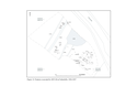
Figure 14: Features excavated by GCCAS at Netherhills, 2006-2007 | 938 Kb | |
|
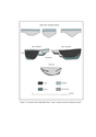
Figure 15: The Beaker pottery found in pit 1003 from the 2006-2007 | 1 Mb | |
|
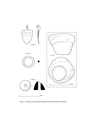
Figure 16: Roman artefacts from Stroud District Museum. Figure 16 for above report | 956 Kb | |
|
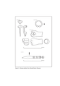
Figure 17: Anglo-Saxon artefacts from Stroud District Museum | 466 Kb | |
|
Figure 18: Medieval and undated artefacts from Stroud District Museum | 932 Kb | |
|
Figure 19: Lithics from the 2007 GCCAS excavations, pit 1001 | 1 Mb | |
|
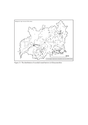
Figure 2: Crop marks recorded by the NMP in the Frampton on Severn area | 3 Mb | |
|
Figure 21: The distribution of recorded round barrows in Gloucestershire | 1 Mb | |
|
Figure 3: Annotated aerial photograph of the Netherhills sites | 2 Mb |
