
Landscape Archaeology and Community in Devon: An Oral History Approach
David Harvey, 2005. https://doi.org/10.5284/1000091. How to cite using this DOI
Data copyright © Dr David Harvey unless otherwise stated
This work is licensed under the ADS Terms of Use and Access.

Primary contact
Dr
David
Harvey
Department of Geography
University of Exeter
Laver Building
North Park Road
Exeter
EX4 4QE
UK
Tel: 01392 263330
Resource identifiers
- ADS Collection: 406
- DOI:https://doi.org/10.5284/1000091
- How to cite using this DOI

Introduction
Rationale of the Project
The project uses oral history in order to advance and enhance existing knowledge of landscape change, to test and challenge the formation of this knowledge and thereby bring greater understanding to our study of the meaning of landscape. Due to the dramatic changes taking place in the countryside at present, it is important to analyse the way in which communities adapted to, and gave meaning to previous radical changes in land use.
The project has three specific research questions:
- To document the nature of farming history within the areas of Devon that are currently under investigation in the landscape archaeology projects.
- To relate landscape changes produced by the WW2 plough up campaign on both previous and subsequent landscape histories.
- To evaluate socio-cultural meanings of such landscape changes in rural communities.
Oral history is being used in this project not just as an academic method to be used alongside a suite of other methods, but also as a subject in its own right. In this sense, further research questions which have evolved in the project include:
- To what extent do 'eye-witness' testimonies augment, agree with, or contest other lines of enquiry?
- To what extent can oral histories provide an analogue map for previous landscape changes that have been identified through archaeological, historical and palaeo-environmental techniques?
The Study Areas
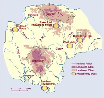
The project broadly focuses on four study areas that are already the subject of detailed work in the School of Geography, Archaeology and Earth Resources at the University of Exeter:
- Hartland Peninsular
- Knowstone/Rackenford area
- Blackdown Hills
- Broadclyst area
Reconsidering the Second World War
The project focuses primarily on the World War 2 (WW2)
Documentary sources and anecdotal evidence has suggested that arable cultivation was widespread as part of the WW2 'plough up' campaign. While arable farming at over 250m above sea level is now rare in Devon, resulting in the general view of these areas as unchanging, socially backward and bound up with a particular 'traditional way of life', these views are clearly misguided and the project aims to document the wartime experiences and practices of these areas before such first hand knowledge is lost. WW2 is used in the belief that periods of landscape stress (such as the Napoleonic campaign or later medieval period) had a profound effect on both the landscape and its population, and we use WW2 as an analogous case to consider the nature of these changes in relation to social and cultural, as well as environmental factors.
