
Latton Lands Gravel Pit, North Wiltshire
Oxford Archaeology (South), 2008. https://doi.org/10.5284/1000360. How to cite using this DOI
Data copyright © Oxford Archaeology (South) unless otherwise stated
This work is licensed under the ADS Terms of Use and Access.


Primary contact
Lisa
Brown
Senior Project Manager
Oxford Archaeology (South)
Janus House
Osney Mead
Oxford
OX2 0ES
UK
Tel: 01865 263800
Fax: 01865 793 496
Resource identifiers
- ADS Collection: 876
- ALSF Project Number: 3694
- DOI:https://doi.org/10.5284/1000360
- How to cite using this DOI

Overview
The site is situated in north Wiltshire, to the east of the River Churn, north-west of Cricklade and approximately 8 km to the south-east of Cirencester. The development site, a quarry owned by Cotswold Aggregates, covered an area of 14 ha close to Cerney Wick, north-west of the village of Latton, centred upon NGR SU 085 961. The site represents a significant element of a wider archaeological landscape lying between the old A419 road (Ermin Street Roman road) to the north-east, a scheduled Romano-British settlement (SAM 899) to the south and a Bronze Age settlement to the west. It is within the landscape study area investigated as a series of projects now forming the Cotswold Water Park Project.
Prehistoric and Roman remains were exposed during fieldwork undertaken by Oxford Archaeology in advance of gravel extraction. An isolated oval enclosure (PRN 621) dating to the late Neolithic/early Bronze Age may have had a ritual function. An extensive early Iron Age settlement complex included a number of roundhouses associated with pits, waterholes, four-post structures and animal burials. Middle Iron Age activity included a series of penannular gullies superseded by a major boundary ditch, field system and enclosures. During the late Iron Age or early Roman period the boundary was modified and a group of enclosures constructed. Later in this period, inhumation and cremation burials, including an unusual partially burnt burial, were interred in the fill of the major late Iron Age enclosure. The excavation also exposed the northern part of a scheduled Romano-British settlement site (SAM 899), which lay to the south of Ermin Street. Roman trackways, quarries, enclosures, pits and inhumation and cremation burials were recorded. Medieval ridge and furrow and post-medieval ditches transected the prehistoric and Roman sites.
The digital archive
The project archive currently comprises the following components:
Project Reports
The final report, complete with figures and appendices can be accessed from the downloads page. When quoting this work please use the following reference:
- Powell,K., Laws,G. and Brown,L. 2008: A Late Neolithic / Early Bronze Age enclosure and Iron Age and Romano-British settlement at Latton Lands, Wiltshire.
In addition the archive also includes the full array of post-excavation specialist reports comprising:
- Animal Remains - by Kristopher Poole
- Radiocarbon Dating - S Griffiths, P Marshall, A Bayliss, J van der Plicht, and G Cook
- Ceramic Building Material - Martin Greaney
- Charcoal - Dana Challinor
- Coins - anon
- Copper Alloy debris - anon
- Fired Clay - Emily Edwards
- The flint - Kate Cramp
- Human Bone - Jonny Geber
- Insect and Mollusc remains - Mark Robinson
- The Late Iron Age and Roman Pottery - Dan Stansbie
- Metalwork - Kelly Powell
- Prehistoric Pottery - anon
- Samian Stamps - anaon
- Slag - G. C. Morgan
- Waterlogged Wood - Maisie Taylor
- Charred and Waterlogged Plant Remains - Seren Griffiths
Project GIS
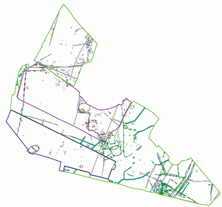
The project GIS archive comprises 30 Esri shapefiles digitised from hand drawn site plans of excavation at 1:20 or 1:50 and location surveyed on site using a combination of GPS and Total Station. Tied into OS data at a scale of 1:2500.
Earlier work was conducted purely using hand drawn plans, migrating to digital capture augmented with hand drawn detail by the end of the work programme. No attempt has been made to match up features between different phases of work. Features within each GIS layer have been tagged with an identifier when relevant to post excavation work.
The shapefiles are accompanied by documentation detailing the contents of each file (description, projection, attribute codes)
Context and Pottery databases
The archive includes the Context and Pottery databases, available to download as comma delimited text files (.csv).
Non-digital Archive and Publications
In addition to the reports contained within the digital archive the project also produced the following outputs:
| Journal Articles |
|---|
| Stansbee,D. and Laws,G. 2004: Prehistoric settlement and medieval to post-medieval field systems at Latton Lands, Wiltshire, Wiltshire Studies: the Wiltshire Archaeological and Natural History Magazine, 97 2004, pp106-143. |
The physical archive currently resides with Oxford Archaeology and is to be deposited with Gloucester Museum.
The Archaeology Data Service (ADS) do not hold any further information regarding these non-digital outputs, any queries should be directed to the depositor.
