
Identifying coastal archaeology using multi-spectral satellite imagery of the intertidal zone
Helene Burningham, Julie Satchell, Ole Grøn, Tomas Hunniche, 2011. https://doi.org/10.5284/1000420. How to cite using this DOI
Data copyright © Dr Helene Burningham, Julie Satchell, Prof Ole Grøn, Tomas Hunniche unless otherwise stated
This work is licensed under the ADS Terms of Use and Access.

Primary contact
Dr
Helene
Burningham
Department of Geography
University College London
Coastal & Estuarine Research Unit
Department of Geography
Pearson Building
Gower Street, London
WC1E 6BT
England
Resource identifiers
- ADS Collection: 1047
- DOI:https://doi.org/10.5284/1000420
- How to cite using this DOI


Introduction
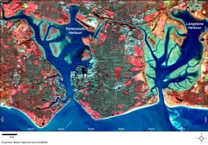
This English Heritage funded project explored the use of multispectral satellite imagery for archaeological investigations in the intertidal zone. As a pilot project, the study focused on the well documented Portsmouth and Langstone Harbours. The aim of the study was to examine the potential of multispectral surveying techniques in the monitoring and management of intertidal cultural heritage. The rationale for the successful use of multispectral imagery in the identification of sub-surface archaeology is based on previous studies of terrestrial archaeology in Scandinavia (e.g. Grøn et al., 2011), where expert interpretation of QuickBird and Ikonos imagery was capable of identifying features as small as cooking pits and post holes within agricultural landscapes. To date, there has been limited investigation of intertidal archaeology using satellite imagery, and hence this study provides a first look - pilot study - evaluation of the potential of this new approach.
References
Grøn, O., Palmer, S., Stylegar, F.-A., Esbensen, K., Kucheryavski, S., & Aase, S. 2011 Interpretation of archaeological small-scale features in spectral images. Journal of Archaeological Science, doi:10.1016/j.jas.2009.11.023.
