
Drigg Burnt Mound, West Cumbria
Oxford Archaeology North, 2013. https://doi.org/10.5284/1022582. How to cite using this DOI
Data copyright © Oxford Archaeology North unless otherwise stated
This work is licensed under the ADS Terms of Use and Access.

Primary contact
Fraser
Brown
Senior Project Manager
Oxford Archaeology North
Mill 3
Moor Lane Mills
Moor Lane
Lancaster
LA1 1QD
UK
Resource identifiers
- ADS Collection: 1338
- DOI:https://doi.org/10.5284/1022582
- How to cite using this DOI

Introduction
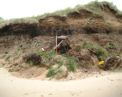
This archive presents the results of archaeological evaluation at the site of a putative Bronze Age hearth or burnt mound at Drigg, West Cumbria (SD 0450 9860), undertaken in October 2000 by Oxford Archaeology North (OA North). The work was commissioned by English Heritage following concerns raised by the Cumbria County Archaeologist and members of the Cumberland and Westmorland Antiquarian and Archaeological Society (hereafter CWAAS), regarding accelerated erosion of the site.
The site lies within a designated Site of Special Scientific Interest, approximately 400m to the north of a minor road between the coast and Holmrook railway station, and is exposed in the west-facing sea cliff. Significant peat deposits, preserved beneath dune sands, are visible in the c4m high cliff section, which presents a simple stratigraphic succession of boulder clay overlain by peat and other organic material, including well-preserved wood, and dune sands of varying depth.
Project Summary
In July 1999 and June 2000, the site was visited by OA North at the invitation of the Cumbria County Archaeologist, at which times the various elements of the site were still visible in section, although continued collapse at the base of the sea cliff demonstrated significant ongoing erosion. As a result, an evaluation sponsored by English Heritage was undertaken in early October 2000, when it was discovered that most of the exposed timbers visible in June 2000 had been destroyed by a rapid acceleration of coastal erosion, although the burnt layer still appeared significant.
Two large fallen blocks from the cliff face were excavated and fully recorded. A stretch of cliff face, including the hearth and a putative palaeochannel noted to the north, was cleaned and recorded by total station survey, supplemented by semi-rectified photography. The surrounding topography was surveyed using GPS and a further putative hearth was discovered exposed in the cliff face some 65m to the north of the evaluation site, although no excavation was undertaken on this feature.
Two trenches were also excavated to establish the surviving extent of the archaeological deposits, Trench A examining the deposit of burnt stone visible in the section, and Trench B one of the extant timbers. All archaeologically significant deposits were sampled extensively for bulk plant macrofossil assessment, and arthropod and palynological assessment, and monolith samples were taken for radiocarbon dating. A large timber encountered during excavation was left in situ, having been protected by geotextile and re-buried.
