
Predictive Modelling of Multi-Period Geoarchaeological Resources at a River Confluence
Tony Brown, Keith Challis, Andy J. Howard, 2008. (updated 2011) https://doi.org/10.5284/1000174. How to cite using this DOI
Data copyright © Prof Tony Brown, Keith Challis, Andy J. Howard unless otherwise stated
This work is licensed under the ADS Terms of Use and Access.


Primary contact
Prof
Tony
Brown
School of Geography
University of Southampton
Shackleton Building
Highfield
Southampton
SO17 1BJ
UK
Tel: 023 8059 5493
Resource identifiers
- ADS Collection: 829
- ALSF Project Number: 3357
- DOI:https://doi.org/10.5284/1000174
- How to cite using this DOI


Overview
Background to the Project
Through the Aggregates Levy Sustainability Fund (ALSF), English Heritage have funded a two year research project into the predictive modelling of the geoarchaeological resources at the confluence of the rivers Trent and Soar. The project is led by principal investigators Professor Tony Brown of the School of Geography, Archaeology and Earth Resources at the University of Exeter, and Dr Andy J Howard and Mr Keith Challis based at the HP VISTA Centre, University of Birmingham. Other project staff include Dr Chris Carey, Dr Emma Tetlow, Lynden Cooper and Mark Kincey.
The aims of the research are:
- To establish a rigorous research model for the future development of pre-determination designs for site evaluation.
- To assess the effectiveness of various airborne and ground based remote sensing methods for archaeological prospection in alluvial environments.
- To derive relationships between pre-extraction site survey data and likely chronostratigraphic and environmental data as part of archaeological assessments.
Recent archaeological work on British river floodplains has suggested that river confluences have been the foci of settlement and human activity since the earliest post-glacial periods. The distribution and nature of the archaeological resource in these regions is directly linked to the geomorphology of the floodplain, both in terms of the original locations of sites as well as their level of preservation or destruction as a result of post-depositional taphonomic processes. A detailed investigation of the geomorphology of a river confluence therefore provides a predictive capability for determining the distribution and survival of archaeological remains.
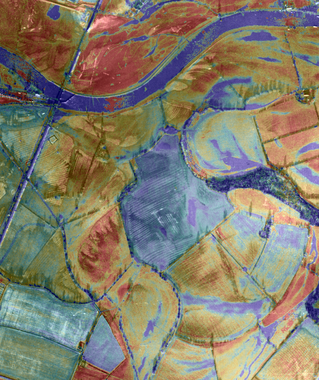
The project incorporated a range of airborne remote sensing techniques including airborne lidar, IFSAR and aerial photography. These airborne data sources were combined with ground-based geophysical surveys, geomorphological mapping and sediment coring to provide a detailed understanding of the surface and sub-surface geomorphology of the study area. The application of radiocarbon and Optically Stimulated Luminescence (OSL) dating techniques to sediment samples allowed the calibration of this relative model to actual chronological frameworks. The methodological approach to assessing the geoarchaeological potential of river confluence environments, as refined through this project, forms a set of guidelines which are equally applicable to other alluvial areas facing future aggregate extraction. The project will therefore be of benefit to both curatorial and contract archaeologists, as well as to the aggregates community themselves, by setting a benchmark for how to assess and characterise both the archaeological and geomorphological resource.
The Digital Archive
The digital archive is an integral part of the reporting process and comprises all files generated in electronic format generated during the course of the project, and for which permissions have been granted for deposit.
The second phase of the project was completed in March 2008. The project comprised a number of elements, each of which has resulted in a report.
The archive contains the following:
- Brown, A.G., Carey, C. J., Howard, A. H., Challis, K. C. and Cooper, L. 2005. Predictive modelling of multiperiod geoarchaeological resources at a river confluence phase I. Unpublished report for English Heritage, funded through the ALSF scheme. PNUM 3357.
- Brown, A. G., Carey, C. J., Howard, A. H., Challis, K. C., Kincey, M. K., Tetlow, E. and Cooper, L. 2007. Predictive modelling of multiperiod geoarchaeological resources at a river confluence phase II. Unpublished report for English Heritage, funded through the ALSF scheme. PNUM 3357.
In February 2011 the archive was updated to include the data produced through the GIS analysis and associated fieldwork. The archive was used to inform the results of the Guides to Good Practice, edited by the Archaeology Data Service.
Non-digital Archive and Publications
The project contributes towards Trent Valley GeoArchaeology, a group of organisations and individuals with interests and involvement in the archaeology and palaeoenvironments of the Trent Valley, the River Trent and its tributaries.
| Journal Articles |
|---|
| A.J. Howard, A.G. Brown, C.J. Carey, K. Challis, L.P. Cooper, M. Kincey and P. Toms 2008: Archaeological resource modelling in temperate river valleys: a case study from the Trent Valley, UK. Antiquity Volume 82 Number 318, pp1040-1054. Abstract can be viewd on the Antiquity Website |
| Carey, C.J., Brown, A.G., Challis, K.C., Howard, A. and Cooper, L. 2006: Predictive modelling of multi-period Geoarchaeological Resources at a River Confluence. Archaeological Prospection 13, 241-250. View Abstract |
| The geology of a floodplain confluence Central England UK using LiDAR, geophysics (GPR & ER) and multi-period dating. Brown, A.G., Carey, C.J., Howard, A., Toms, P. and Challis, K. Geology - in preparation |
| Website |
| A website outlining the project and with an interactive GIS can be found at http://www.tvg.bham.ac.uk/ |
| Meetings / Technical Forums |
| European Association of Archaeologists (EAA) Sept 2005 meeting at Cork. Session "Remote Sensing and Environmental modelling in Alluvial Landscapes" |
| Presentation to Halcrow Ltd, at University of Exeter, October 2005 |
| Paper to Trent Valley Geoarchaeology Conference, December 2006 BGS Keyworth. "ground based geophysical prospection at Lockington (Trent / Soar confluence)". K.Challis, A.Howard, A.G.Brown, C.Carey,M.Kincey and E.Tetlow. |
The Archaeological Data Service (ADS) do not hold any further information regarding these non-digital outputs, any queries should be directed to the depositor.
