
Catchment Tributaries of the River Trent
Keith Challis, Andy J. Howard, 2008. https://doi.org/10.5284/1000053. How to cite using this DOI
Data copyright © Keith Challis, Andy J. Howard unless otherwise stated
This work is licensed under the ADS Terms of Use and Access.


Primary contact
Keith
Challis
Birmingham Archaeology
Birmingham Archaeology
University of Birmingham
Edgbaston
Birmingham
B15 2TT
UK
Tel: 0121 414 5513
Resource identifiers
- ADS Collection: 835
- ALSF Project Number: 3850
- DOI:https://doi.org/10.5284/1000053
- How to cite using this DOI

Overview
Background to the Project
Trent Valley GeoArchaeology 2002 (ALSF 3307) established a comprehensive benchmark in the understanding of the geomorphological character, landscape development and human settlement of the Trent Valley along its entire length. Tributary valleys have received less attention.
However, a number of studies of confluence zones along the river (the Tame-Trent, Where Rivers Meet by Birmingham Archaeology; the Derwent-Trent; the Soar-Trent) indicate that they contain landform assemblages and sediments which provide important archives for understanding changing patterns of river type, sediment supply and hydrological conditions on the main valley floor during the Holocene.
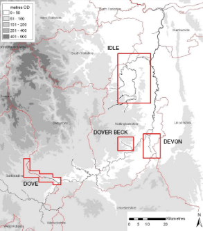
This project therefore involves geoarchaeological assessments of two of the principal tributary valleys of the Trent (the Rivers Dove and Idle) undertaken to assess the impact of their evolution on the main valley floor. Study of the Idle and Dove was complimented, to a limited extent, by consideration of two lesser valleys, (the Devon and the Dover Beck) with the overall aim of identifying landscapes and resources in these tributaries that might elucidate key issues in the study of the main Trent Valley. Study of these tributary valleys is considered important both because of the direct impact of past, present and future aggregate extraction on their cultural heritage and landscape and because research in other major river systems suggests that cultural and climatic signals are less blurred in tributary systems and their study can therefore provide a detailed understanding of processes occurring upon the main valley floor.
The project compliments the on-going research by Birmingham Archaeology and the University of Exeter in the Trent - Tame and Trent - Soar confluences.
The Digital Archive
The digital archive is an integral part of the reporting process and comprises all files generated in electronic format generated during the course of the project, and for which permissions have been granted for deposit.
The archive contains the following reports:
- Challis, K., AJ Howard,, D Moscrop, and Tetlow,E. 2007. Assessing the Geoarchaeological Development of Catchment Tributaries and their Impact on the Holocene Evolution of the River Trent. Draft Assessment Report
The report reports on the collation and analysis of a variety of historic environment record (HER) and remotely sensed data in the project GIS and on a programme of fieldwork aimed at assessing the geoarchaeological character of the studied river valleys and recovering sample for palaeoenvironmental assessment. As far as is possible, given the novel nature of the work, the report is delivered in the guise of a MAP2 Assessment Report.
Section one of the report comprises a brief introduction describing the study areas and the aims and objectives of the work. Section two comprises an assessment of the geoarchaeological record compiled from HER data, remote sensing and field investigation. Section three comprises an assessment of the subsurface geology and geometry of the drift deposits in the studied valleys compiled form analysis of borehole records and through fieldwork. Section four comprises an environmental assessment of the studied valleys based on field investigation and analysis of the past work of others. Section five presents a summary and some conclusions and section six comprises a full bibliography.
