
Wrecks on the Seabed R2: Assessing Evaluating and Recording (Unknown)
Wessex Archaeology, 2012. https://doi.org/10.5284/1017439. How to cite using this DOI
Data copyright © Wessex Archaeology unless otherwise stated
This work is licensed under the ADS Terms of Use and Access.

Primary contact
Wessex Archaeology
Portway House
Old Sarum Park
Salisbury
SP4 6EB
UK
Tel: 01722 326867
Fax: 01722 337562
Resource identifiers
- ADS Collection: 1155
- ALSF Project Number: 3877
- DOI:https://doi.org/10.5284/1017439
- How to cite using this DOI


Introduction
The project comprised the development and testing of a number of methodologies for the rapid assessment, evaluation and recording of wreck sites. The main aim of the project was to provide industry, regulators and contractors with a framework for the incremental, decision-oriented investigation of wreck sites and with guidance on their archaeological assessment, evaluation and recording. The objectives were:
- Develop and refine methodologies for assessing, evaluating and recording sites in deeper water.
- Assess the effectiveness of undertaking archaeological recording using remote operated vehicle (ROV) and geophysical techniques only.
- Assess environmental issues (e.g. depth, distance from port, fetch) in respect of working on sites in deeper water.
- Assess infrastructure issues (e.g. anchoring, tow cable handling, umbilical handling) in respect of working on sites in deeper water.
Year two of Round two of the Wrecks on the Seabed project comprised deep water ROV survey of three wrecks. This dataset relates to the second of these wrecks, an unknown steamer of possible First World War date and comprises databases relating to the Wessex Archaeology DIVA dive recording system, GIS shapefiles for the dive tracklogs of the ROV and video stills from the survey.
Wessex Archaeology carried out multibeam sonar, magnetometer and sidescan sonar surveys on the site in 2005. More information on this can be found in the Wrecks on the Seabed archive. The geophysical survey data archived through the MEDIN Data Archive Centres (British Geological Survey and United Kingdom Hydrographic Office).
British Geological Survey archive ref: BGS_CMD_REF653
Unknown Wreck
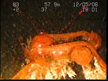
After the geophysical survey of wreck WA 1002, the site was targeted for survey by ROV. The wreck is an unidentified steamer, thought to have sunk during the First World War.
The interpretations of wreck WA1002 from the geophysical and ROV surveys were broadly in agreement with the dimensions of the wreck and the damage to the hull, identified from the geophysics data, were confirmed by the ROV survey. The lack of detail seen in the sidescan sonar data due to the wreck lying on its side could not be compensated for during the ROV survey as conditions prevented the ROV operating on the NW side of the wreck.
Only limited archaeological evidence could be collected during the survey. However, we know that the wreck is of remains of a riveted iron or steel steam or sailing vessel which was built at the end of the 19th or the beginning of the 20th century. Hall's patent stockless anchor was first used in 1886.
The general vessel dimensions are: LOA (length over all) 63m, BOA (breadth over all) 8-10m and D (depth in hold) around 5-6m.
Although difficult to determine from the available evidence, the general hull shape suggests a steamship rather than a sailing vessel.
The extensive damage to the hull amidships on the port side suggests how the vessel was lost. The hull is bent inward in this area, suggesting an impact perhaps caused by a shell, torpedo, or a collision with another ship.
Other Archives from Wrecks on the Seabed Round 2
Wrecks on the Seabed R2: Assessing Evaluating and Recording (Liberator)
Wrecks on the Seabed R2: Assessing Evaluating and Recording (U86)
