
Land East of Axminster, Devon. Geophysical Survey (OASIS ID: wardella2-274195)
Martin Railton, 2017. https://doi.org/10.5284/1043261. How to cite using this DOI
Data copyright © Wardell Armstrong Archaeology and Cultural Heritage unless otherwise stated
This work is licensed under the ADS Terms of Use and Access.

Primary contact
Clara
Dickinson
Geophysicist
Geophysics
Wardell Armstrong Archaeology and Cultural Heritage
Cocklakes Yard
Cunwhinton
Carlisle
Cumbria
CA4 0BG
England
Tel: +44 (0) 1228 564820
Resource identifiers
- ADS Collection: 2743
- DOI:https://doi.org/10.5284/1043261
- How to cite using this DOI
Introduction
In January 2017 Wardell Armstrong LLP (WA) undertook a geophysical survey of land east of Axminster, Devon. The survey was undertaken for The Crown Estate, to provide information to support a planning application for a residential development.
Although no known archaeological sites pre-dating the post medieval period are recorded within the proposed development area, it is recognised that there is the potential for as-yet unrecognised archaeological remains to survive at the site, including possible prehistoric and/or Romano-British remains, which may survive subsurface. Several post-medieval non-designated heritage assets are recorded within the site boundary in the Devon Historic Environment Record (HER), and are identified on historic maps of the site.
The objective of the geophysical survey was therefore to determine the presence/absence, nature and extent of potential archaeological features within the study area, and the presence/absence of any known modern features within the survey area, which may affect the results.
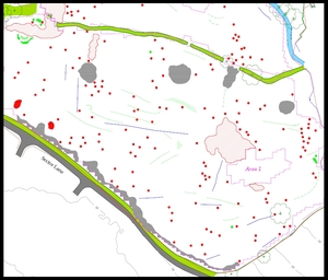
Geomagnetic survey was undertaken over the available land on a field by field basis, which comprised pasture at the time of the survey. Several geophysical anomalies detected were believed to be agricultural in nature, including possible plough furrows, land drains, lynchets, and former field boundaries. Topographic features were also detected, including possible evidence for clay/chalk extraction.
One of the archaeological features detected relates to a former rectangular building and three small enclosures, which are recorded in the Devon HER (MDV70579). Potential archaeological features have also been detected by the geophysical survey in several areas, including a pair of possible ring ditches or a barrow/cairn on the south side of the proposed development area.
