
Northumberland Bottom, Gravesend, Kent - Integrated Site Report
Museum of London Archaeology, 2009. (updated 2017) https://doi.org/10.5284/1044802. How to cite using this DOI
Data copyright © High Speed 1 unless otherwise stated
This work is licensed under the ADS Terms of Use and Access.

Primary contact
Stuart
Foreman
Senior Project Manager
Oxford Archaeology (South)
Janus House
Osney Mead
Oxford
OX2 0ES
UK
Tel: 01865 263800
Fax: 01865 793496
Resource identifiers
- ADS Collection: 2372
- DOI:https://doi.org/10.5284/1044802
- How to cite using this DOI

Introduction
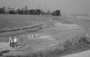
As part of an extensive programme of archaeological investigations carried out in advance of the construction of the Channel Tunnel Rail Link (CTRL), the Museum of London Archaeology Service was commissioned to undertake archaeological recording to the west of Northumberland Bottom, Southfleet, in Kent. The excavation areas lie c.1.5 km to the south-east of the Roman 'small town' at Springhead. The site lies alongside the A2 (Watling Street) between Hazells Farm and Wrotham Road, and is 1.75 km long (OS NGR 562536 171753 to 564123 171006). The investigations were carried out between June 1998 and May 2000, under the project management of Rail Link Engineering, on behalf of Union Railways (South) Limited (a subsidiary of London and Continental Railways Limited).
Earlier prehistoric evidence consists entirely of isolated funerary features (burials with no surviving indications of barrow mounds). The earliest of these was a late Neolithic/early Bronze Age double inhumation burial, with pottery beakers, found overlooking the Wrotham Road dry valley. A single cremation burial of early Bronze Age date was found in an upturned collared urn, overlooking the Downs Road dry valley, and a single middle to late Bronze Age cremation burial was found on high ground, roughly equidistant between Wrotham Road and Downs Road.
The earliest evidence for settlement occupation occurs in the earlier middle Iron Age and was concentrated near Hazells Farm. Evidence comprised a scattered group of five pits, a cooking pit, a water hole, a metalworking area consisting of bowl furnace bases and an area of possible animal pens. Evidence for later middle to late Iron Age activity extended over a much wider area, although indications of settlement activity in this period remain concentrated in the western half of the site. The Hazells Farm site continued in use, but there is evidence, in the form of enclosures, droveways, a pair of adjacent four-post structures and other features, that the rising ground to the east of Downs Road was increasingly exploited in this period.
In the late Iron Age or early Roman period an enclosed site of uncertain function was established c.300 m to the east of Downs Road. The enclosure developed alongside a minor track, and appears to have been abandoned before c AD 70. Associated features include a number of pits, several ovens or kilns, a hearth, a horse burial, a possible ritual pit deposit containing unburnt human bone, a well or deep quarry, and a cremation burial.
There were two foci of agricultural activity during the Roman period. The earliest, on the high ground to the west of the Wrotham Road dry valley, consisted of a group of adjoining rectangular enclosures bounded by banks and ditches. Activity at this location was mainly in the 1st century AD, extending into the 2nd century, and included evidence for cereal processing and domestic activity, including an oven. The second, later focus of Roman activity was located near the junction of Hazells Road and Downs Road. Features included the masonry foundations of a twin-chambered 'corn dryer' and elements of a field system, lying alongside a metalled track (probably a Roman precursor of Downs Road). The coin and ceramic assemblages from this site comprise the only exclusively late Roman (late 3rd to 4th century) site assemblages from the CTRL Section 1 project.
Two medieval sites, found on either side of Downs Road, were dated by ceramic evidence to the 12th/13th century. They perhaps form part of a medieval precursor of Hazells Farm. They comprised at least one large rectangular timber post-built building, located c. 200m east of the present farm, and traces of two circular domed clay ovens, lying alongside Hazells Road. Some 600 m to the east, on the higher ground between Downs Road and Wrotham Road, was a sequence of enclosures, with some indication of structures, ovens and rubbish pits, also dating from the 12th or early 13th century.
Evidence for more recent land-use includes a brick clamp dating from c 1450-1700, located c 100m north of Hazells Farm. A Second World War army camp and anti aircraft battery were recorded just to the west of Wrotham Road.
The fieldwork events covered by this report are:
- West of Northumberland Bottom (ARC WNB98) - Excavation
- Hazells Road Diversion Watching Brief - Area 330/350 (ARC HRD99) - Watching Brief
