
Images and Reports from Tulip Mews Watching Brief and Excavation, Heddon-on-the-Wall, Northumberland 2014-2021
Laura Caygill-Lowery, 2021. https://doi.org/10.5284/1085029. How to cite using this DOI
Data copyright © Megan Stoakley unless otherwise stated
This work is licensed under a Creative Commons Attribution 4.0 International License.

Primary contact
Wardell Armstrong Archaeology and Cultural Heritage
Marconi Road
Burgh Road Industrial Estate
Carlisle
Cumbria
CA2 7NA
England
Tel: +44 (0) 1228 550 575
Resource identifiers
- ADS Collection: 4021
- DOI:https://doi.org/10.5284/1085029
- How to cite using this DOI
Introduction
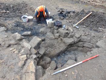
This collection comprises images and reports from a Watching Brief and Excavation on land at Tulip Mews, Heddon-on-the-Wall, Northumberland, commissioned and undertaken by Wardell Armstrong. During the Watching brief substantial remains of Hadrians Wall and a Medieval corn dryer were recorded and these led to targeted excavations.
Wardell Armstrong Archaeology was commissioned by Mr and Mrs Tulip to undertake an archaeological field evaluation and an archaeological watching brief on land at Tulip’s Haulage Yard, Heddon on the Wall, Northumberland (centred on NZ 13524 66948). This work was undertaken as part of a pre planning assessment prior to a proposed redevelopment programme, which will consist of the demolition of existing buildings and the construction of a new housing development and associated infrastructure. The site is located within an area of high archaeological sensitivity, being partially situated within the Frontiers of the Roman Empire World Heritage Site, which includes the Hadrian’s Wall Scheduled Monument and Vallum (SM 26086). As a result of the site’s location, Scheduled Monument consent had to be obtained and the project had to be carried out under guidance from Mike Collins, Inspector of Ancient Monuments (Hadrian’s Wall) for English Heritage.
The archaeological evaluation was undertaken over two days between the 8th and 9th December 2014. The evaluation involved the excavation of seven trenches, five of which measured 10m in length and 1.6m in width, with a further two trenches measuring 3m2.
Trenches 1, 2 and 4 were located along the northern boundary of Tulip’s Haulage Yard, on the proposed line of Hadrian’s Wall, whilst Trench 3 was located within the western half of Tulip’s Yard, between the proposed routes of Hadrian’s Wall and the vallum. Each of the four trenches were excavated to a maximum depth of 0.2m, revealing solid bedrock below topsoil and tarmac. Trench 5 was located towards the northeast corner of Tulip’s Yard, on the proposed line of Hadrian’s Wall and was excavated to a maximum depth of 0.9m, revealing natural drift geology below several modern levelling deposits. Trenches 6 and 7 were located within a small enclosed field, to the northeast of Tulip’s Yard and north of the proposed line of Hadrian’s Wall. Both trenches were excavated to a maximum depth of 0.7m, revealing natural drift geology below subsoil and topsoil.
No evidence for Hadrian’s Wall or any of its associated features were observed during the archaeological evaluation, suggesting that the wall has been completely destroyed at this point or that the actual route of the wall falls outside of its present projected line.
The watching brief was required to satisfy a condition of Scheduled Monument Consent (SMC ref: S00213496) and a condition of planning consent (Planning App. No. 18/01897/FUL), following advice provided by Mike Collins, Inspector of Ancient Monuments: Hadrian’s Wall, at Historic England and Karen Derham, Assistant County Archaeologist at Northumberland County Council.
The archaeological watching brief was undertaken between November 2018 and February 2020 and followed a previous programme of work undertaken in 2014. The current phase of works revealed the foundations of Hadrian’s Wall running across the site on an east southeast to west‐northwest alignment, in line with the extant remains of the Wall located to the east of the development area. The watching brief also revealed the southern edge of a large feature within the northeast corner of the site, believed to represent the remains of the Wall ditch located to the north of Hadrian’s Wall. The projected course of the Wall ditch was investigated further during an associated trial‐trench evaluation within the Military Road immediately north of the development site. Although the presence of the ditch could not be confirmed within the limited confines of the evaluation trenches, the abrupt termination of the bedrock pavement within one of the trenches and its complete absence within the others was conspicuous against the solid sandstone pavement observed either side of the Military Road.
Further remains revealed during the watching brief, included a stone‐lined kiln and the remains of structures associated with the former haulage yard. Although the kiln was located between the Wall ditch and the projected line of Hadrian’s Wall, dating evidence retrieved from the feature has highlighted that this was a later addition at the site, constructed during the medieval period.
