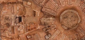
Data from Archaeological Recording at Former Curzon Street Station Yard, Birmingham, West Midlands, 2020-2023 (HS2 Phase One)
High Speed Two Ltd., MOLA Headland Infrastructure, 2023.
- HS2 Phase One: London to West Midlands Historic Environment Digital Archive
- Curated Collection: A Digital Archive of Britain's Railway History
Data copyright © High Speed Two Ltd. unless otherwise stated
This work is licensed under a The Open Government Licence (OGL).
Primary contact
High Speed Two Ltd.
2 Snowhill
Queensway
Birmingham
B4 6GA
United Kingdom
Tel: 08081 434 434
Resource identifiers
- ADS Collection: 4530
Introduction

This collection comprises of digital photographs, 3D models, CAD files, site records, and reports from archaeological recording at the former Curzon Street Station Yard carried out by MOLA Headland Infrastructure.
Due to the high-profile nature of the site, this collection also includes 3D models enhanced by the Archaeology Data Service to present a clearer overview of the structures related to the Roundhouse.
Project Summary
Between February 2020 and March 2021 Headland Archaeology (UK) Ltd. undertook archaeological mitigation on the site of the railway roundhouse at the former station yard at Curzon Street Station, Birmingham (Mitigation Area 1).
The archaeological fieldwork took place in across three phases, between February 2020 and March 2021.The mitigation area (Area 1) covered approximately 4200m2 and was located to the east of Birmingham city centre. Previous works here included a Desk Based Assessment, a programme of Geotechnical Trial Pitting and a Trial Trench Evaluation. The archaeological mitigation built upon these earlier works, revealing structures and deposits consistent with archival and cartographic records of the London and Birmingham Railways roundhouse (L&BR).
The London and Birmingham Railway (LB&R) Curzon Street Station opened to passengers in 1838. as the first railway terminus serving the centre of Birmingham, initially providing passenger services, alongside the Grand Junction Railway (GJR), which opened in 1839. The L&BR terminus was fronted by the extant grand ‘Principal Building’ which survives in situ, as do elements of the GJR neo-classical screen wall. The two stations were merged in 1846 to form the London and North Western Railway.
Built in 1837, the roundhouse at Curzon Street, the first of its kind in the world, stationed steam engines from the London and Birmingham, and later, the Grand Junction Rail Terminal. Contemporary sources describe it as a hexa-decagonal shaped building, with a pentagonal building on the front facing the London and Birmingham station. Within the main building was a central turntable around which radiated 16 lines on which the steam engines were housed and serviced, with enough room for 2 engines per line, or one engine with its tender. Beneath these lines were inspection pits to help with maintenance. Within the front building were offices, storerooms and workshops to facilitate servicing of the engines. Reference is also made to a communication from the front building to a subterranean coke vault, which opened out to and was supplied by the canal.
The site was converted into a single goods station, following the opening of Birmingham New Street Station in 1854, which operated until the 1960s. Various structures were demolished from 1860 to 1870 to allow for expansion, including demolition of the roundhouse, to make way for more lines, marking the beginning of the formal transition of the station from passenger to goods service.
The mitigation work revealed, not only the remains of the roundhouse, the base of its turntable and inspection bays, and the pentagonal building at its front; but also, its coke vault and communicating tunnel and evidence of phases of alteration as the roundhouse evolved to support the fast-moving development of engines and carriages.
Re-use Value Statement
The mitigation revealed the majority of the remains of the roundhouse. The foundation of the roundhouse and its front building were exposed, as well as the foundations of several internal features within them. The location and northwestern limit of the coke vault was uncovered and, although the full extent of it was not revealed, its location and the location of the tunnels and shafts that connected it to the roundhouse was confirmed. It is also clear that its full extent continues past the southern and western limits of the site. The extension on the eastern side of the roundhouse was also revealed, however its full extent continued beyond the eastern limits of the site. All the structures exposed on the site matched up well with historic plans, with few inconsistencies. This allowed for further analysis of the overall building and of certain features. The few inconsistences noted could mostly be seen to be the result of later alterations.


