A14 Cambridge to Huntingdon, Cambridgeshire; Conington Landscape Block

Alex Smith, David Bowsher, Jürgen van Wessel, Emma West, 2020. https://doi.org/10.5284/1081253. How to cite using this DOI

Digital Object Identifiers

Digital Object Identifiers (DOIs) are persistent identifiers which can be used to consistently and accurately reference digital objects and/or content. The DOIs provide a way for the ADS resources to be cited in a similar fashion to traditional scholarly materials. More information on DOIs at the ADS can be found on our help page.

Citing this DOI

The updated Crossref DOI Display guidelines recommend that DOIs should be displayed in the following format:

https://doi.org/10.5284/1081253
Sample Citation for this DOI

Alex Smith, David Bowsher, Jürgen van Wessel, Emma West (2020) A14 Cambridge to Huntingdon, Cambridgeshire; Conington Landscape Block [data-set]. York: Archaeology Data Service [distributor] https://doi.org/10.5284/1081253

Data copyright © Dr Alex Smith unless otherwise stated

This work is licensed under a Creative Commons Attribution 4.0 International License.
Creative Commons License


Highways England logo

Primary contact

Jürgen van Wessel
MOLA Headland Infrastructure
13 Jane Street
Edinburgh
EH6 5HE
UK

Send e-mail enquiry

Resource identifiers

Digital Object Identifiers

Digital Object Identifiers (DOIs) are persistent identifiers which can be used to consistently and accurately reference digital objects and/or content. The DOIs provide a way for the ADS resources to be cited in a similar fashion to traditional scholarly materials. More information on DOIs at the ADS can be found on our help page.

Citing this DOI

The updated Crossref DOI Display guidelines recommend that DOIs should be displayed in the following format:

https://doi.org/10.5284/1081253
Sample Citation for this DOI

Alex Smith, David Bowsher, Jürgen van Wessel, Emma West (2020) A14 Cambridge to Huntingdon, Cambridgeshire; Conington Landscape Block [data-set]. York: Archaeology Data Service [distributor] https://doi.org/10.5284/1081253

MOLA Headland Infrastructure logo

Introduction

A14 Cambridge to Huntingdon, Cambridgeshire; Conington Landscape Block

This is a child collection of the main A14 Cambridge to Huntingdon archaeological project archive. For the purposes of analysis, the various targeted excavation areas (TEAs) that formed the mitigation work have been grouped into eight Landscape Blocks. These have been defined due to the nature of the archaeology, their geographical location, and in some cases, their geology/topography.

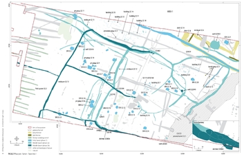
This child collection concerns the Conington Landscape Block. Conington comprises two TEAs (32 and 33), covering 21.4 hectares on clays to the north-east of Conington. Archaeological remains from Prehistoric, Iron Age, Roman and Saxon periods were encountered.

Image: Plan of the remains of Saxon Conington. The name means ‘King’s enclosure’, and we revealed 24 sunken-floored and post-built buildings and part of a Middle Saxon enclosed settlement, with a defined gateway;
© A14C2H courtesy of MOLA Headland Infrastructure


ADS logo
Data Org logo
University of York logo