Land south of Newlyn Road, St Buryan, Cornwall: Magnetometer and Earth Resistance Survey Report (OASIS ID: archaeol20-360834)

Kerry Donaldson, 2019. https://doi.org/10.5284/1057514. How to cite using this DOI

Digital Object Identifiers

Digital Object Identifiers (DOIs) are persistent identifiers which can be used to consistently and accurately reference digital objects and/or content. The DOIs provide a way for the ADS resources to be cited in a similar fashion to traditional scholarly materials. More information on DOIs at the ADS can be found on our help page.

Citing this DOI

The updated Crossref DOI Display guidelines recommend that DOIs should be displayed in the following format:

https://doi.org/10.5284/1057514
Sample Citation for this DOI

Kerry Donaldson (2019) Land south of Newlyn Road, St Buryan, Cornwall: Magnetometer and Earth Resistance Survey Report (OASIS ID: archaeol20-360834) [data-set]. York: Archaeology Data Service [distributor] https://doi.org/10.5284/1057514

Data copyright © Kerry Donaldson, David Sabin unless otherwise stated

This work is licensed under a Creative Commons Attribution 4.0 International License.
Creative Commons License


Archaeological Surveys Ltd logo

Primary contact

Archaeological Surveys Ltd
1 West Nolands
Nolands Road
Yatesbury
Calne
SN11 8YD
Wiltshire
Tel: +44 (0) 1249 814231

Send e-mail enquiry

Resource identifiers

Digital Object Identifiers

Digital Object Identifiers (DOIs) are persistent identifiers which can be used to consistently and accurately reference digital objects and/or content. The DOIs provide a way for the ADS resources to be cited in a similar fashion to traditional scholarly materials. More information on DOIs at the ADS can be found on our help page.

Citing this DOI

The updated Crossref DOI Display guidelines recommend that DOIs should be displayed in the following format:

https://doi.org/10.5284/1057514
Sample Citation for this DOI

Kerry Donaldson (2019) Land south of Newlyn Road, St Buryan, Cornwall: Magnetometer and Earth Resistance Survey Report (OASIS ID: archaeol20-360834) [data-set]. York: Archaeology Data Service [distributor] https://doi.org/10.5284/1057514

Introduction

St Buryan magnetometer survey Georeferenced greyscale image

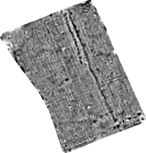
A geophysical survey, comprising both magnetometry and resistivity, was undertaken within a single field on the north eastern edge of St Buryan, Cornwall. The results indicate the presence of two possible former field boundaries parallel with the existing eastern and southern boundaries. A number of pit-like responses have also been located, with several in linear groups.


ADS logo
Data Org logo
University of York logo