Peter Tomkins takes us to Turkey, whilst Melissa Thomas whisks us away to sunny Greece -- just the thing for a cold winter's day. If you fancy something more cerebral, visit Amy Begier's virtual museum; it's just a finger-click away!
Liman Tepe is situated on the Turkish Aegean coast, not far from Izmir, in the Ishkele district of Urla. The site occupies the entirety of a headland opposite the island of Karantina, the site of classical Clazomenae. Originally the headland was more prominent, extending further into the sea. However, land reclamation, both natural and human, as well as a rise in sea-level since the earliest use of the site, have altered the geomorphology of the area considerably. In addition sporadic modern house construction and road building have helped erode or obscure parts of the site.
The hill of Liman Tepe is not a natural formation, but represents the successive accumulation of cultural layers over a considerable period of time. Recent excavations (since 1992), carried out as part of the Izmir Region Excavations and Research Project (IRERP), headed by Professor Hayat Erkanal, have shown it to be one of the longest inhabited sites on the Aegean coastline, with seven periods of occupation from the Late Chalcolithic (c.4500 BC) to the Classical period (c.fifth century BC).
In terms of architecture and associated stratigraphy, the uppermost layers, dating from the Classical period to the Late Bronze Age (LBA), have been much disturbed by later reuses of the site, as have those dating to the Chalcolithic, which is so far identifiable only through the analysis of redeposited cultural material. However, the layers corresponding to phases I-III of the Early Bronze Age (c.3200-2100 BC) are better preserved and reveal Liman Tepe to be a site of considerable importance in that period.
Figure 1 To see a full-size version of each of the following figures, click image.
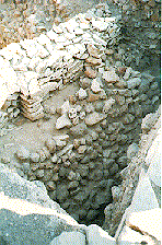
An EBI fortification system, consisting of a buttressed wall set on a stone glacis (see left), along with other associated features, represents one of the earliest examples of urban planning in the Aegean.
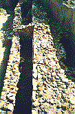
In EBII this arrangement is abandoned in favour of a
new fortification system on a much larger scale (see above). Excavations to the south of
the earlier wall have revealed a monumental city wall, preserved to a
height of 6 metres, protected by a large horse-shoe shaped bastion. This
system of wall and bastion has been traced all around the site. See plan
of site below.

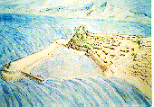
The large scale and the sophisticated construction technique used again testify to the importance of the site in this period. Although now submerged, a large 'extension' to the fortification system, 35 metres wide and 100 metres long, dated to the EBII period, has been traced to the north. This appears to have acted both as a bastion and as a breakwater, forming a sheltered and defended artificial harbour -- the oldest currently known in the Aegean.
Figure 3 � Izmir
Region Excavations and Research Project
1997
 Outside the fortified acropolis, the edge of a lower town of the same
period has been identified. Rough calculations of
the size of the EBII settlement, combining fortified acropolis and
lower town, suggest that Liman Tepe may have been even larger than Early
Bronze Age Troy.
Outside the fortified acropolis, the edge of a lower town of the same
period has been identified. Rough calculations of
the size of the EBII settlement, combining fortified acropolis and
lower town, suggest that Liman Tepe may have been even larger than Early
Bronze Age Troy.
Figure 4
� Izmir Region Excavations and Research Project 1997
 the importance of overseas contacts, suggested by the artificial harbour,
is confirmed by the discovery of ceramic vessels belonging to an assemblage
which has been termed the 'Kastri Group' by Aegean archaeologists. Although
previously rare in Anatolia, this assemblage occurs at several Aegean sites
and was originally dated to the beginning of the EBIII period. However,
restudy of material from the site of Ayia Irini on Kea has demonstrated an
association between 'Kastri Group' assemblages and 'sauceboats' -- normally
dated to EBII. Thus Liman Tepe, with its association of 'Kastri Group'
material and 'sauceboats', becomes important in terms of Aegean chronology
for the way in which it confirms this new interpretation.
the importance of overseas contacts, suggested by the artificial harbour,
is confirmed by the discovery of ceramic vessels belonging to an assemblage
which has been termed the 'Kastri Group' by Aegean archaeologists. Although
previously rare in Anatolia, this assemblage occurs at several Aegean sites
and was originally dated to the beginning of the EBIII period. However,
restudy of material from the site of Ayia Irini on Kea has demonstrated an
association between 'Kastri Group' assemblages and 'sauceboats' -- normally
dated to EBII. Thus Liman Tepe, with its association of 'Kastri Group'
material and 'sauceboats', becomes important in terms of Aegean chronology
for the way in which it confirms this new interpretation.
The presence of 'Kastri Group' material within a fortified settlement suggests an analogy with other sites in the Aegean, such as Panormos on Naxos and Kastri on Syros, where 'Kastri Group' material and fortifications are also paired. This appears to indicate that Liman Tepe belonged to the same cultural milieu as the Cyclades, north Crete and the coastal Greek mainland during this 'international' period of greater intensity of contact between the islands and the coastal hinterland of the Aegean. Crucially, archaeologists now are no longer forced to turn to Troy to help them understand the Anatolian context of the long identified relationship between Anatolia and the Early Bronze Age cultures of Greece, the Aegean islands and Crete. Thus, through the excavation of Liman Tepe, the picture of inter-regional contacts between Anatolia and the Aegean has not only lost some of its bias towards the northeast Aegean, but has also gained a new and dramatic level of resolution.
�Peter Tomkins 1997
Go to a review of the Aegean Symposium held near Liman Tepe.
Return to the top of the page.
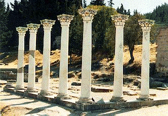
This photo shows part of the remains of the Asklepion on the Greek island of Kos. This beautiful site in the foothills is easily accessible by bus and is well maintained. Primarily, it is the site of the first hospital where Hypocrates is thought to have taught. Situated on three main terraces, linked by immense flights of steps, it is a massive site. As well as the Asklepion, the remains of a Roman bath house can be seen to one side of the bottom terrace. The pillars photographed are on the second terrace, and the ruins of other smaller buildings can be seen nearby. Although you have to pay to see the site, it is well worth it, both for the archaeological remains and the surrounding gardens.
�Melissa Thomas 1997
Return to the top of the page.

Designed by Amy Begier.
In this issue of assemblage we are proud to provide a link to 'The Virtual Gargoyle Museum' designed by Amy Begier of Le Moyne College. Attempting to augment traditional museum designs through the use of virtual images of gargoyles, gleaned from institutions around the world, she brings together a collection of material in one 'site' which would otherwise be impossible to visit 'in person'. Arguing that the Internet can be used to give world-wide public access in this manner, in contrast to the geographically rooted museum whose collections are static and only periodically arranged or elaborated through travelling exhibitions, she has designed a display around one particular theme � 'Medieval Culture as Evidenced by Gargoyles'.

Whilst recognising the importance of museums in providing the embodied experience of actually seeing and even touching artefacts, Amy Begier suggests that, when used in conjunction with traditional institutions, the virtual museum can provide a forum for particular exhibitions assembled from a much broader field than one or two institutions. She also uses the technology of the Internet to provide different routes through the museum. Drawing on recent museographic literature, she classifies museum visitors as either 'streakers' (visitors interested in a quick glance through the displays), 'strollers' (those who require a little more information about the displays and would be prepared to spend more time reading as well as looking at the images) and 'students' (who require the most background information and supplementary text). In this way, she allows the site visitor to specify which path they would like to take through the museum, according to level of interest and time to spend. There is ample opportunity to 'switch tracks' into the more lengthy routes of stroller or student, or to pass into the faster option of streaker.

This move into alternative forms of representation is important for archaeology, as it opens up the opportunity for people to gain access to material outside their own geographic areas. It should challenge museum specialists and designers, breaking the stranglehold often felt to exist over precisely which histories are 'told' to the public and how they are presented. Obviously, there is danger here as well as potential: in general, virtual museums will augment rather than replace traditional institutions. The Internet may be able to capture image and text but not materiality and thus the experiences gained from visiting real and virtual 'sites' will always be different. However, the thought and philosophy behind Amy Begier's work evidently enriches people's knowledge of this area of material culture whilst being aware of its limitations as well as advantages.
So go and browse !
About the Designer.
Amy L. Begier is an BA (English Literature) graduate of Le Moyne College (Syracuse, NY, USA): currently, I am employed in the design of the Anthropology Department's Web areas. I am also curator of 'Medieval Culture as Evidenced by Gargoyles' (visit the completed archaeology site as well! ). Truly in favour of the Internet as a tool for scholastic publication and academic learning, I plan to continue my work. By December, a site will exist that simulates an archaeological dig. Further, this site will provide basic information on archaeology, e.g. what archaeologists do, and how they do it. And, of course, my interest in and pursuit of the medieval world is a constant endeavour.
© Melanie Giles 1997
 Go on, e-mail assemblage today!

| 
| 
|

| 
| 
|

| 
| 
|

| 
| 
|
© assemblage 1997
