
by
M. Dymond
The Gardom's Edge Archaeology Project seeks to interpret an ancient landscape on the eastern moors of the Peak District National Park, Derbyshire. It is a collaborative project, involving the Archaeology Service of the Peak National Park Authority and the Department of Archaeology and Prehistory at the University of Sheffield.
A central theme of the project has been to raise public awareness of the remains of the human past that survive in the Peak National Park as well as of archaeology in general. This necessitates making the archaeological excavations open to the public. The excavations form part of a broader programme aimed at making archaeology accessible to a wider audience, through local talks, site tours, local participation in the excavations, and, this year, the publication of excavation reports on the Worldwide Web.
The project is aimed at developing an understanding of the moorland landscape through the
application of a variety of techniques, including survey, excavation, test-pitting and landscape
art. A programme of conservation has also been undertaken, to protect the prehistoric rock
art, which has rapidly deteriorated over the last few decades as a result of weathering.
As this year's season progressed, the information generated from the excavation was
disseminated to the public through the local media and tourist offices. This was to encourage a
greater awareness and understanding of the archaeology within the Park, thus increasing
public interest in archaeology. It was achieved through adopting two parallel strategies, one
aimed at adults, the other at schools: these facilitated access to the excavation and provided
opportunities for children and adults to explore how the past is discovered and 'created', or
interpreted. The programme consisted of two parts. First, the public was invited to visit the excavations and was shown around both the current
excavations and those from previous years by archaeologists who acted as guides. At
weekends, comprehensive archaeological tours were organised to explore both the
excavations and the wider prehistoric and historic landscapes in the vicinity. Within both, we
aimed at conveying both the wealth of remains and the great depth of time these represent. Second, an extensive school programme was established and ten primary schools each season
were invited to visit the excavations as part of a geography project, in which the relationship
between people and the environment was explored. Since the project's inception in 1995, 35
classes have visited our excavations, amounting to almost one thousand seven to twelve-year-old pupils. The schools invited have come from very different areas: small rural schools from
within the Peak District National Park and schools from the conurbations of Chesterfield and
Sheffield. The schools education programme was supported by the Peak National Park
Authority who organised the visits and co-ordinated the programme. To support their visits,
schools were also provided with a specially written Teacher's Pack that provided teaching
material and information both on the Park and on the archaeology of Gardom's Edge. The stated aim for the schools' visits was to provide an opportunity both for pupils and
teachers to see archaeology at work. But it was equally important to teach pupils some of the
skills of landscape archaeology. These stress observation and identification of the surviving
prehistoric and historic remains, and encourage pupils to make their own interpretations. To encourage schools to visit Gardom's Edge, the education programme needed to
incorporate archaeology into the schools curriculum. Archaeology possesses a unique
perspective for emphasising how people interact with their immediate natural environment. It
seeks to address such complex relationships through an exploration of how people change
landscapes, manifest in structures and remains. The extensive archaeological and historical
remains on Gardom's Edge were thus taught through a theme that articulated change, focusing
on how people in the past assimilated, transformed, and exploited this particular landscape. The
unique fossilised archaeological remains allowed pupils to identify structures and features that
represent almost 5000 years of continuous human habitation. Using the theme of
environmental change as a consequence of human intervention, archaeology can demonstrate
the human impact on the natural world, thereby informing pupils about the temporal
dimensions embedded in all landscapes. Pupils began their visit by following a 'time trail' that focused on the movement of walking
from the valley, which is inhabited today, up to the moors which were inhabited in prehistory
(and used in the medieval period). This activity was adopted to convey to the pupils a sense of
historic depth, through linking their journey with a sense of 'going back in time'. The trail
incorporated some of the remains left by the recent historic past. Sites visited included a
disused and collapsed nineteenth-century coal mine shaft, a monument commemorating
Nelson's victory at the Battle of Trafalgar in 1805, a ruined post-medieval barn dating to
between 1799 and 1826, and extensive dry-stone walling relating to the enclosure of common
land after the 1826 Enclosure Award. Activities were organised to take place at these sites,
with emphasis on observation and explanation. Once up on the moor, the pupils were taught to identify the prehistoric remains�principally
clearance cairns and field systems that date to the Bronze Age. The pupils were then led to the
excavations at which structured discourse directed pupils initially to identify the tasks taking
place and the nature of 'digging'. This led to opportunities for questions, and pupils were
encouraged to interpret the remains being uncovered by the archaeologists. In the afternoon, pupils were introduced to a variety of activities that encompassed
archaeological practice, drawing and mapping, and archaeological interpretation (see Figure 1).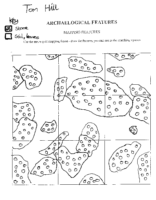
Figure 1. This depicts a narrative of what, from the information they were given, the students believed had occurred in the enclosure (read left to right).
The prehistoric rock art provided a focus for some of these activities: pupils were encouraged to interpret the design for themselves, and think about the different meanings it may have had. In order to convey the past as 'alien' or 'other', pupils played the Barter Game in the Neolithic enclosure. This activity was used to represent one of the many activities that archaeologists believe may have occurred here in the past. Classes were divided up into small groups, which represented local communities. These groups were then set the task of securing particular items for their communities who had sent them, including food, pottery, flint, or other stone tools. Pupils then bartered the products they had been given for those they needed.
Pupils were than asked to draw in chalk on some of the boulders in the Neolithic enclosure. They were encouraged to think how the prehistoric rock art and enclosure might have been used, and to express these ideas through their drawings. Some drew abstract images, others figurative drawings, and the content spanned pictures representing feasting and trading at the enclosure, to a pictorial record of a pupil's journey to Gardom's Edge (see Figures 2, 3, 4, and 5).
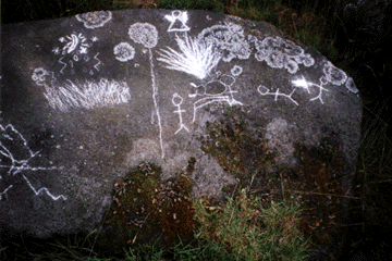
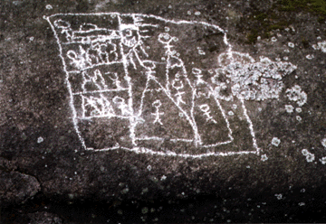


Figures 2-5. Depictions of the journey to Gardom's Edge and ideas of what took place in the enclosure there. Note the time dimension in Figure 3, upper right, shown by the human figure at the bottom and top of the edge, depicted as a stylised mountain.
Finally, the Bronze Age/Early Iron Age round house excavated in 1995-96 provided a unique on-site 'context' for introducing pupils to some of the inferences that archaeologists draw from the material remains. Here pupils were asked to compare and contrast the use of space within a roundhouse to their own square or rectangular homes (see Figure 6).
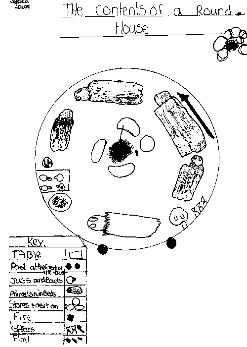
Figure 6. A student's hypothetical plan of the interior of a Bronze Age roundhouse.
On the return journey, classes stopped at a ring-cairn. These monuments are believed to date to about 2000 BC, and were probably built by small communities who farmed in the immediate vicinity, so as to provide a communal focus for various agricultural celebrations. Here the last activity focused on role play. A story was begun by an archaeologist, which drew upon our current interpretation of these sites, and pupils were invited to add a few words or sentences. Thus a story was constructed by moving around the pupils who stood on the ring-cairn.
To explore further the difficulty and excitement inherent in establishing connections between the past and our present, we experimented with presenting the archaeology through multiple interpretations. The excavation of the Neolithic causewayed enclosure offered an excellent opportunity for me and the other schools guide, Anwyn Cooper, to present to different classes two different interpretations of how the enclosure bank was constructed and used. Both interpretations used the same evidence, which lay in front of the pupils. They were asked which they believed to be the most likely explanation. This exercise allowed pupils to see how archaeologists construct an understanding of the past and to see the basis on which they do so. It also empowered them to select the interpretation of the causewayed enclosure that they preferred. Archaeologists have come to recognise that interpretation is characterised by multiplicity. The past is always read through the concerns or preoccupations of the present.
The schools programme actively engaged in encouraging pupils to make sense of the past for themselves. We aimed to demonstrate how archaeology recovers and helps create the past, and also to inform pupils of the skills involved in an archaeology that focuses on whole landscapes rather than individual sites.
The visits by schools were quickly followed up with visits to schools a week later. Classes were informed of the latest developments on site, and pupils were encouraged to ask questions about how the excavations were proceeding. Work was introduced that emphasised 'making sense' of the excavations they had seen in terms of what stories they could tell. In support of this interpretative emphasis, whole class and group discussions were initiated. These were focused on several important issues or questions: where should next year's excavations on Gardom's Edge be situated? where should the finds be exhibited? should we continue to excavate? The whole class was then engaged in discussing how the Peak National Park Authority could present the archaeology and landscape at Gardom's Edge to the public.
The education programme has helped to foster a greater awareness of archaeology amongst primary-school pupils, but it also had the knock-on effect of encouraging parents to visit the excavations at the insistence of their children. If archaeology is to become more accessible and perhaps accountable, then its presentation, in all its interpretative uncertainty, can be no better conveyed than through the curiosity and enthusiasm manifested amongst a group of thirty primary school pupils.
About the author
Mike Dymond is a PhD
student of archaeology and prehistory at the University of Sheffield. He
is researching how children interpret the past through artefacts.
Copyright © M. Dymond 1998


Copyright © assemblage 1998