
ARCHAIC SETTLEMENT AND EARLY ROMAN COLONISATION OF THE LEPINE FOOTHILLS
M. van Leusen, University of Groningen
ARCHAIC SETTLEMENT AND EARLY ROMAN COLONISATION OF THE LEPINE FOOTHILLS
M. van Leusen, University of Groningen
INTRODUCTION
In April 1998 a small team from the University of Groningen conducted a field walking survey of part of the Lepine foothills, located in south Lazio (an hour's drive south of Rome). Part of the larger Regional Pathways to Complexity (RPC) project conducted jointly with the Free University of Amsterdam, this and future field work aims to answer current research questions relating to urbanisation and colonisation in protohistoric Italy, and to provide a yardstick against which to measure earlier work. The part of south Lazio known as the Pontine Region is one of three regions studied in the RPC project.
Attema most recently studied the protohistoric and early Roman settlement of the Pontine Region (Attema 1993, 1996, in prep.). The current view is that nucleated settlement seems to have originated in the Iron Age around the Alban Lake (with such nuclei as Ardea, Lanuvium, and Velletri) and to have developed slightly later on the higher ground around the Pontine plain proper (at such sites as Satricum, Cisterna di Latina, and Caracupa/Valvisciolo). However, many of the Archaic nucleated settlements in the latter area disappeared sometime during the later sixth century BC (the late Archaic Period), and seemed to be replaced after 500 BC (the post-Archaic) by small dispersed settlement only found in the volcanic tuff hills (Attema 1993: 122).

In contrast, Attema reports that Iron Age and Archaic materials in the colluvial plain deposits are very poorly represented, and no discrete protohistoric sites were identified at all in the Cori survey transect, though protohistoric pottery was found among the predominantly Roman artefacts, indicating continuity at some sites (Attema 1993: 117-8). A field walking survey south of Sermoneta yielded very little early material on the plain, where conditions must have been generally unfavourable for settlement. Again, in a similar survey near Sezze, finds from the Iron Age and early Archaic were absent (Attema, in prep.). Whereas colluviation may be implicated in the decreasing visibility of archaeological remains on the plains, we would not expect this to have such an impact on the western slopes of the Lepine mountains. Since 1993, several field walking survey campaigns have been conducted on these slopes in order to establish whether this view is correct.
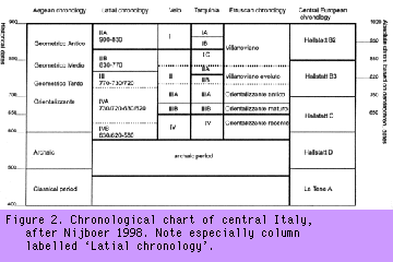
The regional chronology for the current study departs from the generally accepted chronology in substituting a post-Archaic Period (roughly 500-350 BC) for the early Roman Republican period (see Figure 2), as archaeological indicators for Republican colonisation (colonies, villas, amphora-like pottery, black glaze) appear in the area only after 350 BC. Other important aspects of the regional chronology are the shift from Late Iron Age orientalising pottery styles (seventh century BC) to Archaic red pottery, and the shift (around 500-490 BC) from the latter to post-Archaic pottery styles, which is visible in the increased production of pale and orange-firing pottery, tiles made from more highly purified clay and the introduction of more substantial building styles with heavier roof tiles. It should be noted here, in the absence of excavations, that site dating does not permit us in most cases to determine whether a site was occupied in the post-Archaic Period, the early Republic, or both.
THE LOWER LEPINE SLOPES
 According to the
established view, there was very little settlement-related activity on
the Lepine slopes until the later fourth century BC, when a system of
Roman Republican villas appeared, related to the new colonies of Cora,
Norba, and Setia (q.v. Attema 1993: 233 ff.). This villa system
apparently represents a clean break with what came before, not just
because of the change in building methods and pottery styles and
techniques, but also because large-scale olive and vine cultivation
began to be practised. The period from 500 to 350 BC apparently brought
an abrupt end to the evolution of the Archaic landscape -- most likely
due to the troubles associated with the Volsci wars -- and is an
archaeological 'dark age'.
According to the
established view, there was very little settlement-related activity on
the Lepine slopes until the later fourth century BC, when a system of
Roman Republican villas appeared, related to the new colonies of Cora,
Norba, and Setia (q.v. Attema 1993: 233 ff.). This villa system
apparently represents a clean break with what came before, not just
because of the change in building methods and pottery styles and
techniques, but also because large-scale olive and vine cultivation
began to be practised. The period from 500 to 350 BC apparently brought
an abrupt end to the evolution of the Archaic landscape -- most likely
due to the troubles associated with the Volsci wars -- and is an
archaeological 'dark age'.
Earlier surveys
Paola Vittucci
Brandizzi's topographic survey in the area of Cori and Artena (some 10
by 15 kilometres), conducted in the early 1960s, was published in the
Forma Italiae series (Vittucci 1968). Little further work was done until
the late 1980s when, in the course of the Pontine Region Project at
Groningen University, field walking surveys were conducted in adjoining
parts of the Lepine footslopes near Norba, Cori, Sermoneta, and Sezze,
and at the Archaic proto-urban site of Valvisciolo (see Figure 1). This
work was reported by Attema (1993). The most recent work, leading up
to the 1998 survey near Ninfa, was done near Sezze (Attema, in prep.)
and Norba (King 1995). The goal of these two surveys was to locate and
assess sites belonging to a hypothetical system of colonial Roman
Republican villas, as suggested by Attema (1993: 233 ff. and Fig. 148;
see Figure 4). Generally, these sites are easy to detect in the
landscape not only by concentrations of pottery and tile, but also by
their platforms' retaining walls and associated cisterns, constructed in
polygonal dry stone and (later) cemented masonry. These have withstood
the ravages of time. The villas figure prominently in Vittucci's early
topographic and 'desktop' survey because of their durability.
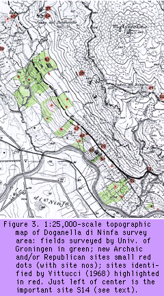
Vittucci's (1968) map and description of sites in the Cori-Norba area relies heavily on the compilation of contemporary archaeological records and following up reports by local inhabitants. It is, therefore, no surprise that she reports no prehistoric activity at all and instead concentrates on mapping evidence of Roman rural villa architecture (cisternae, platform retaining walls, field terracing) and infrastructure (the pedemontana road, about which more later). The table below gives her descriptions, with 'Site ID' referring to the numbers in Figure 3.
| Site ID | Description |
| 33 | villa; wall in opus caementicium; many pieces of tile and amphora, especially to the south of the wall; reticulate bricks. |
| 34 | terracing in second polygonal style. |
| 35 | terracing in second polygonal style. |
| 36 | cisterna in opus caementicium and wall in second polygonal style; similar structures are supposed to have existed nearby, but may have been built over; some remains of coarse 'grossolana' sherds in the area. |
| 37 | villa platform c. four metres high in second polygonal style and terracing below it; covered entrance to platform; some ceramics and tile found; lead pipe reportedly found nearby in 1915 but later lost. |
| 38 | terracing; polygonal walls, c. 65 metres remaining of a longer stretch that was recently destroyed. |
| 39 | tile; marble architectural remains; remains of tombe a cappuccina [type of inhumation tomb]; site recently disturbed by viticulture. |
| 40 | top and bottom walls of pedemontana road in polygonal style. |
| 41 | villa rustica (cisterna in tuff blocks, terracing in third polygonal style); around it numerous tile, imbrex, and vase fragments. |
| 42 | cisterna in opus caementicium; some remains of polygonal-style terracing below. |
| 43 | top and bottom walls of pedemontana, c. six metres wide, just below the modern path. |
| 44 | long stretch of pedemontana walls, curving in order to cross a small gulley. |
| 45 | villa (three-sided polygonal wall in third style, small cisterna in opus caementicium), c. 20 by 5 by 2.5 metres; numerous limestone architectural fragments reported; reticulate wall reportedly found during construction of nearby house. |
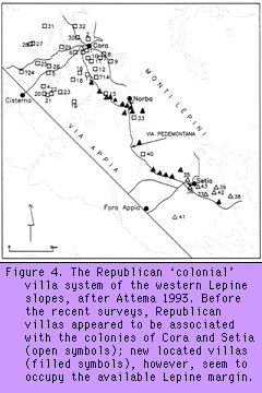
Attema and his colleagues surveyed the Lepine foothills just south and south-east of Norba on two occasions, first as part of the 1987 Norba transect survey (see Figure 1), and again in 1995 in order further to map possible Roman sites along the pedemontana. Attema noted that, as in Vittucci's survey, 'Roman scatters [are] in all cases related to architectural remains, either polygonal masonry, opus caementicium finished with opus (semi) reticulatum or a combination of both. The latter are an indication of continued use of the site from early Republican times into the late Republican and early Imperial period' (Attema, pers. comm.) The evidence of the protohistoric period they gathered, however, indicated that settlement began in the later Iron Age and intensified in the Archaic with both a proto-urban nucleus (Valvisciolo) and a dense distribution of smaller sites developing. Most of the Republican villas and other Roman sites seem to have developed out of these earlier Archaic settlements, and none of the sites appears to have been occupied after the early Empire.
Attema also noted that sites identified as Roman villas are distributed
fairly regularly, about one kilometre apart, along the lower slope
deposits, suggesting the possibility of a 'villa colonisation' of the
landscape, directed from the colonial towns. One Republican villa was
unusual in that it is situated much further upslope inside the
Valvisciolo gap; Attema suggests this could indicate that there was some
level of hierarchical organisation to the rural villa system, and this
site could be an example of a 'top-level' villa.
The Doganella di Ninfa survey
In April 1998, a new team led by Attema, which included the author, conducted a
further survey of the lower Lepine slopes, this time in the Doganella di
Ninfa area, which directly adjoins the area surveyed in 1995. This
survey area, of about 5 kilometres by 750 metres and dominated by the
Monte Arrestino massif (862 metres above sea level), is bounded by the
Canale delle Acque Alte (Canale Mussolini) and Fosso del Cavone on the
west and north sides, and by the steep uncultivated
slopes and cliffs of the Lepine hills to the east. It is further bounded to the south by the area surveyed in 1995, and to the north by the Cori gap (see Figure 4).
Nowadays it consists mostly of large and small fields with olive trees,
with smaller areas devoted to fruit trees, viticulture, and grazing. The
slopes are cut in two or three places by intermittent streams, and
drainage at the foot of the slope is from north-west to south-east, due
to the elongated tuff-hill relief there. The area is dotted with small
farming cabins and, increasingly, with modern houses. The two main
rubble-metalled tracks running through the area perpendicular to the
slopes, as well as many minor paths, are in heavy use, and we saw much
evidence of machinery working fields in order to remove stones. This
included the removal of both terrace walls and remains of Roman
architecture. Increasingly, the steeper slopes are also cleared,
ploughed, and enclosed.
The team systematically surveyed a total of 27 fields and discovered or reconfirmed the presence of 20 sites. Figure 4 shows the locations of these fields and sites on a topographical background. Although the stated purpose of the survey was to map further parts of the Roman system of platform villas, associated with olive cultivation and the strategic colonies of Setia and Norba and connected by the pedemontana road, most of the Ninfa area proved to be rich in Archaic finds, with Roman Republican sites (often without any platform walls) generally occurring in the same locations. This confirmed that the results of the 1995 survey should not be seen as exceptional and that the Romans could not be seen as colonisers, in the sense that they brought under cultivation a landscape previously used only marginally. Instead, a fairly dense and possibly differentiated Archaic settlement pattern is present, which will force an adjustment of current views regarding the settlement history of the area.
The table below gives only the preliminary site identifications resulting from the survey. A detailed report and full analysis will appear elsewhere.
| Site no | Description |
| S2 | diffuse scatter; early Archaic. |
| S4 | Archaic farm - Republican platform villa; some Iron Age material present. |
| S5 | small scatter of Archaic sherds. |
| S6 | Archaic - Republican farm. |
| S7 | Archaic - Republican farm; some Iron Age material present. |
| S8 | Archaic - Republican farm. |
| S9 | Archaic farm - Republican platform villa; some Iron Age material present. |
| S10 | Archaic farm - Republican platform villa. |
| S11 | diffuse scatter; Archaic. |
| S12 | Iron Age ceramic scatter; no precise date available yet. |
| S13 | tomba a cappucina, Republican. |
| S14 | Archaic - Republican hamlet. |
| S15 | Archaic - Republican farm. |
| S16 | small scatter of Archaic and post-Archaic sherds. |
| S17 | scatter of Archaic and post-Archaic sherds. |
| S18 | Archaic and Republican ceramic scatter. |
| S20 | Archaic - Republican farm. |
| S21 | Archaic - Republican farm. |
Settlement history
Ceramic finds were classified according to fabric, ware,
and form. Although many of the pottery and tile finds cannot be dated
very closely, it is possible here to present a preliminary rough
chronological description of the settlement history of the Ninfa slopes.
The earliest datable material from the area is a red-firing impasto from the early Iron Age, which occurs as off-site material on a possibly levelled tuff ridge near the Lepine slopes proper. No material from the middle Iron Age was found. The late Iron Age (phases IVA and IVB, dating to about 730-630 BC and 630-580 BC, respectively) is represented, in phase IVA, by common red-slip ware occurring in very low numbers in the southern half of the study area and, in phase IVB, by a coarse red-firing fabric with ferromanganese temper found at many locations. It would seem, then, that Late Iron Age sites occur about every kilometre, with occasional single finds in between. The regular, if not very dense, distribution suggests that, as in the 1995 survey area, we may trace the beginnings of the exploitation and settlement of the Lepine foothills in the Ninfa area to this period, and in particular to the IVB phase.
The Archaic Period (580-490
BC) is represented in the study area by coarse red-firing ceramics with
augite temper, occurring in thick (dolium) and thin (olla) forms. The
latter may also date to the post-Archaic, but as the distribution
pattern and even the densities in which both forms occur are very
similar, this has no effect on the settlement history of the area. The
crude red augite-tempered pottery, in fact, occurs at all sites and
fields surveyed and therefore indicates a strong intensification of
settlement and land use in comparison with the previous period (even
after correcting for the fact that the Archaic period is twice as long
as Late Iron Age phase IVB).
The post-Archaic Period (490-350 BC, following Attema 1993) is less well represented by the finds but must be represented by pale and orange-firing augite-tempered crude pottery (mostly tile), and by orange-firing coarse ware. We find such materials occurring in fairly high numbers in most of the area, probably as off-site material. Nearly all of the Archaic sites also contain many of these post-Archaic ceramics, which suggests that previous land use patterns continued. This interpretation is also supported by the fact that the lion's share of the post-Archaic materials consists of the highly visible tile, whereas the orange coarse ware occurs in comparable densities to the Archaic coarse ware. Therefore, we must assume that the only differences between the two periods are an increased use of tile for roofing and a shift in pottery production technology toward a more controlled process resulting in lighter-coloured products consisting of a more highly purified clay matrix and an augite temper. Presumably, the shift in roofing construction indicates a more general change in Latial building construction. The lack of more dramatic visible changes in the archaeological record is remarkable, since this is a period of historically attested Volscian inroads.
The Middle and Late Roman Republican Periods (350-50 BC) are represented in the finds by a growing diversity of pottery technology (depurated, reduced, and hard wares) and styles, by the use of lava temper in tiles, and by the introduction of fine wares, such as that with black glaze. These materials occur at all of the larger sites occupied in the previous post-Archaic period, but a look at the details reveals that there were changes in emphasis nonetheless; some sites seem to have been abandoned, while others show either a sharp reduction or growth in the number of finds. Also, the period we are dealing with has a 'stratigraphic advantage' with respect to the post-Archaic, and is more than twice as long as it, and the absolute number of finds must be interpreted with this in mind. It seems, then, that we must interpret the finds from the Republican Period as indicating, not a growth in density of occupation, but rather a concentration of settlement onto a lesser number of larger farm sites. Indeed, we found such platforms at five of the sites, at least, supporting in part Attema's (1993) suggestion that this period saw the establishment of a system of rural platform villas.
We found very little evidence for the continued use of the area into the Empire, other than the occurrence of small pieces of terra sigillata and African red-slip ware at some of the Republican sites, again echoing the results of the 1995 survey. Coupled with the fact that we could not identify any fully Imperial or early Medieval sites, this argues for the assumption that the area was essentially abandoned by the early Empire. However, with Barker (1996: 67), we should exercise caution for the later period: 'The failure of many field surveys to locate early Medieval settlement effectively is ... the predictable outcome of a combination of negative factors: a much sparser population, a nucleated settlement system, greater use of perishable materials in buildings, and of poorly made pottery that is much less precisely dated than Roman ceramics'.
DISCUSSION
In all, the Doganella di Ninfa survey revealed 16 new site locations, ranging in type from a single probable tomba a cappuccina to an Archaic and Republican hamlet, and in date from the early Iron Age to the late Republic. No sites dating definitely to the Empire or to the Middle Ages were found. Perhaps most importantly, the whole of the western Lepine slopes, between about 60 and 150 metres above sea level (asl), appears to have been intensively used in the Archaic and post-Archaic Periods.
The Archaic settlement system
There is now some evidence for three levels of
settlement among Archaic sites on the western Lepine slopes. Between the
'top' level represented by the single large proto-urban site of
Caracupa/Valvisciolo and the 'bottom' level of the multitude of small
and scattered single-family farmsteads, site S14 represents a middle-level of aggregated settlement consisting of a few households, lacking
any evidence of centralised or 'proto-urban' function -- a hamlet.
This system was decapitated with the abandonment of Caracupa/Valvisciolo at the end of the Archaic Period. It may be that the incipient urbanisation of the Pontine region, referred to in the introduction, was reversed by the end of the Archaic as circumstances became less favourable through sporadic warfare, and the inhabitants resettled into smaller and more easily defended sites on the Lepine scarp. It would have been the latter that were targeted for the early (i.e. early fifth-century) Roman colonisation reported by the early historians.
Continuity in the post-Archaic?
The existence and nature of any Roman colonisation on
the western Lepine slopes is predicated to a large extent on the
presence or absence of a post-Archaic 'gap' in the settlement history of
the area -- the period called a 'dark age' by Attema (1993: 17).
However, if there was no settlement continuity, and the area had been
more or less deserted for five or six generations, then how is it
possible that the Republican farms are all located on Archaic settlement
sites? Certainly, dispersed post-Archaic settlement existed in the
Cisterna di Latina area, and there is no reason to deny it to the
foothills. We must, therefore, assume that there was settlement
continuity throughout the post-Archaic, and we must ask what the nature
of the change was, from slight buildings and thick augite-tempered
pottery in the Archaic Period to tile-roofed platform buildings with
cisterns and amphorae and fine pottery in the Republic. Was the
indigenous population moved away to make place for the new settlers,
whose farms were constructed according to some colonial base plan? Or
have the changes visible in the archaeological record occurred over a
longer period, allowing indigenous farmers to take on certain Latin (and
later, Roman) habits? Certainly, the very fact that ceramic dating
becomes very unclear during these centuries points to the lack of
recognisable development, and therefore to a disruption in normal
production and cultural exchange, which we may ascribe to the Volsci
wars.
The Republican 'colonial' villa system
Roman style 'urbanisation' only begins in the middle of
the fourth century BC with the establishment of formal coloniae at Cori,
Norba, Circeo, Terracina, and Setia. But the establishment of these
colonies did not take place in a vacuum. Control over the landscape and
its inhabitants also took the form of a rural colonisation of which the
villas are the most reliable evidence. The characteristic linking both
parts of the system is the use of polygonal walls. Attema's villa hypothesis (Attema 1993: 233
ff.) suggests that we may be able to distinguish three groups among the villas
found during the survey:
Evidence for the hierarchical organisation of the Roman Republican villa system is intriguing, but the distinction between the three levels will need verification by excavation, which could uncover functional differences between them. The hypothesis that early platform villas were built in a communal colonial effort and are located at regular intervals of about one kilometre could be further tested in future surveys and by careful comparison of the dimensions and masonry styles of the platform architecture.
Burial
Very little evidence for burial was found in any of the
surveys of the area. The nearest known Archaic necropolis is that of
Valvisciolo, and Republican necropolises are, of course, associated with
the Roman colonies. Possible tombe a cappuccina (inhumation burials) were
found in two locations some one kilometre apart, but it seems reasonable
to assume that burial normally took place at the edges of each
settlement's core area. Many more graves are therefore likely to exist
in the area, but they are very hard to detect from surface survey alone,
as the remains of such burials could easily go unnoticed amidst the
general off-site noise surrounding the Republican sites in the area. No
evidence was found for the existence of a burial ground on the higher
slopes of Monte Arrestino.
Spacing and communication
Although the pedemontana is generally thought of as a
Roman construction, communicating with the towns and villas built in the
middle of the fourth century, it seems likely that its route and many
lesser routes besides had been in constant use since at least the early
Archaic Period, connecting the large proto-urban settlements, while
avoiding the difficult and unhealthy terrain below. There would
certainly also have been communication lines with settlements (both
Archaic and Republican) on the Lepine scarp, similar to paths that are
still in use today, if not identical with them.
King (1995: 12) suggests that sites are spaced at regular distances along a road (approximately 500 metres, judging from her map). Such regularity could also be observed in the Ninfa area, with villa sites continuing from south to north along the presumed line of the pedemontana. The distance between large platform villas is consistently around 1000 metres here, but if we include the other sites yielding Republican material, the typical distance between sites again becomes 500 metres or less.
Altitude and slope
The natural conditions in the area mean that, without
modern farming machinery, only part of the typical slope could have been
used for farming and olive cultivation. Archaic and Roman Republican
sites are generally located at an altitude between 60 and 150 metres asl.
The soil becomes too steep and stony above this point to be used for
anything but extensive grazing by goats and horses, as is currently the
case. It is less clear that conditions are unsuitable for farming at the
lower end of the slope, but we may suggest two reasons not to situate
farms lower than 50 metres asl: firstly, the view over the Pontine and
Alban areas is dramatically reduced, and secondly, the heavy clay soil
may not have been workable throughout the year.
Slope does seem to be a factor affecting many sites; there is a preference for flatter areas (which, of course, correlate with elevation) and often such areas appear to have been human-made already in the Archaic Period. Platform villas also occur on steeper slopes and, in the case of villa Vittucci 46, significant walls had to be constructed to retain the villa platform (over four metres high). The occupants were rewarded with a magnificent view ranging all the way from the Monte Circeo and Monti Ausoni in the south to the Alban volcano in the north -- a distance of more than 20 kilometres both ways! We suggest that this villa was a member of the 'controlling' group mentioned above.
Sources of water
Distance to surface water is not clearly a locational
factor, though recent changes made to the landscape mean that this
aspect must be studied further. Currently, wells have water at about one
metre below the surface, which means that early farmers were certainly
not restricted to living near surface water. Unfortunately, it is not
possible to date any of the numerous wells in the area that are not
obviously modern.
ACKNOWLEDGEMENTS
I would like to thank the students who surveyed the Ninfa area with me for their assistance and Rhiannon Gaskell for uncovering many inconsistencies in the survey administration while writing up her report of Archaic finds.
Copyright © M. van Leusen 1998


Copyright © assemblage 1998