Conceptual Background
It is probably fair to say that prehistorians' own perception of the task of reconstructing the lifeways and thought-worlds of their chosen societies is that it is in some sense ennobled and elevated to a higher intellectual plane by their total reliance on aspects of material culture. This has in effect forced them to establish theoretical models of societal and cultural development in a way that, they might argue, their medieval colleagues would simply not recognise. Documents, then, are for wimps, and it is no coincidence that the overwhelming body of archaeological theory currently taught in our universities was developed specifically by prehistorians and anthropologists for the analysis of those pre-industrial societies that were either entirely non-literate, or which did not usually commit narrative accounts of collective or individual experience to formal writing systems.
But how realistic is the prehistorian's prejudice about the methodological head start which the historical evidence supposedly confers on the 'fortunate' medievalist looking at contemporary attitudes to the natural or man-made environment? The answer is that it is probably misplaced, if implicit in the question is the necessity incumbent upon both medievalist and prehistorian to confront the problem of peopling their respective landscapes. It is true that place-names [Gelling and Cole 2000] and land charters containing boundary clauses [Hooke 1998, especially at 84-102], both forming part of the documentary record, do provide a direct window onto contemporary perceptions of landscape and the nature of people's relationship with and place within it. In addition, there is a wide range of literary evidence from the pre-Conquest period which can give valuable insights in the same direction, but which is somewhat limited in its tendency to focus on functionally-specific types of site, most notably those concerned with death and burial, such as barrows [Semple 1998]2.
However, if one is talking in terms of the overwhelming majority of the rural peasantry tilling the soil, documents barely record their existence, let alone what they were thinking. Before 1066, we have nothing in England comparable to the great series of continental, and especially Frankish surveys, royal, monastic and lay, which appear in numbers under Charlemagne and positively explode later on in the ninth century. Although highly disparate in nature, many of these documents record the names of not only the lowliest coloni (the equivalent of the Domesday villani), but also the names of their wives and of their children under sixteen [Davis 1987; and cf Percival 1985]. The so-called sub-tenants named in Domesday Book still represent only either the very upper echelons of the peasantry, or men who were substantial landholders in their own right. The villeins, cottars, bordars, coliberts, slaves and the rest are listed anonymously among the manorial resources [Faith 1997, 56-88]. The plethora of post-Conquest monastic surveys do not usually pierce the social darkness below the level of the more senior tenants, and the rare occasions where they do simply serve to emphasise our ignorance about the peasant classes, whether landless or not, in the vast majority of cases [Fox 1996]. Of the much-used series of high medieval subsidy lists drawn up between the end of the thirteenth century and the middle of the fourteenth, names of individual tax-payers, recorded in the earlier series, were generally excluded by the time of the great Lay Subsidy of 1334 [Beresford 1958, 1959; Glasscock 1975]. We can also include here the lists arising from the three main poll taxes taken during the fourteenth century, the latter two of which, from 1379 and 1381, systematically record taxpayers' names. However, both subsidies and poll taxes were always prone to a high incidence of evasion among those who were liable, and even the returns containing personal names do not include the majority of the peasantry who would have fallen below the various tax thresholds [Beresford 1958a; Jurkowski et al 1998]. Likewise Henry VIII's attempt to restore this method of taxation two centuries later, which resulted in lists of named, individual taxpayers but which was also widely evaded, and whose provisions yet again meant that the majority of the rural peasantry fell outside the net [Hoyle 1994]. Even the practice of making wills, that most ubiquitous class of personal documents, was not widely adopted by farmers and urban craftsmen until the sixteenth century. Labourers and other poor people rarely made wills, even in later times. Will-making was always a minority concern, even amongst the middling groups [Hey 1996: 495].
Where wills can be checked against parish registers it transpires that among adult males, the incidence of those who actually made one was never more than about a third [Hey 1996: 495].
My fundamental point, then, is this: from the time at which relatively systematic documentary evidence becomes available in England (from about the end of the seventh century and mainly in the form of land charters [Lowe 1998]) and other kinds of official diplomas, to the series of Tudor ordinances from 1538 onwards which established the system of parochial registration of births, marriages and deaths [Gibbens 1994], it is the case that the overwhelming majority of the rural peasantry progressed quietly through life from cradle to grave without the simple fact of their existence, as named individuals in their own right, ever once being recorded in a document. And as a corollary I would argue strongly that although, of course, the cultural milieu in which they existed falls well within the remit of the documentary historian, both as individuals and collectively there is a firm case for characterising the medieval rural poor as effectively pre-historic, or at the least proto-historic people. This alone, then, seems to me justification enough for us at least to make the attempt to apply in a medieval context theoretical approaches currently informing perspectives on prehistoric landscape perception.
For a 'conventional' ('traditional'?) landscape medievalist such as myself, an unregenerate Hoskinsian trying to come to grips with the almost bewildering richness, complexity and often, frankly, abstruseness of modern archaeological theory [eg Mackenzie 1994; Ucko 1995; Whitley 1998; Johnson 1999], one particular element of the whole stands out as offering exciting potential in spanning the yawning chronological and conceptual chasm that separates me from my prehistorian colleagues.
The use of phenomenological approaches to landscape interpretation in prehistoric contexts, and specifically as they relate to the development of models of contemporary perceptions of so-called 'ritual' landscapes, will be very familiar to readers of this journal. The fundamental basis of this approach was first espoused at length by Tilley [1994], whose prime concern was the nature of people's relationship with their environment, with sites and landscapes of 'special' status whether natural or man-made, their movement through it, and their awareness and perceptions of their place in it. He was rapidly followed by others [cf Darvill 1997; Fowler 1998; Bender 1998], and attempts were made to integrate the results of empirical archaeological fieldwork (survey and excavation) firmly into an expanding phenomenological conspectus [Bender et al 1997]. For a while in the mid to late nineties, these ideas seemed on the verge of being welcomed into the accepted canon of prehistoric theoretical orthodoxy among archaeologists attempting to explain the spatial and psychological implications of ritual monuments. Massey's conclusion from the Iron Age evidence from Britain and Gaul provides a useful general summary of this perspective, the entire territory assumes a sacred character, emphasised by the divinely-ordained nature of its boundaries. These in turn were reinforced by strategically-placed shrines, which also became contact points with neighbouring polities. Within these limits, natural phenomena assumed the character of a sacred geography, in which the characterisation of places, waters, even of vegetation, created the theatre in which the relationship of the community with its gods was enacted [Massey 1999, 106].
However, even by the standards of a discipline one of whose defining traits is a high degree of intellectual dynamism, the backlash came surprisingly early, and at times has been almost savagely robust in tone. Tilley's own pioneering work has recently been criticised as conceptually one-dimensional [McGlade 1995, 1999], lacking in critical rigour [Fleming 1999], inaccessible, dull and downright pretentious [Lynch 1996, 84-85]. Flannery and Marcus, while conceding that elements of cognitive archaeology are important and 'cannot be dismissed out of hand by subsistence-settlement archaeologists', are also generally scathing about the intellectual discipline, and indeed motives, of those who,
do not have the patience for the [empirical] work ......... [and] searching for a way around the rigour and tedium ......... have seized upon cognitive archaeology as a shortcut [Flannery and Marcus 1996, 361].
More recently, Ian Hodder has complained that although potentially a highly illuminating approach, too much of recent phenomenological conjecture has found far too ready acceptance, without proper criticism and on the basis of little or no hard evidence [Hodder 2000]3. Tilley himself, defending his perspective against what he perceives as implicit criticism by Richard Bradley, has remarked recently that he is
Not ........ particularly interested in conveying to others my own personal experiences. The subjective and the personal should not be conflated, and are very different things. The former may lead to new observations and understandings, the latter manifests itself in the purple prose of narcissism [Tilley 2001, 131-132].
The 'phenomenological' perspective as a whole has recently been subjected to a brilliant summary critique by Jodie Lewis, who highlights, among other problems, the singular lack of tightly-provenanced, systematic and rigorous data collection underpinning these views, and their highly subjective nature, relying as they do on twentieth century perceptions of landscape to infer prehistoric mental constructs of meaning and semiology4. Where, then, does all this leave the poor medievalist?
Phenomenology in Post-Prehistoric Landscape Studies
Contrary to what some prehistorians may believe, medievalists are by no means complete strangers to the use of theory to inform their views on questions about which received orthodoxy is only partially adequate or fails altogether. Indeed as long ago as 1991, Moreland, reviewing early forays into this field by medievalists, concluded that they lacked audacity, and expressed a growing consciousness among practitioners of medieval archaeology that a coherent, structured and vigorous body of theory was urgently needed to match that rapidly being assembled by the prehistorians [Moreland 1991]. As a discipline it is probably true to say that medieval archaeology has still a little way to go fully to overcome the inevitable intellectual inertia that always accompanies the adoption of new and unfamiliar ideas, but an increasing number of individuals is rising to the challenge. A leading light in this respect is Roberta Gilchrist, and one can cite in particular her attempt to explain the physical layout of medieval nunneries in terms of gender [Gilchrist 1993; and 1995, especially at 140-145]. While some practitioners yet remain to be convinced, it seems as though more are probably prepared at least to suspend complete disbelief [Gilchrist et al, 1996], and Gilchrist has meanwhile extended her remit to invoke considerations of gender in explanations not only of the internal 'ritual geography' of parish churches, and of the differential allocation of space as between male and female parishioners; but in an examination of the development of castle architecture in England, has also suggested that it was a major determinant of plan form [Gilchrist 1999, 83-87 and 109-145]5.
By an interesting irony, it may transpire that phenomenology will ultimately find its most vigorous adherents among medieval landscape scholars (although almost certainly not in the form in which they inherited it), precisely because they were not involved in the early stages of its development and application in contexts relating to other periods. Medievalists have become aware of the potential offered by phenomenology just at the time when prehistoric scholarship, after the initial flurry of interest, is, as we have seen, beginning to recognise that the model as originally presented is fundamentally flawed and is now, probably quite rightly, drawing back from total commitment. But should others do the same?
It is surely significant that even for some prehistorians, the future of phenomenology is no longer perceived as terminally bleak. The lead given by Lewis in this respect gives hope that with a suitably critical and empirical approach, founded on the systematic collection of extensive datasets, there need not necessarily be a danger of throwing the baby out with the bathwater. An attempt to rescue the debate from ideological impasse by reconciling and integrating its two main opposing themes, has recently been made by Bradley [2000], and indeed this follows on from a far more extended treatment by the same author dealing with a wide range of questions relating to the nature of European Neolithic and Bronze Age monumentality and its implications for social and cultural development; here, although not explicitly stated (to the extent that Tilley 1994 does not even appear in the bibliography), the contribution of phenomenological approaches to landscape is clearly implicit, and seems to be portrayed in a generally positive light [Bradley 1998, especially Chapter 8, 116-131]. And there are already intriguing hints that, despite (and at least in part probably because of) having had their nostrils tainted by the smell of burning prehistorian fingers, medievalists are beginning to appreciate that by adopting critical methodologies that are sufficiently rigorous, the insights to be gained from a phenomenological perspective may well outweigh the potential risks.
Indeed, medievalists are not, in fact, alone in this, for word is spreading fast among other period specialists, perhaps most notably the Romanists: witness Witcher's recent use of phenomenological approaches to address questions about the nature and affinities of Roman roads in the landscape [1998], and an appeal by Ray Laurence to his colleagues about the potential significance for their field of study of the ideas of prehistoric theorists such as Tilley and his ilk
learning from theory used by others seems all too obvious, but it should be noted that it is effective and useful.........we can learn so much from the work of other archaeologists, social theorists, and anthropologists, rather than isolating ourselves from their debates [Laurence 1999, 389].
Remarkably, we can now discern quasi-phenomenological interpretations beginning to appear even in the writings of landscape scholars of surprisingly recent periods. Phythian-Adams's fascinating suggestion of the existence of 'topographies of superstition' is based in part on a close reading of nineteenth century Somerset and Cornish folklore; however, the traditional basis goes back at least to the early modern period, and finds expression in contemporary perceptions of landscapes 'peopled' with dragons, goblins, witches and giants anchored within highly specific spatial contexts, usually related either to watersheds or river-basins [Phythian-Adams 2000, 134-142]. Likewise, Williamson has drawn attention en passant to the way in which large-scale eighteenth and nineteenth century parliamentary enclosure 'radically transformed the geography of experience' [Williamson 2000, 76]. Unlike the prehistorians, and Gilchrist in the context of medieval nunneries, neither Phythian-Adams nor Williamson can be said to express specifically ritual terms of reference, and their approaches are not per se consciously developed from an explicitly phenomenological standpoint. Nonetheless if we accept that meaning, symbolism and cognition are among the defining principles of phenomenological theory [Children and Nash 1997], then specifically in terms of their spatial dimension there are clear elements here whose basis would be recognised by anyone familiar, even if not in agreement with the writings of Christopher Tilley.
For the landscape medievalists themselves, a crucially important start has been made recently by Howard Williams, who explicitly bases his discussion of the phenomenology of seventh century Anglo-Saxon burial mounds on a range of specific, empirical criteria that are both repeatable and testable [Williams 1999, especially at 58-59]. Likewise, work in progress by Karin Altenberg, which adopts phenomenological elements in a comparative study of the later medieval (ie post-Conquest) landscapes of Dartmoor and Bodmin Moor, is a further demonstration that this approach offers significant potential for periods other than the prehistoric [Altenberg 1999; and see further below].
Approach
Having set the scene, I can now turn to the main subject of this paper, namely the question of the nature of the relationship between two churches in Somerset. Of what I am attempting to present here I make no greater claim for it other than as a rudimentary reading of one element of the 'classic' phenomenological approach to landscape. It is a model, one of several that might be put forward to explain what may be going on between the churches concerned. It is also worth adding that phenomenology was the last thing on my mind when first I visited the site of Moorlinch church and looked down on it from a nearby hill; but when, on that occasion, the hairs on the back of my neck stood up and I exclaimed out loud (even though alone), the inescapable feeling was that this was how I was supposed to react when placed in a particular spatial relationship with the church. This was an experience that was unashamedly emotional and subjective - the very antithesis of objective empiricism. However, following that initial encounter, other elements of the model presented here began gradually to fall into place, and in trying to impose some kind of conceptual order on the whole, a phenomenological perspective seemed to offer a quality of topographical integration that more historically 'conventional' approaches simply lacked.
There are two distinct strands in what follows; these are (1) an application and elaboration of John Blair's suggestion that a diagnostic attribute of early-founded, capitular churches is the presence of groupings of structures, in this country usually in longitudinal alignment [Blair 1992, 246-258]6; and (2) the adoption of a phenomenological perspective to explain and reinforce the suggested position of one of the churches (Moorlinch) in the relationship. I will deal with each of these themes separately, and then attempt to combine them to produce an integrated model of development which seeks to account for the very particular nature of the relationship between the two churches. Before doing so however, it is necessary to provide a basic chronological and conceptual framework within which ideas can be developed.

1 Historical and Topographical Context
The churches of Shapwick and Moorlinch
lie on the northern and southern flank respectively of the Polden Hills
in central Somerset, a low but topographically highly distinctive range
extending roughly east-west from Puriton at the western tip, eastwards,
where they merge with and are lost in the more broken terrain around Butleigh
(Figures 1 and 2). Even at
their most elevated point, on Billicombe Hill on the southern boundary
of Catcott parish, they attain only 98m (322ft) above Ordnance Datum.
The hills form a fairly narrow ridge which is effectively a peninsula or
promontory rising out of the low-lying wetlands of the Somerset Levels,
with the Brue Valley to the north and Sedgemoor to the south, and much
of which is at or below OD. Between the early eighth and the early
nineth century, in a series of surviving land grants and purchases
from the royal fisc, this area immediately west of Glastonbury was acquired
by Glastonbury Abbey and functioned essentially as its core 'home' estate
[Abrams 1996,
204-211; Corcos
1983]. The topographical coherence of western Polden is such
that it seems highly likely that the Abbey was in effect merely taking
over, in several large blocks, one or more pre-existing ancient estates
with origins at least in the Roman period [Corcos,
2001].

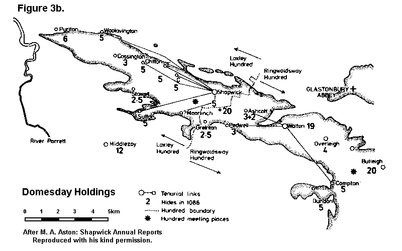
The elucidation of ecclesiastical arrangements within Glastonbury's Polden lands presents something of a problem. It has not yet been possible to identify any church whose known or recorded attributes would allow us to categorize it unequivocally as a minster, and it is perfectly possible that in the early medieval period, the church at Glastonbury itself functioned as the pastoral centre for the entire estate7. A similar relationship, for example, has been shown by Bond to have existed between Evesham Abbey and some of the churches on its dependent lands [Bond 1973]. Having said this, for a variety of reasons, the Old Church of St Andrew at Shapwick has attracted particular attention as betraying indications of potentially very early (seventh to eighth century) capitular status [Costen 1989, 79; and 1992, 118-119]8. One major clue, for example, is that although no church is mentioned at Shapwick in 1086, it nonetheless stood at the head of a large estate of 30 hides with no fewer than five dependent, subsidiary manors on western Polden attached to it (Figure 3) [Costen 1994; Aston and Costen 1994, Fig 11.1, 75].


This is, however, where we begin to encounter some difficulty, particularly if we measure Shapwick against the specifically topographical attributes for minster status sketched out by Blair initially in 1988, greatly expanded and developed in 1992, and further extended and refined in a series of papers since that date [Blair 1988a, 1995, 1996, 1996a, 1996b, 1998]9. Certain of the features that would be considered significant in the Blair model of minster siting are missing at Shapwick, and two in particular stand out: there is nothing topographically distinctive about the site of the Old Church, such as a location on a promontory surrounded on three sides by water; and no river passes through Shapwick, as a corollary of which the place-name itself is a rather 'ordinary' habitative one and not a simplex pre-English river name.
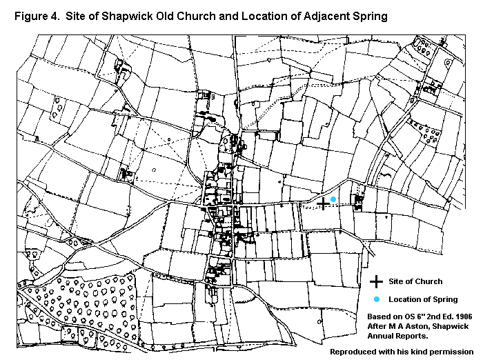
However, although the site of Shapwick Old Church is topographically unprepossessing, we might also consider that if a particular location were deemed important enough for other reasons, it would be perfectly possible for purely topographical considerations to be overidden. We have already noted references to suggest that Shapwick's claim to early importance has some merit, and is implied in a variety of strands of historical and archaeological evidence. Of the latter the most important is the fact that it occupies the site of a substantial and clearly important Roman complex which may be associated with a nearby spring and therefore have ritual connotations, perhaps as a rural shrine (Figure 4) [Gerrard 1995, esp at 108; Aston and Gerrard 1999, 15-23]. Since direct association with Roman structures is another of John Blair's criteria for the identification of primary churches [Blair 1992, 235-246], for whatever reasons this may have happened [Bell 1998; Eaton 2000 and 2001], the balance of probabilities does therefore appear to favour those who support Shapwick's likely status as a capital church at the centre of a large estate.
There is here, however, an intriguing anomaly, for by the post-Conquest period, Shapwick itself was not the mother-church of the estate: it had only a single chapelry, at Ashcott immediately to the east, with Ashcott itself, in turn, the mother church of a chapel in the hamlet of Pedwell [Thomson 1994, 11-12]. Instead, it is Moorlinch which emerges into the light of post-Conquest documentation acting as mother to at least five of the churches lying within the Greater Shapwick estate (Figure 3). These were Sutton Mallet, Chilton, Catcott, Stawell and Edington [Torr 1974-79, 86]. The simplest explanation is that it was indeed Moorlinch, and not Shapwick, which had always been the capitular church of this area, to which the pre-English name Pouelt10 is given in the eighth century Glastonbury charters [Abrams 1996, 204-211]. This model is based on the premise that Moorlinch had probably been founded first and took precedence, with Shapwick as a secondary, dependent church perhaps established with the specific object of christianising a Roman (and perhaps earlier) site.
We cannot, though, be sure whether or not Moorlinch's apparent ecclesiastical superiority in the post Conquest period represents the original arrangement (tenth century or earlier). Of the five dependent chapelries, all were tenurial dependencies of Shapwick in 1086 except Stawell [Abrams 1996, 209], and one inference might be that, for a time at least, ecclesiastical and tenurial development had marched hand in hand, with Shapwick as the mother church, until some point at which Moorlinch was elevated to this status and in the process 'inherited' Shapwick's dependent churches. Moorlinch itself is not mentioned is 1086 and its assessment is almost certainly included with that of Shapwick [Costen 1994, 76-78; Abrams 1996, 179]; and it is interesting that as late as the second quarter of the thirteenth century, it was the Abbot's curia at Shapwick at which his Moorlinch tenants were required to discharge their service obligations [Hobhouse 1891, 155-156]. In the early fourteenth century, the Nomina Villarum recorded 'Shapewyk, cum suis hamel', one of which was Moorlinch [Dickinson 1889, 53], and indeed even two centuries later, Moorlinch was still being described in these terms [Corcos 1982, 28].
Moorlinch might then appear to defy both the clear evidence for its de facto, secular, administrative subservience, and also the logic of what we might reasonably have expected to find, namely Shapwick acting as the ecclesiastical hub of its area throughout its history. It may, though, be possible to explain this difficulty in the form of a radical model of ecclesiastical development which attempts to reconcile the apparently conflicting strands of evidence relating to the two churches, and turning on a consideration of the exact nature of their relationship.
2 Topography and Church Grouping
In complete contrast to the topographically
uninspiring situation at Shapwick, the site of the church of St Mary the
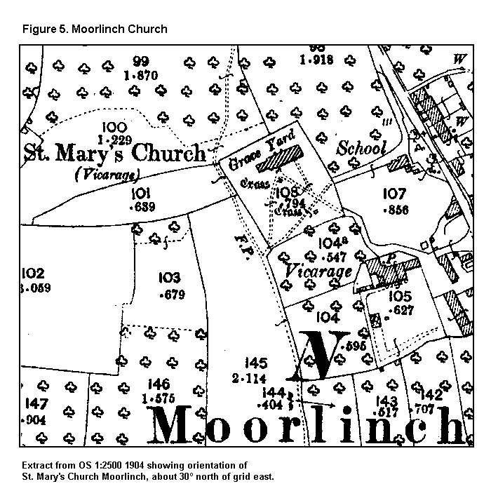
Virgin at Moorlinch is spectacular (Figure 5).
It sits perched on the eastern end of a narrow but steeply-sided ridge
which juts out like a promontory outlier from the main mass of the southern
flank of Polden11. It is to all and
intents and purposes a peninsula, approachable only from the east, and
surrounded on the remaining three sides by sharp slopes to the dry, open
coombes below. The northern side of the ridge is cut by a series of broad
terraces which are clearly artificial, and which curve around its western
end (Plates 1 and 2). The very
striking nature of these features is especially apparent on aerial photographs
[for example: RAF, CPE/UK 1924, 16/1/47, frame 4056].

St Mary's Church Moorlinch, sitting at the eastern end of its promentary and showing the striking series of terraces cut into the northern slope. Looking roughly south-east.
With the sole exception of Stawell, Moorlinch is the only parish centre in western Polden whose place-name appears to be purely topographical in nature, and therefore probably to be included in the earliest stratum of English toponyms [Gelling and Cole 2000, xii-xxiv; Gelling 1998]; although contra Gelling and Cole [2000, 180-182], I would suggest that the hlinc element here is likely to be a reference to the terracing, a corollary of which would be that it was in existence before the toponym was coined. The most obvious, and initially convincing explanation of these terraces is that they are medieval (ie post-Conquest) cultivation lynchets; and certainly this may at least in part explain why they are absent from the southern flank of the 'promontory', since the slope on that side is rather less steep. However, such features are notoriously difficult to date [Astill 1988, 79-80] except on crude morphological grounds or in relation to associated earthworks; and while they may indeed arise from cultivation on a slope, they need not necessarily be post-Conquest in date. The question of the date of the Moorlinch terraces is a matter to which I will return. For now though, I can make two further points: firstly, that Margaret Gelling herself observes that hlinc 'is fairly frequent in charter-boundaries, where it can often be shown to refer to the cultivation terraces on hillsides which are known to modern students of landscape as strip lynchets' [Gelling and Cole 2000, 180]; so clearly, cultivation terracing was not a post-Conquest development, and there seems no reason why the Moorlinch examples should not have been in existence early enough to have inspired the second element of the place-name. Indeed, Dr Gelling's explanation of hlinc in this specific context has found its way onto the back cover of the latest edition of her book on topographical place-names, in the form of a photograph of a contour-track in Moorlinch [Gelling and Cole, 2000], reinforced by a sketch drawing of the same view within the text [ibid: fig 34, 181]. She also appears to leave the way open for the alternative interpretation offered here, in her remark that 'man-made terraces can sometimes be seen at farms with names derived from hlinc' [ibid;182]. However, the implication seems to be that she is talking about contour routeways cut into hillslopes, rather than, as at Moorlinch, a series of clearly-bounded terraces whose function is palpably not communications. In any event, I will return to these features later on, when I hope that their significance for the specifically phenomenological element of my thesis will become clearer.

Looking down on St Mary's church, Moorlinch, from the top of Knoll Hill, to show the wider landscape context. View roughly south west, out across Sedgemoor. The striking set of terraces west of the church should again be very apparent.
Moorlinch church looks uninterruptedly south across Sedgemoor, and west, along the southern flank of the hill12. However, significantly, St Mary's cannot look eastwards, its prospect being comprehensively blocked by the rather higher, broken terrain in that direction. The parish boundary with Greinton, which also forms the boundary between the pre-Conquest hundreds of Loxley and Rigoldsway in this area, runs north / south a km or so to the east of the church (Figure 3).
It seems very clear that the site of Moorlinch church was carefully and quite deliberately chosen, for there is no good reason why it should not instead have been built in a lower and probably more convenient location at the foot of the southern slope, where the village of Moorlinch itself for the most part lies13. It is obvious that the position of St Mary's is designed to impress, and to make a statement about status that would have been clearly understood by contemporaries. Moorlinch church seems strongly to reinforce Altenberg's recent observation, arising from her work on the late medieval landscape of Dartmoor viewed very much from a phenomenological perspective, that
the religious elements in the landscape were dependant on and appealed to the visual sense. A direct visual impact was needed in the landscape if Christianity was to be perceived as superior to nature and therefore convincing and comforting [Altenberg 1999, 28].
In seeking both context and precedent, one does not need to look very far, for leaving aside only the lack of a girdle of water around its 'peninsula', the topographical affinities displayed by Moorlinch church are exactly those so closely associated by John Blair with mother churches of early foundation [Blair 1992; 1996a].
The apparent absence of both a high-status (ie royal) secular site close by and obviously pre-English place-names, and the fact that neither place gave its name to the pre-Conquest hundred in which they both lay (Loxley), might all be seen as compromising Shapwick and Moorlinch's claims to superiority. Even these points have answers, for we have already seen that before passing to Glastonbury Abbey the Polden lands were part of the royal fisc; likewise the likely relative primacy of the toponym Moorlinch. There can be little doubt that those significant affinities associated with Shapwick Old Church that we can identify do appear to be characteristically early. One recent view is that before 1066, it had probably been endowed with a large estate which, described in suspiciously archaic terms, emerges in the post-Conquest period as effectively a sub-manor appropriated by Glastonbury Abbey for the use of its almoner [Costen 1989; and pers comm].
Nonetheless, it does seem questionable whether, considered on its own, Shapwick's case as an important, ancient mother church would necessarily be any stronger than any one of its immediate neighbours. However, between them, it is possible to see that it and Moorlinch, St Mary, satisfy most of the criteria of primary status that modern scholarship would regard as important; and it is this realisation about the significance of their combined attributes which, if applied to an individual church would place its primary status beyond reasonable doubt, that allows us to approach the problem of their relationship from a perspective which is in fact no more than an extension and development of current orthodoxy.
We have seen already that throughout their respective recorded histories, the ties between Shapwick and Moorlinch were intimate. However, what distinguishes them when they emerge in the post-Conquest period, the first time that we can really discern their relationship with any clarity, is a palpable demarcation of function, that was at the same time complementary and mutually dependent. By this time, Shapwick had assumed an overwhelmingly secular mantle at the centre of the old estate's developing 'manorial' and economic administration, so clearly attested in 1086 [Costen 1994], while Moorlinch acted as the ecclesiastical hub. And herein lies the key to understanding the fundamental basis of this duality, for the problem up to now is that, no matter how close their ties, the quite understandable tendency has been to see Shapwick and Moorlinch as separate entities. I would suggest instead that they represent merely two sides of the same coin: they were, on one level, both minsters, indeed, they were one and the same minster. They should be treated as effectively one unit, and one church, albeit on different sites. The respective dedications may provide a crucial clue here, and Dr Blair considers them,
quite suggestive. It is absolutely standard practice for the two main churches of a minster group to be dedicated to an apostle and to the Virgin; Wells itself is an 'Andrew + Mary' group......[we] might like to think of Shapwick and Moorlinch forming a liturgical pair14.
By this view, we can regard Moorlinch as Shapwick's alter ego, a physical extension of itself and a kind of sub- or proxy-minster through which it exercised its primary ecclesiastical prerogatives over its dependent chapels, having been founded for that specific purpose. John Blair's own discussions relating to groups of churches on minster sites, to which I have already referred, provides a basis for this idea, the only major difference here being one of degree in terms of the physical distance between the associated churches [Blair 1992; 1998]. And while he acknowledges that 'the distance between Shapwick and Moorlinch is a bit much', Dr Blair also allows that he is 'very receptive to the idea of a single minster complex comprising churches some way apart' [pers comm Dr John Blair]. This idea may also confirm what we might already suspect regarding contemporary attitudes towards the topographical context of primary churches, and the perceived appropriateness or otherwise of different kinds of site.
Although dating is highly problematic, it may be possible to propose a model for an approximate relative sequence of events. At some time in the second half of the seventh century, a royal church, perhaps taking its dedication from the already important mother church at Wells [Rodwell 1996], was founded at Shapwick Old Church, drawn there by the presence of a substantial, high-status Roman complex, the ruins of which may still at that time have been standing to a considerable height. It is possible that the spring nearby also figured largely in the perceptions of those making the choice, who may have associated the juxtaposition of Roman structures and spring with notions of 'ritual' significance stretching back into antiquity, and perhaps even attested by the remnants of a prehistoric barrow cemetery [Aston 1993, 12-13; Aston and Gerrard 1999, 23-25; Blair 1998; Field 1999; Bell 1998, 4-8 and 9-11]. However, while examples of churches lying on or close to known Roman sites abound, John Blair countenances extreme caution against automatic assumptions of direct, unbroken functional continuity between the two; the idea, he remarks, 'should not be made into an obsession, blinding archaeologists to alternative explanations which may be more convincing'15. He does nonetheless wonder,
how many minsters in western England may have a British past? Certain types of minor cult foci, notably cemeteries and holy wells, could have been maintained within a broad continuum between Romano-Celtic paganism, sub-Roman Christianity, and Anglo-Saxon religious activity both pagan and Christian [Blair 1996b, 6].
Even if a ritual role for Shapwick Old Church in the Roman period is assumed, the case for its functional continuity into Christian usage cannot (yet) be said to stand muster against Blair's unassailable caveats. However, perhaps there are hints here of one possible context against which the idea of appropriation of the site by sub- and post-Roman British Christianity can be modelled? In the time of King Ine of Wessex (688-726), the Irish saint Indract, returning with his nine companions to his homeland after a pilgrimage to Glastonbury, was set upon and murdered by bandits. Reviewing the available literature, Michael Costen has placed the location of Indract's martyrdom in a western marshland detachment of Shapwick parish close to the port of Combwich, at the mouth of the Parrett. The appropriation of Indract's remains provided Glastonbury Abbey with one of its principal foundations in the post-Conquest period for its claims to pre-English antiquity by virtue of its connections to Ireland. Costen notes that the saint is apparently made by his biographer to travel through,
an estate which belonged to Glastonbury and [along] a well-known major route..........directly from the monastery to a place where they might reasonably have taken ship [Costen 1991, 55, and refs there cited].
Indract's milieu is the late seventh / early eighth century, and although he is attested in independent Irish sources [Farmer 1992, 244], his cult was peculiarly localised: he is known to have been venerated only at Glastonbury itself [Lapidge 1982]. Is it possible that, in his Christian incarnation, he actually represents a continuing tradition of pilgrimage, focussed originally in the Roman period on a pagan water-cult shrine associated with the Old Church spring, subsequently adapted to the conditions of a sub-/post-Roman British Christian context, and finally appropriated by Glastonbury Abbey who moved the cult site eastwards to make the object of the pilgrims' veneration Glastonbury itself? Indeed, does Indract represent the personification of the pre-Christian deity who may have been venerated at Shapwick? The work of Miranda Aldhouse-Green in Burgundy has shown how such places could and did become centres of religious pilgrimage in the Roman period, with a pagan god (or, in the case of her site at Fontes Sequanæ, goddess!) later on being metamorphosed into a male saint and deliberately and systematically appropriated into the Christian canon, apparently without any significant break in the ritual tradition [Aldhouse-Green 2000]. Recent work in the area immediately around Walsingham suggests very strongly that the celebrated medieval shrine there may represent an insular example of a similar process, if not of actual functional continuity from the Roman pagan period, then at least of the tenacity of a specifically ritual/religious tradition [Smith 1999].
Interestingly, Aldhouse-Green also describes how Fontes Sequanae was merely one of a number of Burgundian rural shrines a day or so's walk apart, with pilgrims following prescribed routes between them. Although much closer together, this still might provide a further context, in the form of lesser or subsidiary shrines, for the so-called holy wells to be found in or near the villages strung out east/west along Polden's northern flank, forming a route the end destination of which was the putative 'capitular' shrine at Shapwick16. Rather than the main, Roman road along the top of the ridge, now the A39, it may be this more minor, but ritually far more significant routeway that was travelled both by Indract and his companions, and his Romano-British predecessors. Two such locations have survived to be marked on the modern 1:25000 scale map, on the boundary between Cossington and Chilton, and in the centre of the village of Edington [Scherr 1986, especially at 82-85]. The latter is very closely associated with a high-status Roman building dating to the late third or early fourth century [Hollinrake C and N 1994]. Andrew Reynolds has also suggested that springs, wells, ponds and other water sources associated with important churches and/or royal centres may have been involved in the procedure of judicial ordeal [Reynolds 1999, 102].
A similar relationship between the late Roman and early Anglo-Saxon activity at West Heslerton (North Yorkshire), has recently been proposed by Powlesland [1999, 55-56], who considers the survival of a probable shrine or temple complex as having a formative influence on the earliest phase of Anglian activity on the same site. His general conclusions for West Heslerton present an intriguing basis for comparison with Shapwick Old Church [Powlesland 1998, 6.3 - 6.4]. At Shapwick, the obvious connotations of status attached to the Roman building, would also have reinforced the site's claim as a suitable location to be re-used for a primary royal church. Even more significant though would be a continuing local tradition of a religious and ritual focus here, whether or not any actual activities related to that function had continued from the late Roman period. It is possibly this distinction which marked out the Old Church site as suitable for conversion to Christian use. The spring could have been adapted if necessary to provide a ready-made baptistery, and possible parallels with the former temple of Mercury at Uley suggest themselves [Woodward 1992, 100-105]. It is likely that, initially, Shapwick Old Church itself dominated the then royal estate of Pouelt, of whatever extent that may have been.
Having, then, established the background
to Shapwick's minster bona fides, we can now turn to the question of the
possible nature of its relationship with its southern neighbour at Moorlinch.
Shapwick and Moorlinch: A Phenomenological Model
I should stress again that what follows is a purely hypothetical reconstruction of events, inferred from disparate strands of recovered fact, and is merely one possible model that attempts to reconcile such evidence as we have into a coherent narrative of development. We can have no idea of the nature of the church building which Glastonbury Abbey, presumably, inherited from its royal benefactors. We can, though, suggest that the Abbey would have been keen to assert its authority over what was to become one of its most important and productive 'core' estates; one means of achieving this would be through the endowment of churches and, particularly, through the promotion of a suitably prestigious mother church for at least part of the estate. While Shapwick (or rather, its predecessor) seems to have been allowed to remain the administrative centre of the estate, the Old Church, with its (inherited?) dedication to St Andrew, was found wanting. Its low-lying, unprepossessing site did not conform to the Abbey's requirement for a highly-visible church in a dominant position which made a clear public statement about the ancient dignity and authority of its patron. Shapwick Old Church was simply no longer regarded as suitable material for this purpose, and this may be an indication that perceptions of what attributes such a church ought to have were changing, and beginning to crystallise out into something approaching the model of topographical development that has been outlined by John Blair [1992; 1996]. The Abbey, therefore, cast about for a suitable location close by for a church that could, in effect, 'deputise' for Shapwick while at the same time providing both a liturgical partner for it, and the appropriately impressive manifestation of its pastoral obligations that Shapwick could not.
In these circumstances, the choice of the site at Moorlinch was almost inevitable, and may have been made all the more attractive if the massive lynchets which probably gave the place its name were already in existence. A Romano-British or prehistoric origin for these features is by no means impossible, and if so, then even in the eighth century, they would have lent the site an air of 'utter antiquity'. Most important for the phenomenological element of the arguments adduced here, is the fact that the position of the terraces on the north and north-western side of the church peninsula means that they are most immediately striking to a traveller approaching from the north, going south; in other words, coming over the ridge top from the direction of Shapwick and descending the southern slope towards Sedgemoor. This may not be coincidental, and perhaps, then, an explanation that goes beyond the purely functional may be needed to account for these features?
In looking closely at this location, and especially at the terraces, it is difficult to avoid the speculation that a major part of its attraction, whether consciously or otherwise, lay in its remarkable resemblance to Glastonbury Tor, whose own system of terraces may date from the Neolithic [Rahtz 1993, 51-54]; and the form of the Moorlinch promontory as a miniature version of the Tor is indeed striking (Plates 1 and2). Considered in this light, there could hardly be a more appropriate location for Shapwick's new confederate in this ecclesiastical partnership.

Shapwick's physical link to Moorlinch arouses particular curiosity, and may be central to understanding this relationship (Figure 6). Eastwards towards Shapwick its course is aligned directly on the site of the Old Church. Westwards, it becomes Wood Lane, an old route probably related to access into Loxley Wood [Knight 1998, 51], before crossing straight over the main Roman road (now the A39 between Bridgwater and Glastonbury) into a substantial but now very overgrown green lane which still in places shows remnants of cobble metalling (Plate 3). It is certainly this route which was depicted as a still-usable road even by the late eighteenth century [Dunning and Harley 1981]. The antiquity of the entire route at present is problematic, since there is a middle section whose relationship with adjacent field boundaries might suggest a relatively late date17. What is important here though is its subsequent course, for the lane eventually skirts the flank of Knoll Hill via a deeply cut hollow way and descends into Moorlinch by a track that passes through the present churchyard, but which then continues southwards down the southern slope, its line again marked by a prominent but now very overgrown sunken trackway. The churchyard has been extended westwards, and originally the route would have passed immediately to its west.
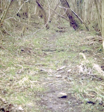 |
The cobbled surface of the lane immediatly south of Loxley Wood and the main Polden ridge road (the A39), forming an extension of Wood Lane and representing one of the north / south routes between Shapwick and Moorlinch. |
Although disrupted by house plots in the lower part of Moorlinch, its general course is continued by paths and tracks which fan out south of the settlement towards Sedgemoor. Although yet remaining to be proven, it is a possibility that this track may represent a direct link between the two churches. This is reinforced by the strong impression that this northern approach to Moorlinch church seems calculated to place the traveller moving towards it in a closely-defined spatial relationship with it, and in doing so allowing them a particularly striking appreciation of the church in its topographical setting18. This is especially so, as we have already noted, in relation to the terraces cut into the northern and north-western flank of the peninsula. An approach from the eastern side, as today, would have been easier and more convenient. It is of course possible, as I have already intimated, that a pre-existing set of Roman or prehistoric terraces were simply re-cut and enlarged after Glastonbury Abbey acquired the site19. However, it is equally plausible that they were constructed de novo specifically to enhance the promontory's already very Tor-like physical characteristics.
A parallel from an earlier period might offer a useful perspective on these features. At Caburn Hill in East Sussex, a Middle Iron Age bank and ditch was constructed around what seems to have been a pre-existing focus of ritual activity dating from at least the Bronze Age, and regarded as somehow a 'sacred' point in the landscape perhaps as early as the Mesolithic. Caburn is usually interpreted as a hillfort, but Drewett and Hamilton argue that the earthworks, far from being defensive, were actually designed to make,
the interior of the enclosure.......highly visible to someone looking up at the hill from a distance away - the ramparts are down-slope and have the effect of emphasising and, as it were, 'monumentalising' ritual activity up above [Drewett and Hamilton 2001, 261].
It could be suggested that the Moorlinch terraces, whatever their date and ultimate origin, and indeed the entirety of St Mary's topographical context, perform essentially the same 'monumentalising' function in a Christian context, representing in their startling resemblance to Glastonbury Tor a quite deliberate attempt to manipulate the psychological perspective of the viewer, and to provoke a very specific emotional and cognitive response20.
Moorlinch may provide us with a way of seeing churches as no longer discrete, isolated sites, but as 'pre-historic' ritual monuments, rooted in a wide and highly dynamic landscape. In much the same sense as any henge, stone circle or long-barrow, they were woven inextricably into a spatial continuum the significance of which was constructed by but at the same time itself also manipulating the cognitive perspective of the viewer. I suggest that in this latter respect there was a significant element of systematic and deliberate intent on the part of those responsible for the siting of churches. The topographical contexts of church sites would perhaps benefit from a reassessment with these imperatives in mind, particularly as regards questions such as intervisibility with neighbours, the layout of communication routes, the visual impact of sites as experienced from various vantage points, looking both inward towards and outwards from the church itself, relationships to significant natural features, estate ownership, territorial antecedents, indicative archaeology, place-names, and so on.
At least part of our aim should perhaps be to develop, test and apply theoretical models of landscape cognition appropriate to the early medieval period, based partly on, but not slavishly following, those currently being applied and now critically re-evaluated by prehistorians. In practice, this would certainly involve an extensive assessment of a large sample of church sites. The application of Geographical Information Systems (GIS) to such data could help enhance our understandings of the territorial role of early churches, aid in assessing how much of the early pastoral pattern was inherited from the past, and assist in exploring the dynamics of 'estate' structure before 106621.
To the prehistorian versed in the theoretical literature, whatever their view on landscape phenomenology, this will not be rocket science. Likewise in the historic period the foundations of this path were brilliantly and firmly laid by both Richard Morris [1989] and John Blair [1988] over ten years ago. I maintain however, that as medievalists, we dismiss landscape phenomenology at our peril. Phenomenological approaches to contemporary perceptions of landscapes are now, as we have seen, being developed by scholars of both earlier and later periods. Without a general recognition of the potential importance of these ideas, there is a danger of early medieval scholarship being somewhat 'left behind', as phenomenological perspectives on landscape history become in their second incarnation a far more incisive analytical tool for all period specialists than perhaps they were in their first.
Footnotes
1 I am greatly indebted to Professor Ronald Hutton, of the Dept of History at the University of Bristol, for reading and commenting on this paper in draft.
2 I am grateful to the anonymous peer reviewers of Assemblage for drawing this latter source to my attention, and for their general comments and guidance.
3 I am grateful to Dave Mullin for the references from Lynch and Hodder.
4 I am very grateful to Dr Jodie Lewis for giving me sight of her own Bristol PhD text (Dept of Archaeology) in advance of its forthcoming publication by BAR. These very same sentiments have been echoed strongly in print recently by Richard Muir, who argues forcefully that while we might usefully seek to develop a coherent body of theory for historic landscape studies, it can be effective only if grounded firmly in the kind of rigorous, systematic and empirical data collection so passionately espoused by Lewis: 'in scores of current projects, theory is used to illuminate the particular, and if landscape history begins to prioritise theory rather than localities and sites it may be surrendering the basis of its individuality' [Muir 2000, 20].
5 Indeed, there is now an annual conference devoted entirely to matters of gender as applied to archaeology. See for example Arnold and Wicker 1999.
6 I mean by this a 'minster' church of probable early foundation, which sat at the head of a large parochia, or territory dependent on it for the purposes of pastoral care. My use of the term here is quite deliberate, and is intended to be recognised as merely the adjectival form of the noun caput, since many minsters were associated with the central or head places of royal estates [Blair 1992, 231; and cf Hase 1994, 52-54 for Wessex].
7 This is a highly contentious area with problems of definition to the fore. However, most workers in this field would probably now accept Blair's argument that there is a range of criteria which can be admitted as evidence in the work of identifying important churches which are likely to be of early foundation. Among these are large parish, dependent churches, early association with royal estate, indicative archaeology, large glebe, attached estate in 1086, place-name, topography, communications nodal point, and closeness to navigable water. To these Blair would add 'pre-Viking charter references, certain kinds of sculpture......complex planning, local saints, residual staffs of clergy'. Blair himself is at pains to stress the fundamental point that 'minsters are identified not on individual criteria, but on recurrent combinations' [my emphasis; Blair 1995, 199-200]. See also Franklin 1984.
8 The present church of St Mary at Shapwick, in the centre of the village, is not the original one. Shapwick Old Church lay in the great East Field, a few hundred metres east of the village, until replaced by the new structure in the early fourteenth century. The move is fully documented in the published registers of Ralph of Shrewsbury, Bishop of Bath and Wells, and all references in the present paper are to the original site; Costen 1991, 48-50.
9 This perspective is complemented by the more textually-based, 'historical' approach to the problem of the identification of pre-Conquest minster churches which is adopted in Blair 1985. The question of how large, early minster parochiæ progressively succumbed to the territorial depredations of the rapidly increasing body of smaller, local churches before 1066, is tackled in Blair 1987 and 1988a.
10Although it should be said that we do not yet know exactly how, in spatial terms, this name was applied, whether it ever became associated with a particular place, or remained merely a district name [Abrams 1996, 210, n117; Aston 1998].
11 I am grateful to Penny Stokes both for her guidance relating to the architectural history of Moorlinch church, and on the nature and function of medieval hill-slope cultivation.
12 Sir Stephen Glynne, in the mid nineteenth century, was moved explicitly to observe that St Mary's occupied a site that was 'elevated and striking, commanding an extensive view' [McGarvie 1994, 242].
13 We might add that a lower, roomier site would have allowed a far more liturgically correct orientation. Bearing in mind the post-Conquest propensity for correcting such defects [Morris 1989, 208-209], it may be significant that the Norman re-build of which there are clear indications in the fabric of the church itself, left the building on its original site, and presumably alignment, offset some 30° north of grid east as measured from the second edition OS 1:2500 survey (1904). Hoare and Sweet have recently shown that while in some cases the Anglo-Saxon approach to orientation appears somewhat cavalier, nonetheless in general 'the early medieval ideal was to obtain a liturgically-correct alignment' [Hoare and Sweet 2000, 169]. They also suggest that anything in excess of an error of ± 10° should be attributed to reasons other than merely 'an inaccurate knowledge of the time of day and a variety of indeterminate causes' [167]. At Moorlinch the particularly idiosyncratic degree of misalignment (Figure 5) was clearly a constraint imposed by the very restricted nature of the site, and may imply that in this case, more important considerations relating to its use over-rode the requirement for strict liturgical accuracy.
14 pers comm Dr John Blair, to whom I am very grateful for his guidance in this respect. The dedication of Shapwick Old Church to Andrew is perhaps best attested in a document which Watkin [1952, cxxxii and 376] dates to the mid thirteenth century. This is a grant, explicitly naming Andrew as patron, of an area 'of reed-bed for a light......in the church there' [ibid, cxxxii]. This record is doubly interesting since not only is the grant given 'in puram et perpetuam elemosinam Deo et Beate Marie et ecclesie Beati Andree de Schapwyk' ', but it also requires that the light is to burn 'coram altare Beate Virginis quod est in eadem ecclesia' [376]. It is possible that this is a reference not to the high altar itself, but to a separate, Marian altar [pers comm Helen Gittos], although whether contained in a projecting side chapel is problematic. The archaeological evidence does not at present suggest it [Gerrard 1995, 108-109; Turner 1998, 42 and 50]. In any event, this seems almost to presage the later change of dedication when the new church at Shapwick was built in the early fourteenth century, and Andrew was abandoned in favour of the Virgin. The twin dedications of the Old Church, therefore, reinforce the intimate and early relationship that seems to have existed between these two figures. Is it possible that Moorlinch owes its dedication to the deliberate transference of the patron of the altar at Shapwick Old Church, so emphasising the insoluble bond between the two churches? A blocked-up, round-headed arch is visible in the external south nave wall of Moorlinch church, with remnants of projecting footings. However, there is no such indicative architecture in the opposing, north wall of the nave, and contra Sir Stephen Glynne, it is likely that this is a simple relieving arch rather than marking the site of a transeptal chapel [McGarvie 1994, 242]. Ex inf Brian and Moira Gittos via Helen Gittos. For a note of caution against the assumption that certain architectural forms (but particularly cruciform types) are invariably indicative of minster status, see Franklin 1984, 74.
15 I am grateful to Professor Ronald Hutton for his advice on this point.
16 One of these north Polden 'Holy Wells' is located at Shapwick itself, but this is not the spring near the site of the Old Church. Rather, it lies a few hundred metres away to the north-east. However, the provenance of the name in this case is highly dubious, and is most likely to be a late fabrication associated with late eighteenth / early nineteenth century emparking. Aston and Costen 1990.
17 The earliest available large-scale map of Moorlinch, dated 1797 and depicting only scattered plots for the purposes of a parliamentary enclosure, appears to confirm the existence of the problematic 'connecting' stretch of lane at least by that date. SRO Q/RDe 169, Moorlinch Enclosure.
18 The nature of this link may be associated at least in part with a use as a formal processional route, as an element of the suggested liturgical relationship between the two churches. I am grateful to Helen Gittos for drawing my attention to this possibility. We can draw direct parallels here with Howard Williams's recent study of the topographical context of the (probably seventh century) Anglo-Saxon burial mound on Lowbury Hill, on the Oxfordshire/Berkshire boundary: 'the main axes of movement through the landscape would have been important for the builders of the Lowbury barrow, since they structured the ways in which the barrow would be seen, experienced and interpreted. Perhaps such routes were incorporated into the funeral procession in some way' [Williams 1999, 75].
19 If this was the case, then another dimension to the adoption of the promontory for church building may have been a concern to 'Christianise' or 'de-paganise' a site whose unusual physical characteristics may have been explicable to those making the choice only in terms of possibly magical pre-Christian religious practices, associations which they would have regarded as dangerous and undesirable; Holtorf 1997; Semple 1998, 120-121. Indeed, elsewhere, in the area of Galicia in north-west Spain, Oubiña et al suggest that entire landscapes of prehistoric monuments, their ritual affinities quite clearly understood, may have been deliberately and systematically appropriated into Christian ideology: 'these would have to be considered as examples of the maintenance throughout time of the sacred characteristics of a particular place.........the Christianisation of archaeological spaces would amount to much more than negating the preceding cultural system.........It is instead an example of the construction of a new social and ideological order based on the appropriation of the past' (authors' emphasis). Oubiña et al 1998, 174.
20 I am grateful to my brother, Dr Christopher Corcos, for his guidance on the strict clinical and psychological aspects of landscape perception. A full phenomenological perspective on early medieval landscapes is surely only a logical development of the already widely-accepted idea that the richness of the Anglo-Saxon toponymic vocabulary springs directly from a profound acuity of topographical awareness. The early medieval traveller was guided by a detailed 'mind map' underpinned by an intricate and highly specific structure of place-names rooted in direct experience and observation of the natural topography. See Cole 1994, and Gelling and Cole 2000, xii-xxiv. So-called Spatial Framework Models developed by cognitive psychologists show that 'certain spatial directions.......are especially prominent in our thinking' [Matlin 1998, 218]. The anthropological implications of this personal 'categorization of space' (Darvill's phrase) have been recognised for some time, but it is only recently that archaeologists have begun to apply the idea in an attempt 'to understand the values that prehistoric people attributed to sectors of their landscape' [Darvill 1997, 76, and citing work by Tuan and Sennett]. Interestingly, it seems that the overwhelmingly dominant dimension in this respect is up/down, or above/below: in other words, the fundamental basis of our perspective in relation to the world is verticality. In the case of Moorlinch church, for example, this powerful and deep-seated affinity finds expression in the fact that the church appears most impressive to the onlooker from either above or below. It would, clearly, be absurd to claim that the site was chosen from direct knowledge of this principle; nonetheless, I would argue that the choice did spring from a conscious appreciation of those inherent topographical qualities of the site which could be harnessed to enhance the visual impact of the church, and of the way in which the perspective of the viewer could be deliberately manipulated to achieve that end.
21Although we should also note that, as Howard Williams has tellingly demonstrated recently, GIS itself is not without its drawbacks, and would be by no means a universal panacea for work of this kind. Williams 1999, especially at 62-63.
Bibliography
Abrams L, 1996. Anglo-Saxon Glastonbury: Church and Endowment. Woodbridge, Boydell.
Aldhouse-Green
M, 2000. On the Road. British Archaeology 52, April 2000.
Altenberg K, 1999. Space and Community
on Medieval Dartmoor and Bodmin Moor: Interim Report. Medieval Settlement
Research Group Annual Report, 14.
Arnold
B, and Wicker N L, (eds) 1999 From the Ground Up: Beyond Gender
Theory in Archaeology - Proceedings of the Fifth Gender and Archaeology
Conference, 1998, BAR International Series 812.
Astill G, 1988. Fields. In, The Countryside
of Medieval England. (eds G. Astill and A. Grant). Oxford, Blackwells.
Aston M A, 1993. Mounds: Barrows, Watermills, Windmills and Limekilns. In, The Shapwick Project: Fourth Report (eds M. A. Aston and M. D. Costen). University of Bristol.
Aston
M A, 1998. The Development of Settlement at Shapwick: Current Ideas (1997).
In, Shapwick: The Eighth Report (eds M. A. Aston, T. A. Hall and
C. M. Gerrard). University of Bristol.
Aston M A, and Costen M D, 1990. A Holy
Well at Northbrook?. In, The Shapwick Project: Third Report (eds
M. A. Aston and M. D. Costen). University of Bristol.
Aston M A, Costen M D (eds), 1994 The Shapwick Project: Fifth Report. University of Bristol
Aston M A, Gerrard C, 1999. 'Unique, Traditional and Charming': The Shapwick Project, Somerset, Antiquaries Journal 79.
Bell T, 1998. Churches on Roman Buildings: Christian Associations and Roman Masonry in Anglo-Saxon England, Medieval Archaeology 42.
Bender B, 1998. Stonehenge: Making Space. Oxford, Berg.
Bender
B, et al, 1997. Leskernick: Stone Worlds; Alternative Narratives; Nested
Landscapes, Proceedings of the Prehistoric Society 63.
Beresford M, 1958. The Lay Subsidies:
Part I - 1290-1334, The Amateur Historian 3.
Beresford M, 1958a. The Poll Taxes of 1377, 1379 and 1381, The Amateur Historian 3.
Beresford M, 1959. The Lay Subsidies: Part II - After 1334, The Amateur Historian 4.
Blair J, 1985. Secular Minster Churches in Domesday Book. In, Domesday Book: A Reassessment (ed P. Sawyer). Edward Arnold, London.
Blair J, 1987. Local Churches in Domesday Book and Before. In, Domesday Studies (ed J. C. Holt). Woodbridge, Boydell.
Blair
J, 1988. Minster churches in the landscape, In, Anglo-Saxon Settlements.
(ed D Hooke), Oxford UP.
Blair J, 1988a. Introduction: from Minster
to Parish Church, In, Minsters and Parish Churches: The Local Church
in Transition 950-1200 (ed J. Blair) OUCA Monograph 17.
Blair J, 1992. Anglo-Saxon Minsters: A Topographical Review. In, Pastoral Care Before the Parish. (eds J. Blair and R. Sharpe) Leicester UP.
Blair J, 1995. Debate: Ecclesiastical organisation and pastoral care in Anglo-Saxon England, Early Medieval Europe 4.
Blair J, 1996. Palaces or Minsters? Northampton and Cheddar Reconsidered, Anglo-Saxon England 25.
Blair J, 1996a. The Minsters of the Thames, In The Cloister and the World (eds J. Blair and B. Golding).Oxford UP.
Blair J, 1996b. Churches in the early English landscape: social and cultural contexts, In, Church Archaeology: Research Directions for the Future (eds J Blair and C Pyrah), CBA Research Report 104.
Blair J, 1998. Bampton: An Anglo-Saxon Minster, Current Archaeology 160, Vol 14, No 4.
Bond C J, 1973. The Estates of Evesham Abbey: A Preliminary Survey of Their Medieval Topography.Vale of Evesham Historical Society Research Paper 4
Bradley R, 1998. The Significance of Monuments: On the Shaping of Experience in Neolithic and Bronze Age Europe. London, Routledge.
Bradley R, 2000. Mental and Material Landscapes in Prehistoric Britain. In, Landscape: The Richest Historical Record (ed D. Hooke),. Westbury, Society for Landscape Studies.
Children G, and Nash G, 1997. Establishing a Discourse: The Language of Landscape. In, Semiotics of Landscape: Archaeology of Mind. (ed G. Nash), BAR International Series 661.
Cole A, 1994. The Anglo-Saxon Traveller, Nomina 17.
Corcos N J, 1982. Shapwick: The Enclosure of a Somerset Parish, 1515-1839 (unpublished MA thesis, Leicester).
Corcos N J, 1983. Early Estates on the Poldens and the Origin of Settlement at Shapwick, SANHS 127.
Corcos N J, 2001. The Affinities and Antecedents of Medieval Settlement:Topographical Perspectives from Three of the Somerset Hundreds, unpublished PhD thesis, Bristol.
Costen M D, 1989. The Origins of the Rectorial Manor of Shapwick, In, The Shapwick Project: Second Report (ed M. A. Aston), University of Bristol.
Costen M D, 1991. Some evidence for new settlements and field systems in late Anglo-Saxon Somerset. In, The Archaeology and History of Glastonbury Abbey (eds L. Abrams and J. Carley). Woodbridge, Boydell.
Costen
M D, 1992. The Origins of Somerset. Manchester UP.
Costen M D, 1994. The Domesday Book for
Shapwick. In, The Shapwick Project: Fifth Report (eds M. A. Aston
and M. D. Costen). University of Bristol.
Darvill T, 1997 Landscapes and the Archaeologist, In, Making English Landscapes: Changing Perspectives (eds K Barker and T Darvill). Oxford, Oxbow.
Davis R H C, 1987. Domesday Book: Continental Parallels, In, Domesday Studies. (ed J. C. Holt). Woodbridge, Boydell.
Dickinson F H (ed), 1889. Kirby's Quest for Somerset, SRS 3.
Drewett P, and Hamilton S, 2001. Caburn: Sacred Mount or Classic Hillfort?, Current Archaeology 174, vol 15 no 6 (June 2001).
Dunning R W, Harley J B, 1981. Somerset Maps, SRS 76.
Eaton T, 2000. Plundering the Past: Roman Stonework in Medieval Britain. Stroud, Tempus.
Eaton T, 2001. Old Ruins, New World. British Archaeology 60 (August 2001).
Faith R, 1997. The English Peasantry and the Growth of Lordship. Leicester UP.
Farmer D H, 1992. The Oxford Dictionary of Saints (fourth edn). Oxford.
Field D, 1999. Bury the Dead in a Sacred Landscape, British Archaeology 43 (April 1999).
Flannery K V, Marcus J,1996. Cognitive Archaeology, In Contemporary Theory in Archaeology (eds R. Preucel and I. Hodder). Oxford, Blackwells.
Fleming A, 1999. Phenomenology and the Megaliths of Wales: A Dreaming Too Far?. Oxford Journal of Archaeology 18.
Fowler P J, 1998. Moving through the Landscape, In, The Archaeology of Landscape: Studies Presented to Christopher Taylor. (eds P. Everson and T. Williamson). Manchester UP.
Fox H S A, 1996. Exploitation of the Landless by Lords and Tenants In, Early Medieval England. In, Medieval Society and the Manor Court. (eds Z. Razi and R. Smith). Oxford UP.
Franklin M J, 1984. The Identification of Minsters in the Midlands. In, Anglo-Norman Studies 7 (ed R. Allen Brown).
Gelling M, 1998. Place-names and Landscape, In, The Uses of Place-Names (ed S Taylor). Edinburgh, Scottish Cultural Press.
Gelling M, Cole A, 2000, The Landscape of Place-Names. Stamford, Shaun Tyas.
Gerrard C M, 1995. Excavations in the Church Field (4016), Shapwick, 1993 Preliminary Report. In, The Shapwick Project: Sixth Report. (eds M. Aston and C. Gerrard). University of Bristol
Gibbens L, 1994. An Introduction to Church Registers. Birmingham, Federation of Family History Societies.
Gilchrist R, 1993. Gender and material culture: the archaeology of religious women. London, Routledge.
Gilchrist R, 1995. Contemplation and Action: The Other Monasticism. Leicester UP.
Gilchrist R et al, 1996. Review Feature: Gender and material culture: the archaeology of religious women, Cambridge Archaeological Journal 6:1.
Gilchrist
R, 1999. Gender and Archaeology: Contesting the Past. London, Routledge.
Glasscock R E (ed), 1975. The Lay Subsidy
of 1334. London, The British Academy.
Hase P H, 1994. The Church in the Wessex Heartlands, In, The Medieval Landscape of Wessex (eds M. A. Aston and C. Lewis). Oxford, Oxbow.
Hey D (ed), 1996. The Oxford Companion to Local and Family History. Oxford
Hoare P G and Sweet C S, 2000. The orientation of early medieval churches in England. Journal of Historical Geography 26.
Hobhouse E (ed), 1891. Rentals and Custumals of Michael Amesbury and Roger Ford, SRS 5.
Hodder I, 2000. British Prehistory: Some Thoughts Looking In, review article, Cambridge Archaeological Journal 10:2.
Hollinrake C and N, 1994. Archaeological Fieldwalking Along the Line of the Polden Villages Pipeline, Woolavington to Shapwick, Polden Villages Enhancement Scheme, unpublished report no 71, Somerset County Council
Holtorf C J, 1997. Christian Landscapes of Pagan Monuments: A Radical Constructivist Perspective. In, Semiotics of Landscape: Archaeology of Mind, (ed G. Nash), BAR International Series 661.
Hooke D, 1998. The Landscape of Anglo-Saxon England. Leicester UP.
Hoyle R, 1994. Tudor Taxation Records: A Guide for Users PRO Readers' Guide 5. HMSO
Johnson M, 1999. Archaeological Theory: An Introduction. Oxford, Blackwells.
Jurkowski M et al, 1998. Lay Taxes in England and Wales 1188-1688 PRO Handbook 31. HMSO.
Knight J, 1998. The Landscape Archaeology of Loxley Wood, Shapwick, Somerset, unpublished MA dissertation, Bristol.
Lapidge M, 1982. The Cult of St Indract at Glastonbury. In, Ireland in Early Medieval Europe (ed D Whitelock). Cambridge UP.
Laurence R, 1999. Theoretical Roman Archaeology (review article), Britannia 30.
Lowe K A, 1998. The Development of the Anglo-Saxon Boundary Clause, Nomina 21.
Lynch F, 1996. Review of Tilley 1994, Landscape History 18.
Mackenzie I M, 1994 Archaeological Theory: Progress or Posture? Aldershot, Avebury.
McGarvie M (ed), 1994. Sir Stephen Glynne's Church Notes for Somerset, SRS 82.
McGlade J, 1995. Archaeology and the Ecodynamics of Human-Modified Landscapes, Antiquity 69.
McGlade J, 1999. Archaeology and the evolution of cultural landscapes: towards an interdisciplinary research agenda, In, The Archaeology and Anthropology of Landscape: Shaping Your Landscape. (eds P. J. Ucko and R. Layton)
Massey R, 1999. The North Oxfordshire Grim's Ditch: Cult, Status and Polity in the Late Pre-Roman Iron Age, unpublished MA dissertation, Bristol.
Matlin M W, 1998. Cognition (fourth edn). Fort Worth, Harcourt Brace College.
Moreland J, 1991. Method and Theory in Medieval Archaeology in the 1990s. Archeologia Medievale 18.
Morris R, 1989. Churches in the Landscape. Dent, London.
Muir R, 2000. Conceptualising Landscape, Landscapes 1.
Oubiña C P, Boado F C, and Estévez M S, 1998. Rewriting landscape: incorporating sacred landscapes into cultural traditions, World Archaeology 30.
Percival J, 1985. The Precursors of Domesday: Roman and Carolingian Land Registers. In, Domesday Book: A Reassessment, (P. Sawyer ed). London, Edward Arnold.
Phythian-Adams C, 2000. Environments and Identities: Landscape as Cultural Projection in the English Provincial Past. In, Environments and Historical Change: The Linacre Lectures 1998. (ed P. Slack). Oxford UP.
Powlesland D (ed), 1998 The West Heslerton Assessment, Internet Archaeology 5. (http://intarch.ac.uk/journal/issue5/index.html).
Powlesland D, 1999. The Anglo-Saxon Settlement at West Heslerton, North Yorkshire, In, Northumbria's Golden Age. (eds J. Hawkes and S. Mills). Stroud, Alan Sutton.
Rahtz P, 1993. Glastonbury. London, Batsford/English Heritage.
Reynolds A, 1999. Later Anglo-Saxon England: Life and Landscape. Stroud, Tempus.
Rodwell W, 1996. Above and Below Ground: Archaeology at Wells Cathedral. In, The Archaeology of Cathedrals, (eds T. Tatton-Brown and J. Munby), OUCA Monograph 42.
Scherr J, 1986. Names of Springs and Wells in Somerset. Nomina 10.
Semple S, 1998. A fear of the past: the place of the prehistoric burial mound in the ideology of middle and later Anglo-Saxon England. World Archaeology 30.
Smith J B, 1999. Votive Objects and Objects of Votive Significance from Great Walsingham. Britannia 30.
Thomson G, 1994. All Saints' Church, Ashcott: Historical and Descriptive Notes (Second edn).
Tilley C, 1994. A Phenomenology of Landscape, London, Berg.
Tilley C, 2001. Review of Richard Bradley, An Archaeology of Natural Places (2000), Cambridge Archaeological Journal 11.
Torr V J, 1974-79. Ecclesiastical Somerset in 1563, SDNQ 30.
Turner A, 1998. Geophysical Survey in Fields 7372, 7951, 7722 and 4016, Undertaken in 1997. In, The Shapwick Project: Eighth Report (eds M. A. Aston, T. A. Hall and C M Gerrard). University of Bristol
Ucko P J, 1995. Theory in Archaeology: A World Perspective. London, Routledge.
Watkin A (ed), 1952. The Great Cartulary of Glastonbury Abbey, II, SRS 63.
Whitley D S, 1998. Reader in Archaeological Theory: Post-Processual and Cognitive Approaches. London, Routledge.
Williams H, 1999. Placing the dead: investigating the location of wealthy barrow burials in seventh century England. In, Grave Matters, (ed M. Rundkvist), BAR International Series 781.
Williamson T, 2000. Understanding Enclosure, Landscapes 1.
Witcher R, 1998. Roman Roads: phenomenological perspectives on roads in the landscape, In, TRAC 97: Proceedings of the Seventh Annual Theoretical Roman Archaeology Conference. (eds C. Forcey, J. Hawthorne and R. Witcher), Oxford, Oxbow.
Woodward A, 1992 Shrines and Sacrifice, London, Batsford/English Heritage.
In September 2000, following a less than distinguished career with BT (after over eleven years of service, the company finally 'paid' him to leave), Nick Corcos left over-salaried corporate insanity behind to complete his PhD in the Department of Archaeology at Bristol University (awarded in May this year), and to try to pursue his first love, early medieval landscape history, as a career. His main interests centre around the origins and nature of rural settlement in the pre- and immediately post-Conquest periods, including early territorial arrangements and the role of the Church in influencing patterns of development in the wider landscape. He is currently working as a Site Assistant for Bristol and Region Archaeological Services, and can be contacted at: [email protected]
| Top |
|
assemblage - the Sheffield graduate journal of archaeology
[email protected]
Research School of Archaeology and Archaeological Sciences
University of Sheffield
2 Mappin Street
Sheffield S1 4DT
Tel: (0114) 222 5102 Fax: (0114) 272 7347
Last Updated: 9.8.01