 Introduction
The availability of water has played a central
role in the settlement patterns of the Near East and North Africa.
Along with food acquisition, which has generally received more attention,
Clark describes water as “...that other necessity of life,
bound up so intimately with the distribution and density of human
settlement” (Clark 1944: 1). This is a commonly accepted view
(Miller, 1980; Trigger 1968: 61), although Wagstaff does not regard
water availability as a major determinant in settlement location
(Wagstaff 1985: 51).
No settlement, however, whether permanent or seasonal, can exist
without some form of access to water. Surface water, in the form
of streams / rivers, lakes, channelled and collected rainwater and
natural springs, was obviously the most readily accessible source
of water, but over time subterranean water resources were also tapped
by wells. As a distinct class of installations, however, wells remain
little studied in general and are often regarded merely as a nuisance
by excavators (Bibby 1970: 159).
The core hypothesis to my on-going research is that wells and well-related
architecture can be considered as indicators of social complexity
and behaviour. By definition, a well is simply “a deep hole
in the ground from which water, oil or gas can be obtained”
(Cambridge International Dictionary of English - online). The majority
of wells, however, are more than simple, isolated holes in the ground
such as those found at Kissonerga-Mylouthkia (Peltenburg et al.
2000: 846) and wells F7010-7013 at Hala Sultan Tekke (Åström
1997: 66), both on Cyprus.
Some wells are found in central, open spaces within a settlement,
such as at Megiddo in Israel (Lamon 1935) and thus it seems reasonable
to classify them as being communal installations, with unrestricted
access. The location of other wells, however, in a variety of enclosed
spaces ranging from domestic buildings (at Garama in Libya and Mohenjo-Daro
in Pakistan, for example) to ritual buildings (at Hacılar in
Turkey) and palaces (at Nimrud in Iraq), suggests that access rights
to their water may have varied considerably. As Kramer notes in
her ethnographic study of a village in Iran:
‘The fact that they [wells and latrines] are differentially
distributed throughout the village suggests the possibility that
they reflect economic variation among households’ (Kramer
1982: 131).
If access rights to well-water did vary as a result of social differentiation,
based on wealth, ideology and / or power, and if this is reflected
in the surrounding architecture, then wells can be considered as
indicators of social complexity. Their potential value as signatures
of social complexity will be greatest where wells can be analysed
through time and space, both at a macro, regional level and at a
micro, intra-site level. In such cases, an excavated sequence of
wells and well-related architecture may provide evidence of social
change through time.
This paper will attempt to outline the techniques employed to tap
subterranean water, the distinction between pits and wells, and
the various well construction types. It will then summarise the
‘time-depth’ or history of wells, and demonstrate how
access to water has often been a contentious issue, before outlining
a classification system for wells and discussing preliminary data
from four sites, which exemplify the main classification types.
It will conclude by suggesting potential avenues for further research,
in the light of the currently available data.
Tapping subterranean water
Water availability depends heavily on the
local geomorphology, as well as hydro-technology. A selection of
accounts from 19th and 20th century travellers, such as Rogers in
Palestine (Rogers 1989 [1862]: 266, 289) and Stark in Iraq (Stark
1947: 92-93), provide us with detailed anecdotes on wells in the
age before the widespread use of diesel pumps. The ‘by-wells’
recorded in Arabia (Doughty 1936 [1888], II: 355) resembled little
more than wide sand pits, excavated to clay level, similar to the
shallow wells dug daily by Stein’s companions in Inner Asia
and the Taklamakan Desert (Stein 1928: 316; Stein 1996 [1912], II:
386) and the ‘sip-wells’ in the Kalahari (van der Post
1958: 216).
In these ethnographic cases, detailed environmental knowledge enabled
indigenous people to locate water in apparently waterless environments,
although as Miller points out, the digging of shallow pits to reach
subterranean water in deserts is a practice not restricted to humans
(Miller 1980, 333).
Elsewhere, the customary mixture of luck, experience and trial and
error doubtless played its part in finding subterranean water. Peltenburg
et al. suggest that the precision required to hit the water channels
at Kissonerga-Mylouthkia is evidence of possibly the earliest known
water divining / dowsing (Peltenburg et al. 2001: 48), whereas Jansen
proposes that the knowledge of subterranean water in the Indus Civilisation
may have originated as a fortuitous by-product from digging deep
pits for potters’ clay (Jansen 1989: 180).
When is a hole in the ground a well?
Sip-wells and by-wells are difficult to find
in the archaeological record and highlight the fact that the recognition
of wells is not always as simple as it might seem. At the prehistoric
site of Beidha in Jordan, Miller notes that there may have been
similar, temporary well pits dug into the wadi floor (Miller 1980,
331), although Kirkbride and Byrd only refer to the present-day,
local springs (Byrd 1989, 17; Kirkbride 1966, 71; 1968, 264).
Both pits and wells can be lined, so accurate information on water-table
fluctuations is required, if self-reinforcing arguments are to be
avoided (for example, the pits / wells at the Chalcolithic site
of Teleilat Ghassul in Jordan – Bourke pers. comm. - and at
Tell Brak in Syria – Oates et al. 2001: 26).
Thus, the functions of holes in the ground cannot be assumed to
be single nor constant – a hole being dug as a well shaft
may collapse and thus be turned into a pit (‘well’ F7011
at Hala Sultan Tekke, for example - Åström 1997); similarly,
a hole intended as a pit may hit water or a well may dry up and
be converted into a latrine (‘well’ F1552 at Hala Sultan
Tekke - Åström 1997: 26) or a rubbish pit. The North-West
Palace wells at Nimrud contained, among other things, large quantities
of broken ivory furniture and writing boards, robbed of their presumed
gold hinges, not to mention over 180 manacled bodies of young males
in Well 4 (Oates and Oates 2001: 99-100) - perhaps the earliest
example of an attempt to cover-up or at least dispose of a war-crime.
‘Constructed’ brick and stone-lined wells obviously
require a greater investment of labour, preserve better and are
consequently more visible in the archaeological record than un-lined
holes in the ground. Putative reasons for the differential location
of such wells relative to the surrounding architecture can, therefore,
be investigated, if the local hydro-geology is relatively uniform.
‘Constructed’ wells
Clark rightly distinguishes between tapping
existing springs and the “revolutionary innovation”
of wells tapping subterranean water, indiscernible from the surface,
while noting the potential difficulties in distinguishing between
the two, especially if the spring is lined (Clark 1944: 6).
Most wells that tap deep water have reinforced sides, if only to
prevent slippage of the well sides in unstable deposits. The Megiddo
‘well’ shaft, dug through 30 m of earlier habitations
and bedrock, to tap water channelled along a 65 m long tunnel from
the spring, required major retaining walls to prevent slumps (Kempinski
1989: 130-131; Lamon 1935: 14). The Kissonerga-Mylouthkia wells,
however, are merely cylindrical shafts, dug a minimum of 7-8 m deep
into the ground and as such emphasize that relatively deep wells
do not necessarily need constructed sides, where the geological
conditions are sufficiently stable.
The sides of ‘constructed’ wells are usually lined by
stone or baked mud-bricks, although several wooden well shafts dating
to the Neolithic and later have been found in Central Europe (Baldia
2000; Clark 1944: 5, 6; Renfrew and Bahn 2000: 264).
The availability of wood and exceptional conditions required to
preserve it doubtless skew its known distribution. This, however,
does not preclude the likelihood that wood was used in well superstructures
in less forested, more arid regions – for example fragments
of wooden beams and several squared stones point to the existence
of a wooden platform over the well shaft at Megiddo (Lamon 1935:
31-32).
Maintenance and extracting water became increasingly difficult as
wells became deeper. Foot / hand-holes cut into well shaft sides
are found at Kissonerga-Mylouthkia (Peltenburg et al. 2000: 846),
Hala Sultan Tekke (Åström 1997: 67), Tell Brak and Garama
(Figure 1). More durable steps have been found
in the stone-lined well (BLDG 500) at Saar, on Bahrain (Farid and
Killick, pers. comm.), and at the well at Masturah in Arabia, for
the benefit of travellers without ropes (Lawrence 1935: 80).
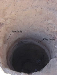
Figure 1: Foot/hand holds in the central well at Garama - note also
the remnants of the lower clay lining
Other, larger wells had rock-cut stairways
- the well at the Kushite (8th Century BC) site of el-Kurru, in
the Sudan (Welsby 1998: 128), the 3rd Millennium BC well at Diraz,
Bahrain (Bibby 1970: 68) and the 12th Century BC well at Megiddo
(Lamon 1935: 14). The most impressive access-route to a well, however,
is the Iron Age stone staircase (Figure 2) at
Tell Es-Sa’idiyyeh in Jordan (Miller 1988). The durability
of these access features suggests a high volume of usage over a
long period. Some of the large wells in open areas were probably
communal wells, although the hut associated with a well in the Southern
Suburb at Tell El-Amarna in Egypt (Kemp 1977: 135) may indicate
some form of supervision, if not toll.
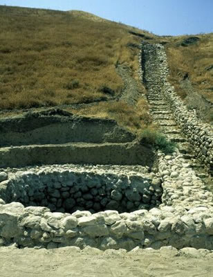
Figure 2: Stone staircase from the top of the mound to the well
at Tell Es-Sa'idiyyeh (photo: C. Thomas)
The digging and construction of wells was
a skilled craft (Stein 1928: 717), reserved for specialist well
sinkers in parts of Arabia (Doughty 1936 [1888], II: 421), the Near
East (Miller 1980: 339) and Iran (Kramer 1982: 70) [Footnote
1]. The inhabitants of Mohenjo-Daro can be regarded as the masters
of well construction - an estimated 700 were sunk within the city
limits, amounting to one well for every third house, on average
(Jansen 1993: 118).
Clark, among others, associates the increased technological input
required for constructed wells with the pressures of increased demand
in urban areas (Clark 1944: 3; 1960: 198), although Peltenburg et al. point out that there is no evidence for such large settlements
in the Cypro EPPNB associated with the Kissonerga-Mylouthkia wells
(Peltenburg et al. 2001: 34) and the inhabitants of many large settlements
were able to supply themselves with sufficient water without resorting
to digging vast numbers of wells.
The number and density of wells at Mohenjo-Daro is not even approached
at any other archaeological site and the sudden florescence of their
integrated water and sewage management system is made all the more
remarkable by the fact that no wells nor drains have yet been found
at either Pre- or Early Harappan sites (Jansen 1989: 179; 1993:
117). The number of wells at Mohenjo-Daro is also in marked contrast
to other Indus Civilisation cities such as Harappa (Vats 1940: 13),
where 8 have been excavated and an estimated 30 existed (Kenoyer
1998: 58); none have been found at the contemporary sites of Dholavira
and Taxila (Marshall 1975: 95).
In his study of the water systems at Mohenjo-Daro, Jansen concludes
that ‘... the only technically feasible manner of construction
would be the “shaft-sinking” method’, which was
still used until recent times (Jansen 1993: 118). This technique,
known as ‘caisson-sinking’ in engineering (Watt and
Wood 1979: 53-54; Thomas, A. pers. comm.), utilises the weight of
the growing brick structure to sink the lining, as underlying earth
is removed at the base.
An alternative method, known as ‘underpinning’, involves
inserting the bricks at the base, as deposits are removed, but this
would require one odd-shaped brick to complete each course, leaving
the lining less stable; none of the wells investigated at Mohenjo-Daro
provide evidence for this technique. The stability of the technique
employed is demonstrated by the fact that shaft depths of over 20
m were reached at Mohenjo-Daro, as they were at Nimrud where the
lining of two of the wells consisted of over 300 courses of bricks
(Oates and Oates 2001: 92, 100).
The ‘time-depth’
of wells and developments in lifting technology
The discovery of wells at Kissonerga-Mylouthkia
dating to the later 10th and 9th Millennium BP, the contemporary
well at Shillourokambos, also in Cyprus (Peltenburg et al. 2000:
848) and the plausible claims for submerged wells at Atlit-Yam,
off the coast of Israel, dating to the late Pre-Pottery Neolithic,
c. 8100-7500 BP (Galili et al. 1993), attest to the long ‘time-depth’
or history of well-digging. Similarly, Miller (1980) provides an
informative survey of wells dating from the Neolithic to the Bronze
Age in Syria and Palestine.
Numerous Assyrian texts (published in the State Archives of Assyria
series), the Epic of Gilgamesh (Gilgamesh and Akka 1-23) and the
Old Testament of the Bible contain references to sites with wells
(Anati 1963: 384; Keller 1958: 395; Herzog 1993: 167-9; Smith 1966:
440). The Akkadian words ‘burtu’ and ‘buru’
mean ‘well’, as does the Arabic word ‘bir’
and the Hebrew word ‘beer’, both of which are often
found in place names – Beersheba, for example (Genesis 21:
22-31; 26: 33).
As rural villages developed into urban centres, complex water management
and supply systems were devised, to satisfy the increased demand
for water. The cities of Ugarit (Caubet 1995: 2672), Ebla (Miller
1980: 337) and Mohenjo-Daro (Piggott 1961: 135, 170) provide good
examples of these systems, although Hughes questions the long-term
ecological and sanitary consequences of reliance on well water in
Greek and Roman cities (Hughes 1975: 83, 121). The platform beside
the well at Tell Es-Sa’idiyyeh may have been built to reduce
the risk of contamination (Miller 1988: 87), as may have the proposed
platform at Megiddo.
The reign of Sennacherib (705-681 BC) saw the first introduction
of the Egyptian ‘well-sweep’ to Assyria (Olmstead 1923:
331). The ‘well-sweep’ or ‘shaduf’ is used
to irrigate land along the Nile and in large wells at Tell El-Amarna
(Kemp 1991: 291). It probably complemented, rather than replaced,
the rope and bucket ‘draw wells’ [Footnote
2], but after this, lifting technology did not advance for about
another 500 years.
From about the 2nd Century BC the Greeks and Romans used the ‘Ktesibian
machine’, a twin-cylinder type of pump, named after its supposed
inventor, a 3rd Century BC Alexandrian Greek (Landes 1988: 343).
Worked at a leisurely pace, the pump could raise around 1000 litres
per hour, a significant improvement on the laborious task of manually
drawing water [Footnote 3]
and / or using teams of animals, which was costly and dangerous
(Doughty 1936, II: 382, 497).
The increasingly mechanised extraction of well-water, particularly
with the introduction of petrol pumps in the 20th Century, can be
seen in the Fezzan, Libya, where animal draws were replaced by motor
driven winches in deeper wells, which were in turn replaced by bore-holes.
This ‘...pursuit of the falling water table by the successive
introduction of different lifting technologies...’ (Mattingly
et al. 1999: 142), in many arid areas, has placed unparalleled demands
on subterranean water resources, as can be seen, for example, in
the rapidly falling water-tables in the Fezzan (Mattingly et al.
2000: 113) and in Bahrain (Larsen 1983: 16).
Water and disputes
‘I suppose that, after the passion
of love, water rights have caused more trouble than anything else
to the human species’ (Stark 1947: 106). Whether wholly accurate
or not, the main causes of the disputes over water are its uneven
distribution in arid regions and the resultant restricted access
to water sources. The potential ‘flash-point’ for disputes
at wells is noted in an archaeo-ethnographic study of a village
in Iran, where Watson comments: ‘Apportioning the water is,
of course, a serious problem (as the summer draws on, it may lead
to bloodshed)’ (Watson 1979: 88).
Doughty records that the kellas, or fortified water stations, wells
and cisterns on the Hajj route from Damascus to Mecca were jealously
guarded and no Bedu was allowed draw water from them (Doughty 1936
[1888]: 47). Access to water on the main Hajj route from Iraq, the
Darb Zubayda, which flourished under the patronage of the Abbasids,
may have been more relaxed – it had 1300 wells, but only 54
guard stations (Insoll 1999: 111).
Nevertheless, the simmering regional tension between opportunistic
nomads, like the feared Bedu, and sedentists (aptly characterised
as ‘The Desert and the Sown’ by Bell - 1908), and the
vital role of water, is documented during the revolts against the
Assyrian king Ashurbanipal, who reigned from 668-626 BC (Olmstead
1923: 429). More recently, the governments of Niger and Morocco
have attempted to exert greater control over nomads by digging wells
or restricting access to existing wells (Arkell 1991: 164; de Felice-Katz
1980: 60; Slavin and Slavin 1974: 117). The on-going international
disputes over water rights in the Middle East show how contentious
the issue of access to water resources continues to be (Schneider
and Schulte 1998: 79 ff.).
Access to well-water can be crucial during civil defence (Miller
1980: 337 ff.), as can be seen by the extraordinary efforts made
to secure the water supply at Megiddo, where Lamon argues ‘...
a supply of water inside the city wall was very nearly as important
as the wall itself’ (Lamon 1935: 1). The role of water in
apparently defensive locales, however, is not as straightforward
as might be expected. Several of the fortified sites in the Eastern
Desert in Egypt, surveyed by Wright and Herbert (1993: 7), and in
Qatar (de Cardi 1978: 188, 191) overlook or are located close to
wells, rather than enclosing them within their defensive walls [Footnote
4].
Wells as potential signatures
of social differentiation
The paper has thus far discussed the different
types of wells and the development of well-related technology, summarised
the long history of well-digging and cited examples of how access
to water and wells is often disputed and may be restricted. It will
now concentrate on the microsettlement pattern [Footnote
5] of wells and their surrounding architecture and outline the
methodology used to investigate them as potential signatures of
social differentiation.
If we consider wells as part of a settlement’s architecture,
we can follow Cameron in arguing that: ‘Architecture communicates
an abundance of cultural information to archaeologists’ (Cameron
1999: 201). Childe laid the groundwork for aspects of this type
of settlement study half a century ago, when discussing 3rd Millennium
BC Indus Civilisation: ‘Within the urban population itself
architectural remains reveal differences in wealth, amounting to
almost class divisions’ (Childe 1952: 175); Trigger (1968:
58, 60) concurs.
Childe noted that at Harappa an accommodation gulf existed between
the two-roomed detached artisans’ houses below the citadel
and the spacious two-storey houses that included courtyards, bathrooms
and often a private well. A more recent corollary of such social
differentiation and control of wells occurred on the Malabar coast
of India, where wells were generally built in gardens and compounds
surrounding the houses of landowners. The poor tenants and labourers
were usually permitted to take water from them, when it was abundant,
but in times of drought, they were obliged to take it from streams
or stagnant pools, often at great distances (Forde 1934: 268). Thus,
wells may contribute to the study of social stratification in societies
and the emergence of inequality.
Methodology
The wells studied here will be classified
according to the types in Table
1; the number and proportion of the different types of wells
at a site can then be analysed in an attempt to compare social complexity
and behaviour.
The definition of any classification system is problematic and,
to a certain extent, subjective - terms such as ‘ritual’
and ‘palatial’ are obviously interpretative and value-loaded.
In many Mesopotamian cases, however, textual evidence does allow
us to designate with confidence buildings, such as the North-West
Palace at Nimrud, as palatial. More important than the arbitrary
categories is a clear definition of the criteria used to assign
these categories. For the purposes of this discussion, I will use
the following definitions for buildings and spaces (more details
of the defining criteria are given in Appendix
I):
- Defended – a building which periodically acted as a refuge
and whose walls extend beyond normal structural requirements
- Domestic [Footnote 6]
– a small / medium building relating to a household or extended
family
- Palatial – an elite building, whose size and layout go
beyond mere residential requirements
- Ritual – a non-residential space for worship, with non-utilitarian
installations / finds
- Courtyard – an open area, within walls
- External Space [Footnote
7] – an un-walled open area within a settlement
- Internal – a walled, roofed space
- Open Space – an un-walled open area, not associated with
a settlement
Most classification systems would soon become unwieldy and defeat
their purpose if they attempted to cater for all possible variations.
The small well in the tablet room of Nabu temple at Nimrud, for
example, seems to be associated with administration rather than
ritual (Oates and Oates 2001: 115), while Trigger points out that
‘gods’ may have no temples, domestic buildings often
have small shrines and ceremonies may be performed in open or public
spaces that normally have other uses (Trigger 1968: 60). The classifications
outlined above, therefore, will be applied to what is designated
as the primary function of the well building / space.
Less contentious, hopefully, will be the indices used to quantify
data about wells and their associated spaces and / or buildings:
- Well Shaft – the internal area of the well, indicating
the size of the well
- Well Space – the area of the room or space around the
well
- Building Area – the area of the building in which the
well was found
- No. of Wells – the number of wells within the building
- No. of Rooms – the number of rooms in the building
- No. of Courtyards – the number of courtyards in the building
Steadman argues that as activities become more complex and numerous,
so a greater degree of spatial specialization is required, often
linked to residential expansion (Steadman 2000: 171). Thus, more
complex societies tend to have larger buildings, with more rooms
and courtyards, and these may be associated with more and / or larger
wells.
We can also hypothesize that the proportion of internal to external
wells will decline as the well space increases, given the difficulty
of roofing wide spaces. Internal wells suggest restricted access,
although wells in walled courtyards may be just as closed to the
public.
If there is significance and validity to the classification system,
data from similar types of wells / buildings should cluster together,
thus potentially yielding information about unclassified wells,
which might consistently cluster with wells from known palaces or
temples.
Case studies
The sites of Garama, Hacılar, Mohenjo-Daro
and Nimrud have been selected as case studies to test the hypotheses
outlined above. They were chosen because they provide good spatial
and / or temporal data on wells and represent examples of three
of the four the different categories of building – domestic,
ritual and palatial. Data from fortified sites, such as those surveyed
in the Eastern Desert of Egypt (Wright and Herbert 1993) are currently
too incomplete to include in this analysis, although this is no
reflection on their work.
Garama
Modern Germa / ancient Garama, capital of
the Garamantian civilisation, is located about 900 km south of Tripoli,
in the Fezzan region of Libya. Italian, Libyan and British teams
have conducted intermittent excavations at the site since the 1930s
(Ayoub 1967; Daniels 1989; Mattingly et al. 1997, 1998, 1999, 2000,
2001).
Prof. Mattingly’s recent Fezzan Project has located 7 wells
at Garama, 4 during the survey of the standing buildings and a further
3 during the excavations. The sequence of wells in excavation area
G1 will be considered in detail by the author in the forthcoming
final publication of the Fezzan Project; suffice to say here, it
seems to have been associated with relatively simple, domestic architecture.
Hacılar
The Late Neolithic / Chalcolithic levels
(c. 5,600-5,000 BC) at the site of Hacılar, located in south-west
Anatolia, Turkey, provide excellent spatial and stratigraphic information
about wells and their related architecture. Mellaart excavated a
series of large trenches at the site in the 1960s, which yielded
a detailed impression of early urban life in the region, especially
when coupled with Helbaek’s pioneering archaeo-botanical analyses.
The wells were particularly rich in botanical remains. The sequence
of buildings in the north east of the settlement in Levels I and
II, which Mellaart designated as a shrine (Mellart 1970: 35), is
of direct relevance to this study.
Mohenjo-Daro
The proliferation of wells at the Indus Civilisation
city of Mohenjo-Daro, in the Sind province of Pakistan, is in marked
contrast to the other selected case studies, and indeed to most
sites in semi-arid regions. The site, which flourished from 2500-2000
BC, was extensively excavated in the 1920s (Marshall 1973 [1931];
MacKay 1998 [1938]) and briefly by Wheeler (1953).
The majority of the buildings considered here appear to be domestic,
with the exception of the ‘ritual bath complex’. The
wells are in what have been interpreted as public and private contexts,
although this is not a strict dichotomy, as some of private houses
have well chambers accessible from the street (Marshall 1973 [1931]:
16).
Nimrud
The site of Nimrud (Biblical Calah –
Genesis 10:11) in Mesopotamia has a long history of excavations,
dating back to Layard in the 1840s (Layard 1853) and continuing
to the present day with the work of the Iraqi Department of Antiquities
(Damerji 1999). The site and its excavations have been admirably
summarised in “Nimrud: An Assyrian Imperial City Revealed”
(Oates and Oates 2001).
This study considers the four wells thus far exposed in the North-West
Palace, which was founded by Assurnasirpal II in the 9th Century
BC and continued in use until the fall of Assyria in 612 BC (Oates
and Oates 2001: 68).
Discussion of the data
Summary data for the case study sites are
shown in Table
2 and displayed graphically in Figs. 3-4. In the Figures, sites
have particular symbol shapes (all Mohenjo-Daro symbols are triangles,
etc.) and well types are colour-coded (all Domestic Internal wells
are brown, etc.). Where deemed appropriate, I have used logarithmic
scales to produce meaningful graphs from large data ranges; these
graphs have gridlines, to emphasize the logarithmic scale. Figure
5 compares the case studies’ summary data with that collected
by Watson (1978: 155) for a sample of 6th Millennium BC sites in
Anatolia and Mesopotamia.
Figure 3
shows a clear difference between domestic and non-domestic Well
Shaft areas, although Well Space areas are comparable, apart from
for Nimrud, which is unsurprising given the size of the North-West
Palace. Similarly, as expected, Figure
4, shows a significant increase in Building Area, No. of Rooms
and Courtyards with the shift from domestic to ritual and palatial
architecture. This trend is confirmed by comparing the data for
Hacılar in Figure 5.
This graph highlights the major leap in Building Area (and to a
lesser extent in No. of Rooms, although this varies in the earlier
settlements) at the 3rd Millennium BC city of Mohenjo-Daro and 1st
Millennium BC palace of Nimrud.
In the following paragraphs, and illustrated by Figures
6 to 11, the individual well type data from the case study sites
is discussed in more detail. Figure
6 shows the expected, broadly linear relationship between Building
Area and the No. of Rooms. More significantly, however, some patterning
does appear within this trend. Mohenjo-Daro Domestic Internal well
buildings tend to be smaller with fewer rooms than Mohenjo-Daro
Domestic Courtyard well buildings and Hacılar Ritual Courtyard
well buildings have fewer rooms than might be expected, given their
building area – this is possibly due, in part, to the different
building functions and their significantly earlier date.
Figure
7, comparing Well Shaft and Well Space shows a more diffuse
pattern, but once again with some separation between Mohenjo-Daro
Domestic Internal and Mohenjo-Daro Domestic Courtyard well buildings.
Non-domestic wells also continue to show more extreme values.
Figures
8 and 9 plot Well Shaft
against Building Area and No. of Rooms [Footnote
8]. I consider Well Shaft to be a reflection of the volume of
water being drawn and of the impressiveness of the well, but local
geological factors are also likely to have been a significant factor.
The majority of domestic wells form a loose cluster, but with several
outliers (including most of the non-domestic wells). This suggests
that there is no simple linear relationship between Well Shaft (nor
indeed for the No. of Wells in a building) and Building Area or
No. of Rooms. Non-domestic wells, however, do seem to be larger
than domestic wells. A follow-up to this observation would be to
re-assess whether the outlying large ‘domestic’ wells
have been classified correctly.
A broadly similar pattern is
visible in Figures 10 and
11, which plot Well Space
against Building Area and No. of Rooms. Again, domestic wells cluster,
with non-domestic wells having larger well spaces, but not necessarily
larger Buildings, or a greater No. of Rooms. A clear distinction
does, however, appear between Domestic Courtyard and Interior wells
– Courtyard wells tend to be larger.
Detailed study of the sequence of well-related architecture at Garama
is instructive as to how social change may be reflected through
wells. Essentially the same well shaft was probably in use from
the earliest occupation of the site, but definitely from the Classic
Garamantian Phase 6 (4th-5th Century AD – Mattingly 2000:
136), through to at least the late Islamic Phase 3.
In Phase 7, the well is found in an open, possibly perambulatory
area behind the stone-socle Garamantian temple (Mattingly et al.
2001: 138, Figure 4). Numerous rubbish pits were then dug in the
open area, suggesting that the temple had lost some of its prestige
and that the well possibly fell out of use. By Phase 6, however,
the well had been re-dug and was integral to a ‘Classic Garamantian’
two-room house (Mattingly et al. 2001: 137, Figure 3). It nestled
in the south-west corner of the larger room and clearly seems to
have been appropriated by the house’s occupants.
Little architecture survives for Phase 5 and the Phase 4 well was
significantly affected by the Phase 3 re-build. The room’s
surface dips towards the well and a neighbouring pit, suggesting
that subsidence was a problem.
This subsidence may explain the fact that in Phase 3 the well was
re-dug and the upper portions of the shaft were reinforced with
a stone lining. An area of stone and compacted clay paving surrounded
the well-head, which was located in a corner of a major complex
of courtyards and rooms. In Late Phase 3, however, access to the
well was clearly restricted again, with the blocking of a doorway
leading from a large room to the east. By Phase 2, the well seems
to have fallen out of use - its shaft became filled largely with
sand and tumbled stones and was possibly converted into a fire installation.
The restricted access and ultimate abandonment of the well may have
been related to falling water levels, as the area continued to be
occupied into Phase 1.
The Phase 6 and 3 Domestic Interior wells are comparable to similar
wells at Mohenjo-Daro in Figure
3. In Figure 4, however,
the Garama well-buildings are significantly smaller, possibly reflecting
the lower level of social complexity – Figure
5 shows that the Garama buildings are analogous with 6th Millennium
Domestic buildings from Hacılar VI, Sawwan and Hasanabad.
When actual data, rather than average data are compared, the Garama
buildings appear at the low end of the cluster of Mohenjo-Daro Domestic
Interior buildings in Figure
6, but in Figure 7 the
‘Classic Garamantian’ Phase 6 well is notably detached
from the cluster of other Domestic Interior wells, in terms of both
well shaft and well space. The small Building Area and No. of Rooms
once again relegate the Garama well-buildings to the lower cluster
of Domestic well-buildings in Figures
8 to 11, but the relatively large Well Space of the Phase 6
well is again notable in Figures
10 and 11.
The Garama example hopefully demonstrates that, where a sequence
of architecture is available for analysis, in conjunction with other
data, wells and their related architecture can be related to changes
in social complexity.
Conclusions and potential future research
This preliminary analysis seems to confirm
the validity of the classification system used, particularly as
distinct well types tend to cluster and clear differences have emerged
between Domestic Courtyard and Domestic Internal wells. Several
of the expected relationships between the indices have proved to
be correct – the building area, number of rooms and number
of courtyards do seem to correlate, and the proportion of internal
to courtyard wells changes markedly as well space increases. The
data, however, show that there is no a priori direct correlation
between building size and the number of wells within a building
but that non-domestic wells do tend to be larger than most domestic
wells.
Kramer concluded on the basis of her studies that there was no apparent
association between a household’s economic rank and the presence
/ absence of a well or latrine in their house (Kramer 1982: 131).
This opens the way for other possible explanations. The staggering
difference between the number of wells at Mohenjo-Daro and other
Indus Civilisation sites is particularly puzzling. Kenoyer attributes
this stark contrast to environmental and possibly social factors:
Mohenjo-Daro received less winter rain and was situated further
from the Indus, while in modern Brahmanical Hinduism higher castes
do not drink water touched by lower castes (Kenoyer 1998: 58). Concepts
of purity may have influenced the behaviour of the inhabitants of
Mohenjo-Daro with regard to water to an extent not seen elsewhere.
The fact that one site so dominates the data presented here is an
obvious weakness and I will attempt to broaden the dataset, particularly
to include data from temple wells such as the Anu-Adad Temple at
Ashur, Ain Umm es-Sejour, Barbar Temple II, Balawat and Ur, the
fortified wells in Oman and Egypt and the wells along the Hajj routes.
It should be remembered, however, that building types mirror the
pyramidal structure of societies, so it would be a mistake to focus
too heavily on non-domestic, ‘exceptional’ well types
to the detriment of the humble domestic well.
The quality and size of the Mohenjo-Daro data, however, is also
a positive factor, allowing more complex statistical analyses, such
as Principal Component Analysis of not just the ‘well buildings’,
but also buildings without wells. Such analyses may indicate whether
architectural data can explain why some houses at Mohenjo-Daro had
wells and others did not. Similarly, Access Analysis, such as the
studies conducted by Chapman on Chalcolithic settlements (Chapman
1990) and Foster on Iron Age structures (Foster 1989), may help
to quantify which wells within buildings can be interpreted as public
and which as private. The numerous wells found at Tell El-Amarna
and the 32 wells reported at Enkomi in Cyprus (Åström
1997: 131) will hopefully provide good comparative datasets.
Watson found that intrasite differentiation was not demonstrable
from architectural evidence (Watson 1978: 155), but this might have
been because she restricted her comparative data to 6th Millennium
BC sites; the broader temporal and social ranges of sites and well-related
architecture considered here show clear intra- and inter- site differentiation
and can only benefit from an expansion of the dataset and more detailed
analysis.
Acknowledgements
The following people have kindly provided
information and / or insightful comments on my research into wells:
Dr. Heather Baker, Dr. Jeremy Black, Dr. Stephen Bourke, Dr. Geoff
Emberling, Shahina Farid, Dr. Robert Killick, Dr. Anna Leone, Prof.
David Mattingly, Helen McDonald, Prof. David Oates, Dr. Joan Oates,
Holly Parton, Prof. Dan Potts, Ilka Schacht, Alun Thomas, Dr. Avril
Thomas, Dr. Colin Thomas and Prof. Henry Wright. Two anonymous reviewers
also provided pertinent and perceptive observations about the strengths
and weakness of a previous draft of this paper, some of which I
have attempted to incorporate into the revised text.
I was fortunate to have access to the University of Leicester’s
computing and library facilities during the initial stages of research,
and to the libraries of Cambridge University and Sydney University.
The editorial team at Assemblage were also consistently encouraging
and helpful.
I am very grateful to all those who have assisted my research; any
persisting errors or misunderstandings are obviously my sole responsibility. |