
Atlas of Rural Settlement in England
Andrew Lowerre, Eddie Lyons, Brian K Roberts, Stuart Wrathmell, 2015. https://doi.org/10.5284/1031493. How to cite using this DOI
Data copyright © Historic England, Dr Stuart Wrathmell, Brian K Roberts unless otherwise stated
This work is licensed under the ADS Terms of Use and Access.

Primary contact
Andrew
Lowerre
Historic England
Fort Cumberland
Fort Cumberland Road
Portsmouth
PO4 9LD
UK
Resource identifiers
- ADS Collection: 1980
- DOI:https://doi.org/10.5284/1031493
- How to cite using this DOI
Introduction
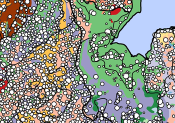 A map of GIS data showing Roberts and Wrathmell's nucleated settlements and settlement provinces, sub-provinces and local regions overlaid on terrain zones. © Historic England
The Atlas of Rural Settlement in England GIS comprises the results of two projects based on Brian K Roberts and Stuart Wrathmell’s An Atlas of Rural Settlement in England (2000).
The aim of the data conversion project was to enable the key maps of rural settlement and terrain presented in the printed Atlas to be used more effectively than before in research on landscape and settlement in England as well as in the management of the historic environment. The maps printed in the Atlas were produced digitally but were created as vector graphics files and were therefore not useable in Geographic Information Systems (GIS) software. Given the now-widespread use of GIS software in the management and study of the historic environment, as well as the availability of software such as Google Earth, that lacuna significantly restricted the use and value of the Atlas’s maps. Presenting Roberts and Wrathmell’s materials in an interactive, spatially-aware digital format, will enable a variety of users to examine, query and re-interpret Roberts and Wrathmell’s results.
The aims of the environmental analysis project were to investigate the inter-relationships of environmental factors and historic settlement organisation, and how they are expressed as regional and local variations, and to develop a new, national-scale characterisation of historic settlement organisation as it relates to the physical environment. The project combined the GIS data for historic settlement nucleation and dispersion with a range of data on environmental variables (topography, precipitation, temperature and soils) in order to explore which environmental variables (if any) appear to have had the most significant influence on regional variation in historic settlement organisation.
