Lower Palaeolithic technology, raw material and population ecology (bifaces)
Gilbert Marshall, David Dupplaw, Derek Roe, Clive Gamble, 2002. https://doi.org/10.5284/1000354. How to cite using this DOI
Data copyright © University of Southampton unless otherwise stated
This work is licensed under the ADS Terms of Use and Access.
Primary contact
Dr
Gilbert
Marshall
Royal Holloway, University of London
Egham
Surrey
TW20 0EX
England
Resource identifiers
- ADS Collection: 349
- DOI:https://doi.org/10.5284/1000354
- How to cite using this DOI
Lower Palaeolithic technology, raw material and population ecology
Gilbert Marshall, Clive Gamble, Derek Roe & David Dupplaw, 2002
Overview
Sites and artefact collections
Marshall, G.D., Gamble, C.S., Roe, D.A., and Dupplaw, D.
1.1 Outline
1.2 How to refer to the database in publications
1.3 Project personnel
1.4 Project aims
1.5 Project methods
1.6 The primary database of biface types
2.1 Cape Hangklip
2.2 Montagu Cave
2.3 Elandsfontein
2.4 Amanzi Springs
2.5 Pniel 6
2.6 Doornlaagte
2.7 The Kimberley sites
6.1 Broom Pits
6.2 Corfe Mullen
6.3 Cuxton
6.4 Bowman's Lodge
6.5 Warren Hill
6.6 Boxgrove
6.7 Foxhall Road
6.8 Kent's Cavern
1. Introduction and overview
1.1. Outline
This visual and metric database is the data component of a project funded by a major grant from the Arts and Humanities Research Board between 1999 and 2001 (Grant number AN5347/APN8525). The project was designed to examine Lower Palaeolithic technology and raw material and to use the findings to discuss aspects of population ecology during the period. The time range is from 1.5Myr to 300Kyr and includes material from Africa, Europe and the Near East. The database contains 10668 digitised images of 3556 bifaces, as well as information on provenience, raw material and standard measurements.
1.2 How to refer to the database in publications
Marshall, G.D., Gamble, C.G., Roe, D.A., and Dupplaw, D. 2002. Acheulian biface database. http://archaeologydataservice.ac.uk/archives/view/bifaces/bf_query.cfm ADS, York
1.3 Project personnel
The project was jointly directed by Clive Gamble, Centre for the Archaeology of Human Origins (http://www.arch.soton.ac.uk/Prospectus/CAHO/) at the University of Southampton UK, and Derek Roe of The Donald Baden -Powell Quaternary Research Centre (Pitt-Rivers Museum), University of Oxford, UK. The research involved museum and field visits in Africa and Europe, digital image recording and experimental stone knapping undertaken by Gilbert Marshall and Paraskevi Elefanti at the Centre for the Archaeology of Human Origins, University of Southampton. The automatic shape measurement programme was developed in collaboration with David Dupplaw from the Department of Electronics and Computer Science, University of Southampton. Advice and assistance in putting the archive on the web was provided by William Kilbride from the Archaeological Data Service, York (http://archaeologydataservice.ac.uk).
1.4 Project aims
- to document artefact variation across the Acheulian world by providing a standard digitised record of bifaces from selected sites which could serve as a reference for future researchers
- to investigate the extent to which differences in raw materials played a role in determining the shape and manufacture of bifaces
- to draw conclusions from artefact distributions concerning the demography of the Acheulian at a continental and regional scale
1.5 Project methods
At an early stage it was decided that a permanent digital record of Acheulian bifaces (handaxes, cleavers and picks) was now both possible and desirable for the following reasons:
- to enable comparisons of biface typology and technology between different areas of the Acheulian world to be made
- to commence the compilation of an easily accessible international digitised archive of a well known and widely recognised artefact type (Acheulian bifaces)
- to reduce the duplication of effort by researchers
The selection of sites and collection of information was designed to sample the variety of the Acheulian world, as represented in Africa, Europe and the Near East. Attention was paid in particular to latitude, geology and chronology as well as to palaeoecology, associated fossil hominids and the history of research at particular sites. Where possible a target of 200 bifaces per site was set, with an original target of digitising 3000 bifaces.
1.6 The primary database of biface types
The archive consists of those bifacially worked artefacts originally defined as handaxes, cleavers, picks and knives by Kleindienst (1961, 1962). This scheme is outlined below using a series of tools from the Montagu Cave collection from South Africa as an example (see, § 2.2).

Handaxes are bifacially worked with convergent edges either straight or curved tending towards a more or less pointed tip. They are generally lenticular in cross section with functioning edges.
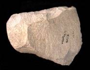
Cleavers are bifacially or sometimes unifacially worked with convergent, parallel or divergent edges and a transverse functioning bit set horizontally or obliquely, formed by the unmodified intersection of surfaces. They may be lenticular or rectangular in cross section with minimal edge shaping to create the overall form.
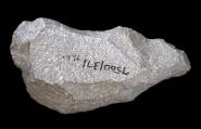
Picks are bifacially or sometimes unifacially worked with convergent irregular edges tending towards a robust more or less pointed tip. They are generally triangular in cross-section and tend to be the roughest made of all the biface forms.
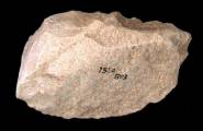
Knifes are bifacially or sometimes unifacially blunted, usually along a single long edge. In many cases the sharp edge consists of the natural unmodified intersection between dorsal and ventral surfaces. They are generally wedge shaped in cross section.
In the following text, the sites and assemblages studied are listed, with brief comments, area by area. Selected examples are illustrated, as a taste of what the data-base can show. A few major references are quoted for each main site, but this is not an exhaustive guide to the relevant literature. Many of the works cited here will in their own bibliographies lead the reader to other important sources.
References for introduction and overview:
- Kleindienst, M.R. 1961. Variability within the Late Acheulian assemblage in Eastern Africa. South African Archaeological Bulletin 16:35-52.
- Kleindienst, M.R. 1962. Components of the East African Acheulian assemblage: analytical approach. Actes du IVe Congrès Panafricain de Préhistoire et de l'étude du Quaternaire, Léopoldville 1959, 81-111.
2 South Africa
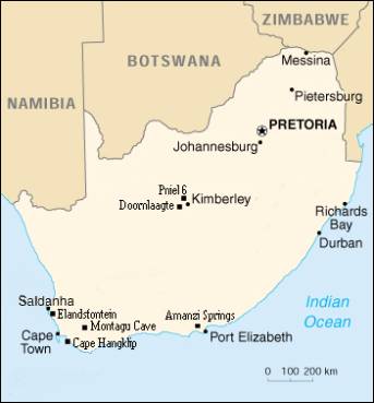
| Site or collection | Museum | Number of bifaces (n=1611) |
| Elandsfontein | South African Museum, Cape Town | 286 |
| Cape Hangklip | South African Museum, Cape Town | 268 |
| Montagu Cave | South African Museum, Cape Town | 373 |
| Amanzi Springs | Albany Museum, Grahamstown | 219 |
| Pniel 6 | McGregor Museum, Kimberley | 229 |
| Kimberley collections: Kimberley Townlands Samaria Road DeBeers Floors Sussanahkop | McGregor Museum, Kimberley | 118 29 21 51 17 |
| Doornlaagte | McGregor Museum, Kimberley | 118 |
Note that these figures refer to the collections studied and are not artefact totals for the sites.
2.1 Cape Hangklip
Facing northwest across False Bay towards Cape Town, the site of Cape Hangklip comprises an extensive scatter of Early Stone Age (ESA) artefacts and knapping waste spread across a gently sloping hillside at around 18m above sea level. The site is named after Hangklip (hanging stone) Mountain, scree from which provided the raw material for the majority of the artefacts.
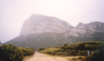
Plate 2.1.1. Cape Hangklip on a typically misty day in the Cape.
Collections of bifaces from the site were assembled by Malan and others in the 1930s, followed by excavation in the 1970s by Sampson. The artefacts were made primarily of local Table Mountain Sandstone collected on site as scree clasts, large water rolled cobbles and possibly naturally exfoliating slabs. In addition, a small number of quartz handaxes were present, the raw material for which may have been collected closer to what is now the coast where deposits of this material outcrop naturally. In addition, a very small number of handaxes were made from silcrete, the exact source of which remains unclear.
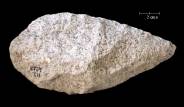
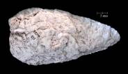
Plate 2.1.2. Two handaxes from the Cape Hangklip, the first made of Table
Mountain Sandstone and the second of quartz, which was used only rarely.
The collection consists of a range of biface forms (fig, 2.1.2.), none of which display obvious signs of having been used. Along with the significant amounts of knapping waste present, this suggests that activities at Cape Hangklip may have been geared more towards biface production than use.
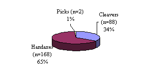
Figure 2.1.1. Bifaces proportions at Cape Hangklip.
Cape Hangklip remains undated although it is probably broadly contemporary with the site of Elandsfontein to the north of Cape Town, which has been attributed on the grounds of faunal comparison to the same time range as sites in Olduvai Gorge Beds IV and later (see § 3.1.), to between 700,000 and 400,000 years ago.
Some references for the Cape Hangklip site:
- Gatehouse, R. 1954. A Prehistoric site at Cape Hangklip. Transactions of the Royal Society of South Africa 34:84-89.
- Mabutt, J. 1951. Cape-Hangklip-a study in coastal geomorphology. Transactions of the Royal Society of South Africa 34(1):17-24.
- Sampson, C. 1962. The Cape Hangklip main site. Journal of the University of Cape Town Science Society 5:15-24.
- Sampson, C. 1972. The Stone Age Industries of the Orange River Scheme and South Africa. Memoir of the National Museum, Bloemfontein 6:40-50.
- Sampson, C. 1974. The Stone Age Archaeology of Southern Africa. Academic Press, New York.
2.2 Montagu Cave
One of the few South African cave sites with intact lower Palaeolithic horizons, Montagu is located within a small gully (pl, 2.2.1.) in the northern foothills of the Langeberg Mountains close to the Village of Montagu, approximately 130km East of Cape Town. The cave consists of a large outer chamber with a small tunnel running back into the hillside.
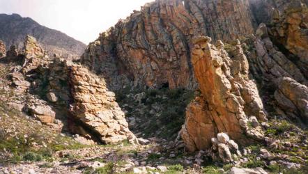
Plate 2.2.1. The northern foothills of the Langeberg, the entrance to Montagu Cave
can be seen just above the vegetation in the centre of the picture.
Rich in guano deposits, the cave was for many years mined by successive landowners, which led to the destruction of much of the upper portion of the site. Early excavations were begun in the 1920s by staff of the South African Museum in Cape Town, and were continued with much more extensive work during the 1960s by Keller. These produced a sequence of six horizons, of which the lower two, Layers 3 and 5, contained bifaces. Fauna was absent although well-preserved insect remains have been interpreted as indicating the presence of grasses, perhaps brought in as bedding. The Acheulian horizons have not as yet been satisfactorily dated although they probably post-date 600,000 years ago.
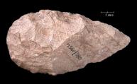
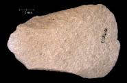
Plate 2.2.2. Handaxe and cleaver from Montagu Cave, both made of local Table
Mountain Sandstone.
The bifaces at Montagu Cave consist of a range of handaxes and cleavers (pl, 2.2.2.) along with a very few picks and knives (fig, 2.2.1.), all of which are made from locally occurring Table Mountain Sandstone.
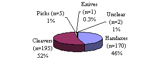
Figure 2.2.1. Biface proportions at Montagu Cave.
Most appear to have been made on flakes deliberately struck from large rock units selected from the scree deposits found in the gully below the site. However, the presence of naturally exfoliating boulders similar to those at the site of Cape Hangklip may suggest an additional source of useful blanks (pl, 2.2.3.).
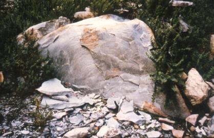
Plate 2.2.3. Large exfoliating boulder of Table Mountain Sandstone lying in the
gully below Montagu Cave, a useful source of raw material which is unlikely
to have been ignored.
To the north of the small gully in which the cave is situated lies an open valley in what is otherwise a very rugged and incised landscape. This strip of land may have served an important function as the primary foraging and hunting territory for occupants of the cave. This is supported by the density of knapping waste and the lack of use damage on the artefacts which suggest that bifaces were being manufactured in and around the cave and then carried off to be used and ultimately abandoned elsewhere.
Some references for the site of Montagu Cave:
- Deacon, H., and Deacon, J. 1999. Human beginnings in South Africa: Uncovering the Secrets of the Stone Age. Altamira Press, London.
- Keller, C. 1973. Montagu Cave in prehistory. University of California Archaeological Records 28:1-150.
- Klein, R.G. 1999. The Human Career: Human Biological and Cultural Origins. Second edition. The University of Chicago Press, Chicago.
- Sampson, C. 1974. The Stone Age Archaeology of Southern Africa. Academic Press, New York.
2.3 Elandsfontein
The farm Elandsfontein is located on the broad plain that extends north along the coast from Cape Town to Saldanha Bay. The site has produced artefacts and an important faunal assemblage as well as in 1954, an archaic Homo sapiens calvarium, (pl, 2.3.1.). Based on shape and an estimated cranial capacity of 1,225cc, the skull is broadly comparable to others from sites such as Bodo in Ethiopia, Lake Ndutu in Tanzania and Broken Hill (Kabwe) in Zambia.
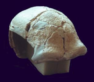
Plate 2.3.1. The Elandsfontein skull (courtesy of the South
African Museum).
Much of the fauna from the site remains in articulation, suggesting rapid burial in a wet environment. The bones were derived from twenty six species which are now extinct including short necked giraffe, sabre-toothed cats and giant buffalo. Also present were animals still in existence today although not in the area, including antelope, hippopotamus, rhinoceros and elephant.
The fauna suggests a lush, well-watered environment in which large herbivores lived alongside predators and scavengers such as sabre-toothed cats, hyenas and hominids. Comparisons between Elandsfontein and other sites with fauna such as some of those at Olduvai Gorge in Tanzania, Olorgesailie in Kenya and Bodo in Ethiopia suggest that the artefacts and fauna at Elandsfontein were accumulating between 700,000 and 400,000 years ago.
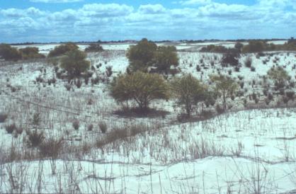
Plate 2.3.2. A view across the shifting dunes of Elandsfontein.
The area is now covered in drifting sand, the movement of which periodically exposes fauna and stone tools. Recent attempts to stabilise the area through planting has been partially successful, although inevitably this has led to a decline in numbers of new discoveries at the site. Artefacts range from the Early Stone Age bifaces to much more recent glazed pottery and clay pipes all from what are essentially mixed ablation surfaces (pl, 2.3.3.).
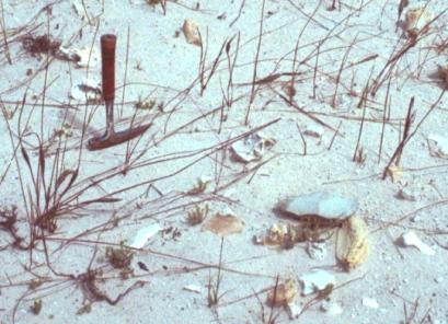
Plate 2.3.3. An ablation surface at Elandsfontein with a silcrete handaxe and
bone fragments.
The biface assemblage is dominated by smaller sized handaxes, and a few cleavers (fig, 2.3.1.). Apart from small size, a distinctive characteristic of the artefacts is the diversity of raw materials from which they were made. These include silcrete, Table Mountain Sandstone (TMS), quartz porphyry and quartz, (fig, 2.3.2. and pl, 2.3.4.). None of these occur on the site, indicating that raw materials were being carried over quite long distances, something not typical of the ESA. Silcrete would have been transported at least 15km, while quartz porphyry was probably collected close to Saldanha Bay over 20km to the north.
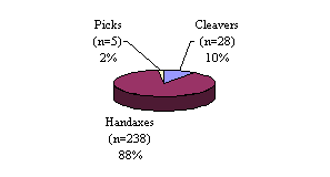
Figure 2.3.1. Biface proportions at Elandsfontein
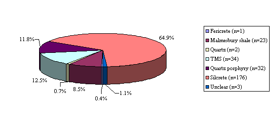
Figure 2.3.2. Raw material proportions amongst the bifaces from Elandsfontein.
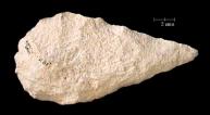
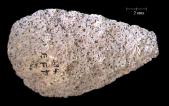
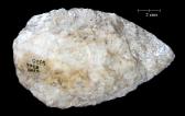
Plate 2.3.4. A selection of Elandsfontein handaxes, made of silcrete, quartz porphyry and quartz.
Some references for the site of Elandsfontein
- Avery, G. 1989. Some features distinguishing hominid and other occurrences at Elandsfontein, southwestern Cape Province. Palaeoecology of Africa 19:213-9.
- Butzer, K.W. 1973. Re-evaluation of the geology of the Elandsfontein Hopefield site, south-western Cape, South Africa. South African Journal of Science 69:234-238.
- Deacon, H., and Deacon, J. 1999. Human beginnings in South Africa: Uncovering the Secrets of the Stone Age. Altamira Press.
- Hendey, Q.B., and Deacon, H.J. 1977. Studies in palaeontology and archaeology in the Saldanha region. Transactions of the Royal Society of South Africa 42:371-81.
- Inskeep, R.R., and Hendey, Q.B. 1966. An interesting association of bones from the Elandsfontein fossil site. In: L. Diego Cuscoy (ed.) Actas del V congresso panafricano de prehistoria y de estudio del Cuaternario. Publs Mus. Arqueol., Santa Cruz de Tenerife 6:109-124.
- Klein, R.G. 1978. The fauna and overall interpretation of the "Cutting 10" Acheulian site at Elandsfontein (Hopefield), South-western Cape province, South Africa. Quaternary Research 10: 69-83.
- Klein, R.G. 1999. The Human Career: Human Biological and Cultural Origins. Second edition. The University of Chicago Press, Chicago.
- Klein, R.G., and Cruz-Uribe, K. 1991. The bovids from Elandsfontein, South Africa, and their implications for the age, palaeoenvironment, and origins of the site. The African Archaeological Review 9:21-79.
- Mabutt, J. 1956. The Physiography and Surface geology of the Hopefield Fossil Site. Transactions of the Royal Society of South Africa 35(1):21-58.
- Malan, B. 1959. The stone industry of the site at Elandsfontein, Hopefield, South Africa. Actes du IVe Congrés Panafricain de Préhistoire et de L'étude du Quaternaire Section 3:225-232.
- Sampson, C. 1974. The Stone Age Archaeology of Southern Africa. Academic Press.Singer, R., and Crawford, J. 1957. The Significance of the archaeological discoveries at Hopefield, South Africa. Journal of the Royal Anthropological Institute 88:11-19.
- Singer, R., and Wymer, J. 1968. Archaeological Investigations at the Saldanha Skull Site in South Africa. South African Archaeological Bulletin 25:63-74.
2.4 Amanzi Springs
The site of Amanzi Springs is located at an altitude of 186m above sea level on top of Amanzi Hill in the Uitenhage District, and overlooks the open floodplain of the Coega River. The site would have consisted of a series of warm sulphurous springs which, although still boggy in appearance, have largely dried up. Water for irrigation of the extensive citrus plantations of Amanzi Estates is still drawn from Amanzi Hill today, although pumped from well below the surface.
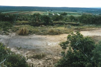
Plate 2.4.1. One of the Amanzi 'eyes', not quite a spring but still boggy and
Sulphurous.
Sustained borehole pumping elsewhere in the area has led to a fall in the level of the water table and therefore the demise of the springs. An early report during the 1920s noted the presence of artefacts following disturbance of the springs during the previous decade with attempts to increase flow. Many of these can still be found scattered across the 'eyes'. Preliminary archaeological investigation was undertaken in 1963 by Inskeep, and followed up in 1964 and 1965 by Deacon. The site produced a range of bifaces, (fig, 2.4.1.), most of which were irregular and rather crude in appearance. Moreover, compared to the other sites in the study, Amanzi produced relatively higher proportions of picks. Both probably reflect the use of Table Mountain Sandstone cobbles as raw materials, a material that is awkward in shape and difficult to work (pl, 2.4.2.).
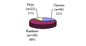
Figure 2.4.1. Biface proportions at Amanzi Springs.
One interesting aspect of the Amanzi Springs collection was the high proportion of artefacts with significant edge damage suggestive of hard scraping and crushing. Although fauna was lacking, organic material such as wood in particular particular has been well preserved at the site (Deacon 1970). Amanzi Springs remains as yet undated.
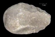
Plate 2.4.2. Amanzi Springs biface showing the limitations of the rolled cobble raw materials.
Some references for the site of Amanzi Springs
- Deacon, H. 1970. The Acheulian occupation at Amanzi Springs Uitenhage district, Cape Province. Annals of the Cape Provincial Museums (Natural history) 8(2):89-189.
- Inskeep, R. 1965. Earlier Stone Age occupation at Amanzi: A preliminary investigation. South African Journal of Science 61:229-242.
- Sampson, C. 1974. The Stone Age Archaeology of Southern Africa. Academic Press.
2.5 Pniel 6
The Pniel 6 assemblage was collected from derived gravels by Beaumont of the McGregor museum in Kimberley, from the south bank of the Vaal River approximately 10km from Barkly West. First worked for diamonds in the early 1920s, these gravels were dredged up during the construction of cofferdams and subsequent prospecting.
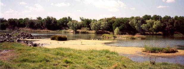
Plate 2.5.1. The Vaal River and the remains of the cofferdam from which the Pniel 6 assemblage was collected by Peter Beaumont of the McGregor Museum in Kimberley.
Detailed archaeological work was begun in 1984 by Beaumont and has produced a significant series of sites along this stretch of the river, including both derived and possibly in-situ occurrences. The bifaces consist of a range of handaxes and cleavers (fig, 2.5.1.) made of locally occurring outcrops and boulders of andesite as well as derived hornfels. A significant degree of standardisation was being achieved in both materials, suggestive of an element of pre-shaping or even Levallois type blank production.
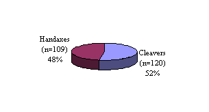
Figure 2.5.1. Biface proportions at Pniel 6.
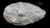
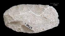
Plate 2.5.2. A handaxe and cleaver from the Pniel 6 collection, both made on large
andesite flakes.
The presence of Victoria West and other types of andesite cores in particular, all of which indicate shaping prior to the blank being detached, may account for much of this standardisation within the Vaal River collections (pl, 2.5.2.). Similar levels of standardisation appear to have been achieved with the very much smaller hornfels handaxes, and very rare cleavers. In fact the hornfels bifaces from Pniel 6 are virtually indistinguishable from those from the Kimberly sites (see § 2.7), which have elsewhere and still controversially been defined as Fauresmith. The derived nature of the Pniel 6 collection means that it is impossible to decide whether the andesite and hornfels components represent particular parts of a contemporary toolkit. New work at the nearby site of Canteen Kopje will hopefully provide a fuller picture, and possibly some dates. For an introduction to Canteen Kopje see: http://www.museumsnc.co.za/aboutus/depts/archaeology/canteenkopje.html
Some references for the Vaal River sites
- Deacon, H., and Deacon, J. 1999. Human beginnings in South Africa: Uncovering the Secrets of the Stone Age. Altamira Press.
- Beaumont, P. 1990. Canteen Koppie. In P. Beaumont and D, Morris (eds.) Guide to the Archaeological Sites in the Northern cape, 14-16. McGregor Museum, Kimberley.
- Cooke, H. 1946. The development of the Vaal River and its deposits. Transactions of the geological Society of South Africa 49:243-259.
- Goodwin, A.J.H., and van Riet Lowe, C. 1929. The Stone Age Cultures of South Africa. Annals of the South African Museum 27:1-289.
- Humphreys, A.J.B. 1969. Later Acheulian or Fauresmith? A contribution. Annals of the Cape Provincial Museums (Natural History) 6(10):87-101.
- McNabb, J. 2001. The shape of things to come. A speculative essay on the role of the Victoria West phenomenon at Canteen Koppie, during the South African Earlier Stone Age. In S. Milliken and J. Cook (eds.) A very remote period indeed: Papers on the Palaeolithic presented to Derek Roe, 37-46. Oxbow Books, Oxford.
- Malan, B. 1947. Flake tools and artefacts in the Stellenbosch-Fauresmith transition in the Vaal River valley. South African Journal of Science 43:350-362.
- Partridge, T., and Brink, A. 1967. Gravels and terraces of the Lower Vaal River Basin. South African Geographical Journal 49:21-38.
- Sampson, C. 1972. The Stone Age Industries of the Orange River Scheme and South Africa. Memoir of the National Museum, Bloemfontein 6:40-50.
- Sampson, C. 1974. The Stone Age Archaeology of Southern Africa. Academic Press, New York.
- Söhnge, P., Visser, D., van Riet Lowe, C. 1937. The geology and archaeology of the Vaal River Basin. Memoirs of the Geological Survey of the Union of South Africa 35:1-184.
- Van Riet Lowe, C. 1952. The Vaal River chronology: An up-to-date summary. South African Archaeological Bulletin 7(29):135-149.
- Volman, T.P. 1984. Early prehistory of Southern Africa. In R.G. Klein (ed.) Southern African Prehistory and Palaeoenvironments, 169-220. Balkema, Rotterdam.
2.6 Doornlaagte
The site of Doornlaagte is located 42km due west of Kimberly on the road to Schmidtsdrif and was discovered during quarrying on the farm Doornlaagte in 1962. Work was stopped and the site investigated early in 1963 by Mason and others. The site consisted of a lag deposit of many tens of thousands of artefacts representing the residue of occupation at the edge of a pan. Pans are water filled shallow depressions drained internally and through evaporation. The artefacts including bifaces, cores, anvils and a high proportion of knapping waste, which were all encased within white calcareous sediments or calcretes.
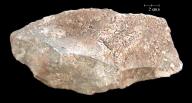
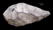
Plate 2.6.1. A cleaver and handaxe from Doornlaagte, both made of andesite.
In the absence of fauna or other organic residues, the nature of activities at the site remain unclear, although the presence of water appears to have been an important factor, along with the easy availability of large blocks of usable andesite. The assemblage is quite different from those of the Vaal River to the north, including Pniel 6 (see §2.5). Although Pniel was dominated by andesite, there was also a sizable component of hornfels present. At Doornlaagte however, no hornfels artefacts were found, and those made of andesite were much cruder and only minimally shaped (pl, 2.6.1.). Convincing evidence for pre-shaping of cores prior to blank removal is absent, as are Victoria West type cores. Abandonment of the site was probably due to desiccation of the area, probably sometime between 1 million and 500,000 years ago.
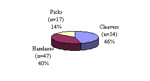
Figure 2.6.1. Biface proportions at Doornlaagte.
Some references for the site of Doornlaagte
- Deacon, H., and Deacon, J. 1999. Human beginnings in South Africa: Uncovering the Secrets of the Stone Age. Altamira Press, London.
- Butzer, K.W. 1974. Geo-archaeological interpretation of Acheulian Calc-Pan sites at Doornlaagte and Rooidam (Kimberley, South Africa). Journal of Archaeological Science 1: 1-25.
- Mason, B.D. 1966. The excavation of Doornlaagte Earlier Stone Age camp, Kimberley District. Actas del V Congreso Panafricano de Prehistoria y de estudio del Cuaternario, Tenerife 1963. 2:187-188.
- Sampson, C. 1972. The Stone Age Industries of the Orange River Scheme and South Africa. Memoir of the National Museum, Bloemfontein 6:40-50.
- Sampson, C. 1974. The Stone Age Archaeology of Southern Africa. Academic Press, London.
2.7 The Kimberley sites
'The Kimberley sites' refers to a series of four smaller assemblages which were found during development and mining in the Kimberley area. None of these collections has any clear contextual information beyond general location. The reason for studying them and the justification for grouping them together was their typological similarity, in particular their
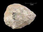
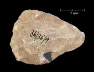
Plate 2.7.1. Two small hornfels handaxes from the Kimberley collections, both
measure just 62mm in length.
distinctive size and shape, the low proportions of cleavers (pl, 2.7.1., and fig, 2.7.1.) and the exclusive use of hornfels. Collections of this type have traditionally been described as Fauresmith, and have been attributed to the very latest stages of the African Acheulian probably around or slightly before 250,000 years ago.

Figure 2.7.1. Biface proportions in the combined Kimberley collection.
Some references for Fauresmith sites around Kimberley:
- Deacon, H., and Deacon, J. 1999. Human beginnings in South Africa: Uncovering the Secrets of the Stone Age. Altamira Press.
- Goodwin, A.J.H., and van Riet Lowe, C. 1929. The Stone Age Cultures of South Africa. Annals of the South African Museum 27:1-289.
- Humphreys, A.J.B. 1969. Later Acheulian or Fauresmith? A contribution. Annals of the Cape Provincial Museums (Natural History) 6(10):87-101.
- Sampson, C. 1974. The Stone Age Archaeology of Southern Africa. Academic Press, London.
3 Tanzania
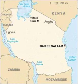
3.1 Olduvai Gorge
http://www.leakeyfoundation.org/
| Olduvai Gorge site subdivisions (Korongo is Swahili for gully) | Museum | Number of bifaces(n=256) |
| CMK (Catherine Martin Korongo) | National Museum, Dar es Salaam | 1 |
| DC (Donald's Cliff) | National Museum, Dar es Salaam | 1 |
| DK I (Douglas (Leakey) Korongo) | National Museum, Dar es Salaam | 4 |
| EF-HR (Evelyn Fuchs-Hans Reck) | National Museum, Dar es Salaam | 8 |
| EHK (listed in museum archive but no site reference in Leakey 1967:101-107) | National Museum, Dar es Salaam | 1 |
| FC (Fuch's Cliff) | National Museum, Dar es Salaam | 2 |
| FLK (Frida Leakey Korongo) | National Museum, Dar es Salaam | 2 |
| HEK (listed in museum archive but no site reference in Leakey 1967:101-107) | National Museum, Dar es Salaam | 1 |
| HK (Hopwood's Korongo) | National Museum, Dar es Salaam | 151 |
| HWK (Henrietta Wilfrida Korongo) | National Museum, Dar es Salaam | 1 |
| JK (Juma's Korongos) | National Museum, Dar es Salaam | 5 |
| JK2 (Juma's Korongos) | National Museum, Dar es Salaam | 2 |
| LK (Leakey's Korongo) | National Museum, Dar es Salaam | 8 |
| MK (MacInnes Korongo) | National Museum, Dar es Salaam | 31 |
| MNK (Mary Nicol Korongo) | National Museum, Dar es Salaam | 21 |
| MUK (listed in museum archive but no site reference in Leakey 1967:101-107) | National Museum, Dar es Salaam | 1 |
| SHK (Sam Howard Korongo) | National Museum, Dar es Salaam | 3 |
| SWK (Sam White Korongo) | National Museum, Dar es Salaam | 2 |
| TK (Thiongo Korongo) | National Museum, Dar es Salaam | 7 |
| TK (Thiongo Korongo) 'Fish Gully' | National Museum, Dar es Salaam | 2 |
| VEK (Vivian Evelyn (Fuchs) Korongo) | National Museum, Dar es Salaam | 2 |
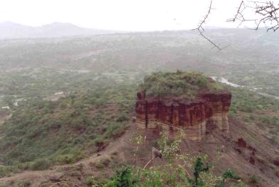
Plate 3.1. Looking out across Olduvai Gorge on a wet day in December
2001, the quartzite raw material source of Naibor Soit (white hill) can be
seen in the upper left of the picture.
The archaeological research area known as Olduvai Gorge comprises a 50km long major erosion feature comprising the Main and Side Gorges, which lie along the western edge of the eastern Rift Valley in northern Tanzania. The vertical succession consists of almost 100m of deposits that have been divided up into a total of seven main units, Beds I to IV, Masek, Ndutu and Naisiusiu. The present form of the Gorge is the result of a complex interplay between basin deposition followed by tectonics and uplift changing drainage dynamics and faulting on a more local scale. The earlier sites were laid down during a depositional period dating from before 1.8 million years ago when much of the Olduvai Basin was covered by a shallow lake. Faulting led to a shift in position of the lake, followed by increased down-cutting. Post Bed II sediments from around 1,2 million years ago were laid down as stream deposits, to which a major contribution of volcanic ash-falls was added. Recent Palaeomagnetic studies suggest that the Masek Beds may have been formed as early as from 1 million and 400,000 years ago, with the subsequent Ndutu Beds laid down from the latter date until 75,000 years ago, followed by the Naisiusiu Beds between 22,000 and 15,000 years ago. Important hominid fossil finds include Paranthropus boisei and Homo habilis in Beds I and II, Homo erectus or ergaster in Beds II, III and IV, and early Homo sapiens in Masek and Lower Ndutu. In addition to hominid fossils, large assemblages of fauna typical of both lakeside and savannah species were found.
Beds I and the lower part of bed II contained Oldowan artefacts, with a few examples of what Leakey described as proto bifaces. Middle and Upper Bed II to Bed IV contained Developed Oldowan B and C, and Acheulian. Developed Oldowan B and C assemblages do contain bifaces but these are variable in morphology and very much smaller than those from the Acheulian assemblages. They are also made from cobbles rather than flake blanks. The Masek Beds contain Acheulian artefacts, while the developed Oldowan disappears. The final Ndutu and Naisiusiu horizons contain Middle Stone Age and later artefacts. Raw materials being exploited at Olduvai include quartzite, basalt, trachyandesite and phonolite (pl, 3.1.1. to 3.1.4.). During Bed I the tendency was to use locally occurring cobbles of nephelinite and basalt that would have been available within streams feeding the lake. However from Upper Bed II to Bed IV regular use was made of materials collected from up to 13km away. White quartzite was readily available from Naibor Soit, a Precambrian inselberg situated close to the most densely occupied area.
The artefacts included in this study so far were those collected by Louis Leakey during 1931 and 1935, which are held by the National Museum of Tanzania in Dar es Salaam. The more substantial collections generated during later work, in many cases during controlled excavations, are now held in Nairobi, Kenya. This means that many of the assemblages included in this study are disappointingly small. However the catalogue is of use as a record of some of Leakey's earliest work at the site as well as of the research potential of material currently held in Tanzania, and it may in due course be possible for the main Olduvai collections to be added to this data base. Details of the individual sites listed above will be found in the works listed below.
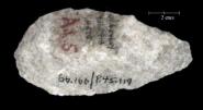
Plate 3.1.1. Quartzite handaxe from
HK, Bed IV.

Plate 3.1.2. Basalt cleaver from
EF-HR, Bed III.
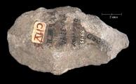
Plate 3.1.3. Trachyandesite handaxe
from DK1, Bed II.

Plate 3.1.4. Phonolite handaxe from
HK, Bed IV.
Some references for Olduvai Gorge
- Hay, R.L. 1976. Geology of the Olduvai Gorge: A study of sedimentation in a semiarid basin. University of California Press, Berkeley.
- Klein, R. 1999. The Human Career, Human Biological and Cultural Origins. Second edition. University of Chicago Press, Chicago.Leakey, L.S.B. 1967. Olduvai Gorge, 1951-61: A preliminary report of the geology and fauna. Cambridge University Press, Cambridge.
- Leakey, M.D. 1979. Olduvai Gorge, my search for Early Man. Williams Collins, London.
- Leakey, M.D., and Roe, D.A. 1994. Olduvai Gorge: Excavations in Beds III, IV and Masek Beds. 1968-1971. Cambridge University Press, Cambridge.
- Tamrat, E., Thouveny, N., Taïeb, M., and Opdyke, N.D. 1995. Revised magnetostratigraphy of the plio-Pleistocene sedimentary sequence of the Olduvai Formation (Tanzania). Palaeogeography, Palaeoclimatology, Palaeoecology 114:273-283.
4 Morocco
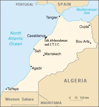
4.1 The Casablanca sites
| Site name | Museum | Number of bifaces (n=332) |
| S.T.I.C | Musee De L'Homme, Paris | 116 |
| Grotte des Ours | Musee De L'Homme, Paris | 87 |
| Cap Chatelier | Musee De L'Homme, Paris | 102 |
| Grotte des Littorines | Musee De L'Homme, Paris | 14 |
| Cunette | Musee De L'Homme, Paris | 13 |
Work was begun on the harbour at Casablanca in 1907 and resulted in extensive quarrying 7km south west of the city at the sites of Sidi-Abderrahman (Ancienne Exploitation and Cunette), Sidi-Abderrahman Extension, Carrière (quarry) de la S.T.I.C and Carrière Thomas. During quarrying work, a series of artefact and fauna-rich littoral deposits were found. Within these was found abundant evidence for human occupation including artefacts, animal bones and hominid fossils. The Grotte des Littorines, at the south-western end of Sidi Abderrahman Cunette, produced a few mandibular fragments, while Carrière Thomas approximately 2km to the south-west produced a mandible and cranial fragments. These fossils probably represent Homo erectus or archaic sapiens types in the broad sense, comparable in form and chronology with those from sites such as Elandsfontein in South Africa or Broken Hill in Zambia, both thought to date from between 600,000 and 400,000 years ago.
The biface collection included in this study was that used by Biberson in his initial formulation of his Casablanca chronology. In addition to material from the Grotte des Littorines mentioned above, bifaces from three other locations were studied, two located in the Cunette trench and a final one at the S.T.I.C. quarry approximately 2km to the south-west. Cunette was a deep trench approximately 45m wide and 600m long running northeast from the northern edge of the main quarry at Sidi Abderrahman Ancient Exploitation. The trench cut through a series of buried deposits including those of the Grotte des Ours located at the north-eastern end of Cunette and Cap Chatelier located within a narrow side trench half way along. A fifth small group of artefacts could only be attributed to Cunette generally. The bifaces consist of a wide variety of types of variable quality. Although not necessarily fully representative of the range present at each site, the specimens figured below (pl, 4.1.1. to 4.1.4.) are certainly some of the better examples from each. Those from S.T.I.C and Grotte des Ours appear the most crude although it should be noted that both assemblages were dominated by the use of cobbles of El Hank quartzite, an awkward material to work. Although the sites of Cap Chatelier and Grotte des Littorines contained a component of similar cobble based artefacts, they also produced a number of much better examples, many of which were probably made on flake blanks of a pinkish quartzite not noted in either the S.T.I.C. or Grotte des Ours collections. Whether this situation is reflecting temporal differences or simply differing access to raw materials, remains open to question.
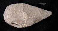
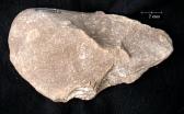
Plate 4.1.1 Handaxes from the S.T.I.C. quarry.
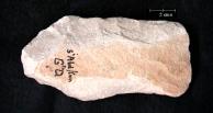

Plate 4.1.2. Cleaver and handaxe from the Grotte des Ours, Cunette, Sidi-Abderrahman.
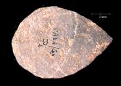
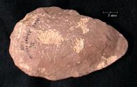
Plate 4.1.3. Handaxes from Cap Chatelier, Cunette, Sidi-Abderrahman.
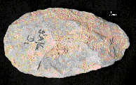
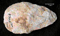
Plate 4.1.4. Handaxes from the Grotte des Littorines, Cunette, Sidi-Abderrahman.
Some references for the Casablanca sites
- Biberson, P. 1956. Le Gisement De L'Atlanthrope De Sidi Abderrahman (Casablanca). Bulletin D'Archéologie Marocaine.
- Biberson, P. 1961. Le Paléolithique Inférieur Du Maroc Atlantique. Publications Du Service Des Antiquites Du Maroc, Fascicule 17, Rabat.
- Biberson, P. 1964. La Place des hommes du Paléolithique marocain dans la chronologie du Pléistocène atlantique. Anthropologie 68:475-526.
- Klein, R. 1999. The Human Career, Human Biological and Cultural Origins. Second edition. University of Chicago Press, Chicago.
- Raynal, J.-P., Geraads, D., Magoga, L., El Hajraoui, A., Texier, J.-P., Lefevre, D., and Sbihi-Alaoui, F.-Z. 1993. La Grotte des Rhinocéros (Carrière Oulad Hamida 1, anciennement Thomas III, Casablanca), nouveau site acheuléen du Maroc atlantique. Comptes Rendus de l'Académie des Sciences, Paris, series 2, 316:1477-1483.
- Raynal, J.-P., Magoga, L., Sbihi-Alaoui, F.-Z., and Geraads, D. 1995. The earliest occupation of Atlantic Morocco: The Casablanca evidence. In W. Roebroeks and T. van Kolfschoten (eds.) The earliest occupation of Europe, 255-262. University of Leiden, Leiden.
5 Israel
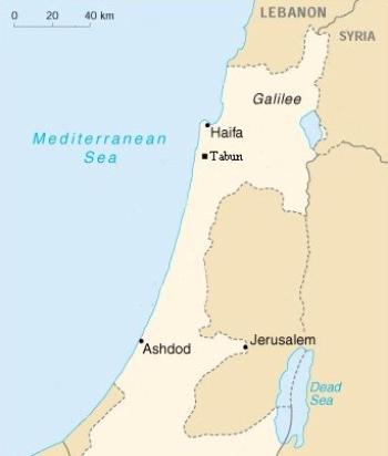
5.1 Tabun
| Site name | Museum | Numberof bifaces |
| Tabun (layers E and F) | Cambridge Museum of Archaeology and Anthropology | 190 |
Tabun (Oven) Cave is located within Mount Carmel to the south of Haifa, at a height of approximately 45m above present sea level, facing northwest across the Mediterranean coastal plain. The site was investigated between 1929 and 1934 by Garrod, by Jelinek between 1967 and 1972 with current work being carried out by Ronen. Dorothy Garrod's early excavations revealed a deep stratigraphic sequence within which she defined seven main horizons, Layers A to G. The assemblages of B, C and D are all Middle Palaeolithic, with important differences, but Garrod identified a distinct change between Layers D and E in terms of both stone tools and fauna. The fauna is significantly different and handaxes are more common in layer E, which is regarded as Acheulio-Yabrudian. The lithic raw materials used at Tabun were exclusively locally occurring flint nodules, the small size and often awkward shape of which must have made working them quite difficult. The second handaxe in (pl, 5.1.1.) illustrates how, despite the need to use awkward shaped raw materials, the basic handaxe shape was being maintained. Layer F produced an Acheulian assemblage where scrapers were rare, while Layer G, of which Garrod only exposed a small area, rested on bedrock at the base of the sequence and contained a rather poor collection of flakes. More recent work on the nature of the sediments within the cave has shed light on its position relative to the coastline. As the lower Layers G, F and E were laid down, the sea would have been near to the mouth of the cave with wind blown sands making up a large proportion of the fill. A sample from the middle of this sequence from Layers D to the base of the cave has been TL dated to 350,000 years ago. Increasing levels of silt and a corresponding decline in sand point to the retreat of the coast, which would have been some distance from the Cave when Layers E and then D were laid down. At the same time subsidence within the cave was occurring, probably as a result of the lowering of the water table, again pointing to the retreat of the coastline. Layer C has been TL dated to 170,000 years ago, 100,000 years ago by Uranium series and 125,000 years ago by ESR. The more recent Level B has been ESR dated to 80,000 years ago and 50,000 years ago by Uranium series.
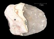
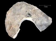
Plate 5.1.1. Two small flint handaxes from Layer E at Tabun, the right hand example
in particular shows the considerable effort made producing the classic shape despite
raw materials.
Layers E and F at Tabun were extremely rich in flint artefacts. Garrod did not preserve all those she excavated, and distributed those she kept amongst the many different institutions which had supported her work. The database offers a tiny sample, therefore, using only the material now at Cambridge University. It would be possible for much more of Tabun E and F material to be added in the future, when time and funding allows.
Some references for the site of Tabun
- Albert, R.M., and Lavi, O., and Estroff, L., and Weiner, S. 1999. Mode of occupation of Tabun cave, Mt Carmel, Israel during the Mousterian period: A study of the sediments and phytoliths. Journal of Archaeological Science 26:1249-1260.
- Garrod, D.A.E. 1934. Excavations at the Wady al-Mughara (Palestine) 1932-33. Bulletin of the American School of Prehistoric Research 10:7-11.
- Garrod, D.A.E. 1935. Excavations in the Mugharet et-Tabún (Palestine) 1934. Bulletin of the American School of Prehistoric Research 11:54-58.
- Garrod, D.A.E., and Bate, D.M.A. 1937. The Stone Age of Mount Carmel. University Press, Oxford.
- Jelinek, A.J. 1981. The Middle Palaeolithic in the Southern Levant from the perspective of the Tabun Cave. In J. Cauvin and P. Sanlaville (eds.) Prehistoire du Levant, 265-280. CNRS, Paris.
- Klein, R. 1999. The Human Career: Human Biological and Cultural Origins. Second edition. The University of Chicago press, Chicago.
6 England
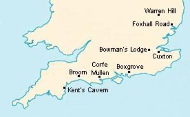
| Site name | Museum | Number of bifaces (n=1167) |
| Broom Pits | British Museum, London | 253 |
| Corfe Mullen | British Museum, London | 138 |
| Cuxton | British Museum, London | 214 |
| Bowman's Lodge | British Museum, London | 29 |
| Warren Hill | British Museum, London | 341 |
| Boxgrove | University College, London | 183 |
| Foxhall Road | British Museum, London | 5 |
| Kent's Cavern | British Museum, London | 4 |
6.1 Broom Pits
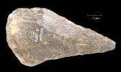
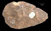
Plate 6.1. Two handaxes of Greensand chert from the Broom Pits.
The Broom gravel pits are located on the edge of the small hamlet of Broom on the east bank ofthe river Axe near Axminster between the counties of Dorset and Devon. Many thousands of handaxes along with irregularly worked pieces, cores and debitage were collected from the quarries during the nineteenth and twentieth centuries. Broom is the largest westerly Acheulian site in the United Kingdom and also one in which flint use was rare. The majority of the artefacts are made from Greensand Chert with a few made of finer grained flint. They range from crude almost pick forms to very well shaped and thinned examples (pl, 6.1.). Although rare, flint does occur naturally within the Axe River gravels therefore accounting for the low level background of flint bifaces in the collections. Broom was defined by Roe (1968) as an intermediate or generalised site with no clear preference amongst the group for either pointed or ovate types, but he did not believe the material he studied was likely to be a single unmixed assemblage. The main Broom pit is still in existence although it now serves as a farmyard.
Some references for the site of Broom:
- Green, C.P. 1988. The Palaeolithic site of Broom, Dorset, 1932-41: from the record of C.E. Bean, Esq., F.S.A. Proceedings of the Geologists' Association 99:173-180.
- Hawkes, C.F.C. 1943. Two Palaeoliths from Broom, Dorset. Proceedings of the Prehistoric Society 9:48-52.
- Reid Moir, J. 1936. Ancient man in Devon. Proceedings of the Devon Archaeological Exploration Society 2:264-275.
- Roe, D.A. 1968. British Lower and Middle Palaeolithic handaxe groups. Proceedings of the Prehistoric Society 34:1-82.
- Roe, D.A. 1981. The Lower and Middle Palaeolithic Periods in Britain. Routledge, London.
- Shakesby, R. A., and Stephens, N. 1984. The Pleistocene Gravels of the Axe valley, Devon. Report of the Transactions of the Devon Association for the Advancement of Science 116:77-88.
- Wymer, J. 1999. The Lower Palaeolithic occupation of Britain. Wessex Archaeology, Salisbury.
6.2 Corfe Mullen
Located near Wimborne Minster in Dorset, Corfe Mullen produced bifaces from two pits within valley gravel deposits of a tributary of the River Avon. The gravels appear to have been deposited within a small valley formed by a tributary of the River Avon. At the Railway Ballast Pit the industry consisted of crude pointed often elongated handaxes (pl, 6.2.1.) along with better made ovates, while at the Cogdean Pit, more refined ovate handaxes dominated the assemblage (pl 6.2.2.).

Plate 6.2.1. Elongate handaxe from the Railway Ballast Pit, Corfe Mullen.
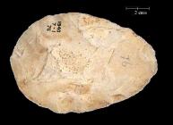
Plate 6.2.2. Well made ovate handaxe
from the Cogdean Pit, Corfe Mullen.
Calkin and Green were able to demonstrate that the more elongate handaxes from the Railway Ballast Pit were derived from an earlier context that the better made ovates. They attributed the better made ovates from the Railway Ballast Pit to the Hoxnian, while the Cogdean pit was attributed to the later Ipswichian or a Wolstonian interstadial. In fact the dating is not well established, and cannot at present be clearly stated in terms of oxygen isotope stages (OIS).
Some references for the site of Corfe Mullen:
- Calkin, J.B., and Green, J.F.N. 1949. Palaeoliths and terraces near Bournemouth. Proceedings of the Prehistoric Society 15:21-37.
- Roe, D.A. 1968. British Lower and Middle Palaeolithic handaxe groups. Proceedings of the Prehistoric Society 34:1-82.
- Roe, D.A. 1975. Some Hampshire and Dorset handaxes and the question of 'early Acheulian' in Britain. Proceedings of the Prehistoric Society 41:1-9.
- Roe, D.A. 1981. The Lower and Middle Palaeolithic Periods in Britain. Routledge, London.
- Wymer, J. 1999. The Lower Palaeolithic occupation of Britain. Wessex Archaeology, Salisbury.
6.3 Cuxton
Located at approximately 18m O.D. in the garden of the Cuxton rectory near Rochester in Kent, the site was excavated in 1962-3 by Tester, producing a rich Acheulian assemblage of handaxes, flake-tools, cores and debitage that may date to OIS 11 and possibly 10.
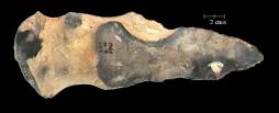
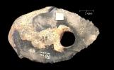
Plate 6.3. Characteristic elongate and irregular handaxes from Cuxton.
The artefacts were recovered from the top of essentially undisturbed gravels at approximately 15m O.D. on a chalk spur formed by the intersection between the River Medway and one of its tributaries. The majority of the artefacts were fresh although some were rolled suggesting at least some degree of reworking of the deposit. Many were elongate and pointed typical of artefacts made on local nodular flint (pl, 6.3.), while both illustrate nicely the limitations of some of the raw materials being used.
Some references for the site of Cuxton:
- Ashton, N., and McNabb, J. 1994. Bifaces in perspective. In N, Ashton and A, David (eds.) Stories in Stone. Lithic Studies Society Occasional Papers 4:182-191.
- Roe, D.A. 1968. British Lower and Middle Palaeolithic handaxe groups. Proceedings of the Prehistoric Society 34:1-82.
- Roe, D.A. 1981. The Lower and Middle Palaeolithic Periods in Britain. Routledge, London.Tester, P.J. 1965. An Acheulian site at Cuxton. Archaeologia Cantiana 80:30-60.
- Wymer, J. 1999. The Lower Palaeolithic occupation of Britain. Wessex Archaeology, Salisbury.
6.4 Bowman's Lodge
P.J. Tester assembled this collection during commercial quarrying at the Bowman's Lodge Pit just west of Dartford in Kent. Artefacts including bifaces, large numbers of flakes and cores were
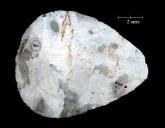
Plate 6.4. Finely made handaxe
from Bowman's Lodge.
recovered from the upper surface of the 27m to 30m terrace gravel, which were covered by a largely undisturbed loam deposit. The bifacial component of the assemblage included well made small pointed ovates, many twisted in profile and with tranchet finishing (pl, 6.4.). The loam deposits covering the artefacts and terrace gravel appear to be synchronous with those of the Upper Loam from the Barnfield (Swanscombe) Pit, where pollen analysis suggests an OIS 5e interglacial date. Therefore the artefacts that were on the upper surface of the gravel must pre-date OIS 5e but be sometime later than OIS 11.
Some references for the site of Bowman's Lodge Bridgland 1994
- Roe, D.A. 1968. British Lower and Middle Palaeolithic handaxe groups. Proceedings of the Prehistoric Society 34:1-82.
- Roe, D.A. 1981. The Lower and Middle Palaeolithic Periods in Britain. Routledge, London.
- Tester, P.J. 1951. Palaeolithic flint implements from the Bowman's Lodge Gravel Pit, Dartford Heath. Archaeologia Cantiana 63:122-134.
- Tester, P.J. 1976. Further consideration of the Bowman's Lodge industry. Archaeologia Cantiana 91:29-39.
- Wymer, J.J. 1968. Lower Palaeolithic Archaeology in Britain as represented by the Thames Valley. John Baker, London.
- Wymer, J. 1999. The Lower Palaeolithic occupation of Britain. Wessex Archaeology, Salisbury.
6.5 Warren Hill
The quarry site of Warren Hill in Suffolk now consists of a grass covered moonscape of pits and ditches planted with conifers. It was one the most prolific of the British Lower Palaeolithic sites having produced many thousands of handaxes in the 19th and 20th centuries. In an elegant piece of research, Solomon argued that the deposits were glacio-fluvial rather than simply fluvial in origin, and that both heavily
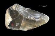
Plate 6.5.1. Rolled roughly made
Warren Hill handaxe.
abraded and fresh artefacts had been caught up within this same gravel mass. On the basis of abrasion, he organised the assemblage into four groups. His Group 1 bifaces were abraded, pear shaped, had sinuous irregular edges and were predominantly made of distinctive black flint (pl, 6.5.1.).
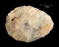
Plate 6.5.2. Lightly rolled finely made
handaxe from Warren Hill.
The lack of abrasion on some of the collection, combined with the fact that both abraded and non-abraded artefacts were found within the same gravel, suggested that the Group 1 artefacts had been rolled at an earlier stage. The less abraded and better made groups (pl, 6.5.2.) Solomon suggested were Middle to Late Acheulian in type.
Recent studies have suggested that the Warren Hill gravels are in fact fluvial, attributable to the Bytham River drainage system and that they pre-date OIS 12. However Solomon's observations remain relevant, the question that needs answering is why the correlation between shape, rolling and raw materials exists. That different raw materials were being used and then abraded differentially compared to the rest of the collection has implications for both the location and timing of the manufacture of these artefacts.
Some references for the site of Warren Hill:
- Roe, D.A. 1968. British Lower and Middle Palaeolithic handaxe groups. Proceedings of the Prehistoric Society 34:1-82.
- Roe, D.A. 1981. The Lower and Middle Palaeolithic Periods in Britain. Routledge, London.
- Rose, J. 1992. High Lodge, regional context and geological background. In N.M. Ashton, J. Cook, S.G. Lewis and J. Rose (eds.) High Lodge: Excavations by G de G Sieveking 1962-1968 and J Cook 1988. British Museum, London
- Solomon, J.D. 1933. The implementiferous gravels of Warren Hill. Journal of the Royal Anthropological Institute 63:101-110.
- Wymer, J.J., Lewis, S.G., and Bridgland, D.R. 1991. Warren Hill, Mildenhall, Suffolk (TL744743). In S.G. Lewis, C.A. Whiteman and D.R. Bridgland (eds.) Central East Anglia and the Fen Basin: Field Guide. QRA, John Winn, London.
6.6 Boxgrove
http://freespace.virgin.net/mi.pope/boxhome.htm
Located in west Sussex near Chichester, the site of Boxgrove (Amey's Eartham Pit) has produced a number of localities with exquisite preservation of both knapping debris and fauna on ancient land surfaces. The site itself is located on what would have been a flat area to the back of which the chalk cliffs were protected by a headland and sheltered tidal lagoon. In front of the cliff was a large fresh water pond that appears along with abundant sources of flint raw material in nodular and tabular form, to have been one for the primary reasons for visits by both hominids and other animals to the area. Many of the animal bones have cut marks and excavations in 1991 uncovered most of the major bones of a horse that had apparently been butchered in-situ. Elsewhere, there is evidence for butchery of both rhino and deer at Boxgrove. The presence of these animals is consistent with a climate very much like that of today with an environment of grassland, brackish and freshwater lagoons in front of chalk cliffs. In 1993 a hominid tibia of Homo cf heidelbergensis dating from around 500,000 years ago was discovered, and in 1995 two teeth were found approximately a metre below where the tibia had been recovered. The artefacts, which consist of handaxes and a large selection of associated knapping debris, were made from flint collected from the base of the chalk cliffs. The handaxes themselves consist of a range of shapes but with a strong tendency towards ovates (pl, 6.6.1.), and many have extremely sharp tips and upper edges produced by tranchet removals. The majority of the collection is extremely fresh indicating that they were found where they were discarded. Along with the undisturbed fauna, the freshness and undisturbed nature of the artefacts and knapping waste point to the immediacy of biface manufacture followed by unhindered discard after use. Microwear traces are preserved on some, and indicate use in butchery activities.
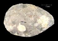
Plate 6.6.1. Finely made tranchet
handaxe from the Boxgrove collection.
The geological sequence at Boxgrove runs from the maximum of an interglacial with high sea levels and erosion of the chalk cliffs, followed by a fall and shift towards an open terrestrial environment in front. As the climate deteriorated still further, the cliffs were exposed to extremely cold conditions, which led to solifluction. The evidence suggests that the period involved was the OIS 13 interglacial followed by the OIS 12 glacial.
Some references for the site of Boxgrove:
- Pitts, M., and Roberts, M.B. 1997. Fairweather Eden: Life in Britain half a million years ago as revealed by the excavations at Boxgrove. Century, London.
- Roberts, M.B. 1986. Excavation of the Lower Palaeolithic site in Amey's Eartham Pit, Boxgrove, West Sussex: a preliminary report. Proceedings of the Prehistoric Society 52:215-246.
- Roberts, M.B., and Parfitt, S.A. 1998. Boxgrove: A middle Pleistocene Hominid site at Eartham Quarry, Boxgrove, West Sussex. English Heritage, London
- Roberts, M.B., Stringer, C.B., and Parfitt, S.A. 1994. A hominid tibia from Middle Pleistocene sediments at Boxgrove, UK. Nature. 369:311-313.
- Roberts, M.B., Gamble, C.S., and Bridgland, D.R. 1995. The earliest occupation of Europe: The British Isles. In W. Roebroeks and T. van Kolfschoten (eds.) The Earliest Occupation of Europe, 165-192. University of Leiden, Leiden.
- Stringer, C.B., Trinkaus, E., Roberts, M.B., Parfitt, S.A., and Macphail, R.I. 1998. The Middle Pleistocene human tibia from Boxgrove. Journal of Human Evolution 34:509-547.
6.7 Foxhall Road
Foxhall Road in Ipswich, Suffolk was located within a brick pit, now unfortunately completely built over. Difficulty in accessing the larger collection held by the Ipswich Museum meant that only the smaller collection held by the British Museum could be included in this study. The artefacts were dispersed within a thick deposit of brickearth filling a small lake, although records from the site may also suggest more concentrated horizons of material suggesting more substantial lakeside occupation. The bifaces consist of ovate and pointed handaxes many with
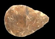
Plate 6.7. Finely made twisted handaxe
from the Foxhall Road collection.
tranchet finishing and twisted profiles, and mostly in an unrolled condition (pl, 6.7.). They were probably accumulated within the brickearth during visits to the lake during OIS 11.
Some references for the site of Foxhall Road:
- Boswell, P.G.H., and Moir, J.R. 1923. The Pleistocene deposits and their contained Palaeolithic flint implements at Foxhall Road, Ipswich. Journal of the Royal Anthropological Institute 53:229-262.
- Roe, D.A. 1968. British Lower and Middle Palaeolithic handaxe groups. Proceedings of the Prehistoric Society 34:1-82.
- Roe, D.A. 1981. The Lower and Middle Palaeolithic Periods in Britain. Routledge, London.
- Smith, R.A. 1921. Implements from Plateau Brickearth at Ipswich. Proceedings of the Geological Association of London 32:1-16.
6.8 Kent's Cavern
http://www.kents-cavern.co.uk/
Kent's Cavern is one of the few British cave sites with evidence for lower Palaeolithic presence if not occupation. The biface assemblage is small consisting of less than 20 bifaces, with only four included in this study. The site was dug between 1825 and 1829 by MacEnery and then sporadically by Godwin-Austen and then Pengelly from 1859 onwards. Rather than a single cave, the site consists of a complex of chambers and tunnels which complicates any correlations.
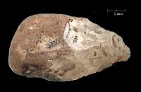
Plate 6.8. Rough cobble based handaxe
from Kent's Cavern.
The handaxes were roughly made often using flint and chert cobbles (pl, 6.8.), which to a large extent may explain their rather crude nature. Rather than evidence for Lower Palaeolithic occupation of the caves, the artefacts were probably transported into the cave as debris flows and therefore may be earlier than the deposits within which they were incorporated.
Some references for the site of Kent's Cavern:
- Campbell, J.B., and Sampson, C.G. 1971. A new analysis of Kent's cavern, Devonshire, England. University of Oregon Anthropological Papers 3.
- Cook, J., and Jacobi, R. 1998. Observations on the artefacts from the breccia at Kent's Cavern. In N. Ashton, F. Healy, and Pettit (eds.) Stone Age Archaeology: Essays in honour of John Wymer, 77-89. Lithic Studies Society Occasional Papers 6. Oxbow, Oxford.
- Roe, D.A. 1981. The Lower and Middle Palaeolithic Periods in Britain. Routledge, London.
Acknowledgments
A great number of people have been helpful at all stages of this project, and are listed below:
- Graham Avery of the South African Museum in Cape Town for allowing access to the Cape Hangklip, Montagu and Elandsfontein collections and for providing working space at the museum. Also for taking us to the site of Elandsfontein and allowing us to photograph the original Elandsfontein skull.
- Johann Binneman of the Albany Museum in Grahamstown for allowing access to the Amanzi Springs collection and for providing working space.
- Peter Beaumont of the McGregor museum in Kimberley for allowing access to the Pniel 6 collection, and those from Doornlaagte and Kimberley, and for providing working space. Also for arranging a visit to Canteen Kopje.
- Nick Ashton of the British Museum in London for allowing access to most of the British collections and for providing working space.
- Mark Roberts of University College London for allowing access to the Boxgrove collections and for providing working space.
- Christopher Chippindale of Cambridge University for allowing access to the Tabun collection and for providing working space.
- Henry deLumley of the Muse de L'Homme in Paris for allowing access to the Moroccan collections and for providing working space.
- Chediel Msuya of the Department of Antiquities in Tanzania for allowing access to the Olduvai Gorge collections, and Mr Pweka of the National Museum in Dar es Salaam for organising access and working space. Also to Felix Chami and Audax Mabula of the University of Dar es Salaam for acting as local contacts in Tanzania.
- Mr P Niven of Amanzi Estates for allowing us to visit Amanzi Springs, and Mr J Kriel of the farm Montagu for allowing us to visit Montagu Cave.
- David Dupplaw and Paul Lewis of the Department of Electronics and Computer Science at the University of Southampton for producing the measurement and shape analysis software.
- Ray Inskeep for advice and guidance on the South African collections in general.
- Naama Goren-Inbar of the Hebrew University, Jerusalem, for advice on Israeli collections.
- Lynn Wadley of the University of the Witwatersrand for allowing access to the Wonderboom collection.
- Cedric Pogenpoel of the University of Cape Town for advice on the Montagu Cave collection.
- William Kilbride of the Archaeology Data Service in York.


