
Chargrove Orchard, Land at Up Hatherley Way, Gloucestershire. Archaeological Evaluation (OASIS ID: cotswold2-324896)
Cotswold Archaeology, 2020. https://doi.org/10.5284/1076944. How to cite using this DOI
Data copyright © Cotswold Archaeology unless otherwise stated
This work is licensed under a Creative Commons Attribution 4.0 International License.

Primary contact
Cotswold Archaeology
Building 11
Kemble Enterprise Park
Cirencester
GL7 6BQ
UK
Tel: 01285 771022
Fax: 01285 771033
Resource identifiers
- ADS Collection: 3709
- DOI:https://doi.org/10.5284/1076944
- How to cite using this DOI
Introduction
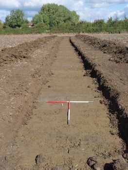
An archaeological evaluation was undertaken by Cotswold Archaeology in September and October 2017 at Chargrove Orchard, land at Up Hatherley Way, Gloucestershire. A total of sixty trenches were excavated. In the north-west extent of the site, a ditch and pit potentially dating to the medieval period were identified. Both appeared to be heavily truncated and did not correlate with previously identified geophysical survey anomalies. Remnants of undated furrows were identified across the site.
The proposed development area is approximately 27.7ha in extent and comprises seven arable fields, three pasture fields and an orchard. The site is bounded by Up Hatherley Way to the north and Chargrove Lane to the south. Open agricultural land lies to the south and west of the site. The site lies at approximately 56m AOD, and slopes gently to the west.
The underlying bedrock geology of the area is mapped as Mudstone of the Blue Lias Formation and Charmouth Mudstone (undifferentiated) of the Jurassic and Triassic Periods with no recorded superficial deposits (BGS 2017). Light yellow-grey clay was identified during the evaluation.
No prehistoric or Roman assets have been identified within the site. An investigation at Brizen Farm, Leckhampton, c.460m south-east of the site, identified a mid/late Iron Age to Roman date field system, a trackway containing Iron Age pottery and a ditch containing 2nd to 3rd century Roman pottery. In the same area, a series of undated pits and postholes were recorded. A settlement of likely Iron Age to Roman date has also been identified 545m south-east of the site: evidence included ring ditches, ditches, enclosures and pits.
