Cranborne Chase and West Wiltshire Downs AONB Historic Landscape Characterisation (HLC)

Emma Rouse, 2017. https://doi.org/10.5284/1041584. How to cite using this DOI

Digital Object Identifiers

Digital Object Identifiers (DOIs) are persistent identifiers which can be used to consistently and accurately reference digital objects and/or content. The DOIs provide a way for the ADS resources to be cited in a similar fashion to traditional scholarly materials. More information on DOIs at the ADS can be found on our help page.

Citing this DOI

The updated Crossref DOI Display guidelines recommend that DOIs should be displayed in the following format:

https://doi.org/10.5284/1041584
Sample Citation for this DOI

Emma Rouse (2017) Cranborne Chase and West Wiltshire Downs AONB Historic Landscape Characterisation (HLC) [data-set]. York: Archaeology Data Service [distributor] https://doi.org/10.5284/1041584

Data copyright © Cranborne Chase AONB unless otherwise stated

This work is licensed under the ADS Terms of Use and Access.
Creative Commons License


Historic England logo

Primary contact

Emma Rouse
Wyvern Heritage and Landscape
2 Fonthill Cottages
Hindon Lane
Tisbury
Wiltshire
SP3 6QD

Send e-mail enquiry

Resource identifiers

Digital Object Identifiers

Digital Object Identifiers (DOIs) are persistent identifiers which can be used to consistently and accurately reference digital objects and/or content. The DOIs provide a way for the ADS resources to be cited in a similar fashion to traditional scholarly materials. More information on DOIs at the ADS can be found on our help page.

Citing this DOI

The updated Crossref DOI Display guidelines recommend that DOIs should be displayed in the following format:

https://doi.org/10.5284/1041584
Sample Citation for this DOI

Emma Rouse (2017) Cranborne Chase and West Wiltshire Downs AONB Historic Landscape Characterisation (HLC) [data-set]. York: Archaeology Data Service [distributor] https://doi.org/10.5284/1041584

Overview

Cranborne Chase and West Wiltshire Downs AONB Historic Landscape Characterisation (HLC)

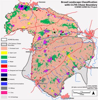
The collection consists of a GIS layer (HLC dataset) with associated report.

The HLC dataset is created using a desk-based programme of GIS mapping and analysis which draws on a wide variety of data sources. These include modern maps, historic maps, aerial photographs, place name studies, SMR data and local archaeological and historical knowledge and research. These sources are used to identify and group archaeological, historic and other environmental attributes attached to land parcels. This allows the creation of multiple and hierarchical historic landscape types each with their own distinct and recognisable character. The distribution of these types can be mapped in GIS and are supported by written descriptions. HLC will form a permanent, flexible and renewable database.

The report provides an overview of the historic landscape character of the AONB, detailed descriptions for each Historic Landscape Types and information on methodology.


ADS logo
Data Org logo
University of York logo