Frontispiece
Anon. (pp. i-iv)
|
|
PDF
|
853 Kb
|
|
Contents
Anon. (pp. v)
|
|
PDF
|
760 Kb
|
|
In Memoriam Richard Bellhouse (1916-2012)
David J. Breeze (pp. 1-4)
|
|
PDF
|
997 Kb
|
|
Postglacial Environmental history of the West Cumberland Coastal Plain: New Palaeoecological Data from Gutterby .
J. Valentine, D. Murphy, J. R. Kirby, T. Clare and D. Wilkinson (pp. 5-16)
|
Abstract
Abstract
Postglacial Environmental history of the West Cumberland Coastal Plain: New Palaeoecological Data from Gutterby .
J. Valentine, D. Murphy, J. R. Kirby, T. Clare and D. Wilkinson (pp. 5-16)
This paper describes pollen and other environmental evidence from a sediment core taken from a wetland near the site of the former stone circle at Gutterby on the southern Cumbrian coastal plain. The vegetation during the early Mesolithic was relatively open with juniper but also with small amounts of pollen from various tree species. The tarn appears to have infilled to wetland by the late Mesolithic, which has implications for the landscape in which a nearby stone circle was constructed. Much of the later record appears to be missing (perhaps though subsequent peat cutting) but peat at the top of the core records a much more open landscape with probably some reedswamp. This is compatible with eighteenth-century descriptions of the site being used for collecting medical leeches.
|
PDF
|
1 Mb
|
|
The Tortie Stone Revisited .
Blaise Vyner (pp. 17-32)
|
Abstract
Abstract
The Tortie Stone Revisited .
Blaise Vyner (pp. 17-32)
The Tortie Stone is one of a growing number of rocks bearing prehistoric decoration known from Cumbria. The site was found as recently as 1987 and excavated soon afterwards. This report outlines the somewhat convoluted history of the stone and details its re-excavation.
|
PDF
|
3 Mb
|
|
A Bronze Age Cremation Cemetery at Dallam School, Milnthorpe, Cumbria .
A. Platell, B. Vyner, A. Caffell, L. Elliot, J. Mole and J. Jones (pp. 33-56)
|
Abstract
Abstract
A Bronze Age Cremation Cemetery at Dallam School, Milnthorpe, Cumbria .
A. Platell, B. Vyner, A. Caffell, L. Elliot, J. Mole and J. Jones (pp. 33-56)
This article presents the results of archaeological works conducted in advance of a development at Dallam School, Milnthorpe, Cumbria. Four cremations were identified, three clustered within 2m of each other and the fourth located 15m to the east. Two were placed in urns, the other two were unurned. Post-excavation analysis of the pottery indicated that fragments of a third urn had been recovered from a plough furrow cutting one of the other cremations. Radiocarbon dates obtained from the burials showed a considerable spread of dates. The two urned burials produced comparable dates of 1420-1260 cal BC, the unurned burial immediately to the northeast produced a date around 300 years later and the unurned burial 15m to the west produced a date 500 years earlier. There is no evidence to suggest that the cemetery was ever covered by a barrow mound or ring cairn and it therefore appears to be a flat cemetery. Although a stone-filled ditch was found in close proximity, this was linear and did not enclose the cemetery. Its relationship to the burials is unknown.
|
PDF
|
3 Mb
|
|
Archaeological Investigations on the Cumbria Institute of the Arts Campus, Stanwix, Carlisle 2004 .
John Zant and Matthew Town (pp. 57-66)
|
Abstract
Abstract
Archaeological Investigations on the Cumbria Institute of the Arts Campus, Stanwix, Carlisle 2004 .
John Zant and Matthew Town (pp. 57-66)
In 2004, Oxford Archaeology North excavated two trenches within the campus of the Cumbria Institute of the Arts at Stanwix, Carlisle, prior to construction works. The earliest archaeological features comprised a series of plough-marks, a buried turf line and a probably contemporary ditch, part of an extensive system of arable fields, known from earlier excavations in the area, that pre-dates the construction of the Hadrian's Wall frontier system in the AD 120s. Sealing these remains was a thick deposit of compacted earth and clay, the significance of which is unclear. One hypothesis is that it was associated with the construction, perhaps in the AD 160s, of a parade ground for the stone cavalry fort at Stanwix, which was the largest on Hadrian's Wall. Alternatively, it may have been deposited during construction of the Wall itself, perhaps as upcast from the Vallum ditch, which passed within 30m of the excavations.
|
PDF
|
2 Mb
|
|
Low Tide and a Red Horse: St. Cuthbert's Relics and Morecambe Bay .
Daniel W. Elsworth (pp. 67-72)
|
Abstract
Abstract
Low Tide and a Red Horse: St. Cuthbert's Relics and Morecambe Bay .
Daniel W. Elsworth (pp. 67-72)
The movement of St Cuthbert's relics during the ninth century, as told principally by the medieval historian Symeon of Durham, has one clear Cumbrian connection. The monks entrusted to their care fled west and attempted to depart by boat to Ireland from Workington, although they were forced back by a storm. The details of where they travelled soon after this event are generally vague but certain topographic elements and their arrival at a place named 'the White House' have been taken as indicating that they crossed the Solway Estuary and arrived at Whithorn. This article reconsiders the description of these events and, taking into account the unusual topography and geology of South Cumbria, places them in Morecambe Bay instead, with an alternative location for 'the White House' suggested. The difficulties of using Symeon's text, which was heavily motivated by political and ecclesiastical interests, are also discussed.
|
PDF
|
899 Kb
|
|
Medieval Ceramics from Shaw's Wiend, Appleby-in-Westmorland, Cumbria .
C. M. Brooks, M. McCarthy and M. D. Railton (pp. 73-88)
|
Abstract
Abstract
Medieval Ceramics from Shaw's Wiend, Appleby-in-Westmorland, Cumbria .
C. M. Brooks, M. McCarthy and M. D. Railton (pp. 73-88)
Two phases of archaeological investigation have been undertaken on land adjacent to Boroughgate, Appleby-in-Westmorland, which have revealed evidence for medieval and later domestic activity at the site. The archaeological features identified represent two main phases of development, relating to the occupation of two burgages in the medieval and post-medieval periods, as well as periods of apparent abandonment. A significant assemblage of medieval pottery was recovered, which points to trade links on both sides of the Pennines, but with close links to the North West, in particular with Carlisle, Dacre and Penrith. As a result of this and previous work, an Eden Valley medieval ceramic tradition is slowly beginning to emerge.
|
PDF
|
3 Mb
|
|
Excavation of Medieval Burgage Plots to the Rear of 130-136 Stricklandgate, Kendal .
S. Whitehead, D. Williams and T. Mace (pp. 89-116)
|
Abstract
Abstract
Excavation of Medieval Burgage Plots to the Rear of 130-136 Stricklandgate, Kendal .
S. Whitehead, D. Williams and T. Mace (pp. 89-116)
This article summarises the results of excavation to the rear of 130-136 Stricklandgate, Kendal, and contributes fabric descriptions and illustrates vessel forms covering the transition from medieval to post-medieval ceramic traditions in the area, which represents a primary research aim in the study of medieval ceramics. Excavation revealed both medieval and post-medieval activity at the site, which has seen occupation since at least the late twelfth or thirteenth century and, despite being at the far north end of the town, the site was evidently not on the periphery of the medieval core as might be assumed.
|
PDF
|
3 Mb
|
|
Medieval Land use in the Ancient Parish of Kirkby Kendale .
M. A. Atkin (pp. 117-138)
|
Abstract
Abstract
Medieval Land use in the Ancient Parish of Kirkby Kendale .
M. A. Atkin (pp. 117-138)
This paper uses place-names, field-names and field patterns to explore medieval land use in the ancient parish of Kirkby Kendale. The principal source is the maps and schedules of the townships of the parish made for the Kendal Corn Rent Act 1835. The Kendal Corn Rent Act aimed to commute the payment of tithes paid in goods to payment in money. This required surveyors to map and number the tithable fields of each township in the parish and to list for each field its number, owner, tenant, fieldname and a valuation for tithe. This material was explored further using William Farrer's 'Records relating to the Barony of Kendale' volumes I to III (Kendal 1923), and A.H.Smith's 'The Place-Names of Westmorland volumes 1 and 2' (Cambridge 1967), and other records in the Kendal Record Office, together with substantial fieldwork.
|
PDF
|
1 Mb
|
|
Peat Use in the Barony of Kendal, Common of Turbary and the Levens Anomaly .
Anne Hillman (pp. 139-150)
|
Abstract
Abstract
Peat Use in the Barony of Kendal, Common of Turbary and the Levens Anomaly .
Anne Hillman (pp. 139-150)
Common rights to peat were valuable in Westmorland, where there were rich deposits and a scarcity of wood. Locally, coal was of poor quality and expensive. In areas where there was no common of turbary the tenants and freeholders rented or bought peat mosses from the manorial lords. Getting peat was a communal activity and the rules and regulations set up in the manor courts were designed to encourage neighbourliness and respect towards the lords of the manors, their employees and to everyone in the community. The other priority was maintenance of the peat mosses and access roads, and the peat jurymen had severe penalties available to punish individuals who neglected the rules. Research in more southerly areas of the England shows that many common rights including those for peat, were lost as a result of parliamentary enclosure. The comparatively late date of most Westmorland parliamentary enclosures, as well as the well-preserved manorial records in the Barony of Kendal that were available to the enclosure commissioners, and the carefully-worded provisions of the awards themselves, all contributed towards the protection of turbary and also grazing rights in Westmorland into the twentieth century.
|
PDF
|
899 Kb
|
|
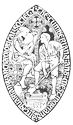
The Salkeld Screen, Carlisle Cathedral: Understanding the Iconography .
June C. F. Barnes (pp. 151-170)
|
Abstract
Abstract
The Salkeld Screen, Carlisle Cathedral: Understanding the Iconography .
June C. F. Barnes (pp. 151-170)
No records remain in Carlisle Cathedral relating to the Salkeld Screen. Therefore we must regard the screen as an historical document in itself, the deciphering of its visual imagery providing as much insight into the historic, artistic and spiritual movements of mid-sixteenth century England as from more conventional documentation. We do know from the evidence contained in the screen itself that it can be dated to between 1540 and 1547. Few such medieval screens now exist. This paper sets out to demonstrate how the thinking of the mid-sixteenth century dictated so much of the Salkeld Screen's design, iconography and symbolism, by discovering the sources from which the designs derive. Further, the intention is to show that the purpose underlying the screen is to celebrate the Tudor myth in the person of Henry VIII himself, with its allusions to both the politics and the theology of the time.
|
PDF
|
5 Mb
|
|
"And who is my neighbour?": The Methodists of Hunsonby and Winskill in Their Local Context 1821-1871 .
Lydia Gray (pp. 171-190)
|
Abstract
Abstract
"And who is my neighbour?": The Methodists of Hunsonby and Winskill in Their Local Context 1821-1871 .
Lydia Gray (pp. 171-190)
This article extends the investigation into the Methodists of Hunsonby, Cumbria, begun in my article published in CW 2012. It investigates the relationships within the parish of Addingham, near Kirkoswald, in Cumberland, between the Methodists and the Church of England, and the 'view from the vicarage', and then moves on to explain the methodology used to ascertain the names of individual Methodists which enabled me to consider them in their local village context, before finally discussing their situation in 1871.
|
PDF
|
1 Mb
|
|
Lime Burning and the Uses of Lime in the Historic County of Westmorland and Along the Pennine Edge of Cumberland .
David S. Johnson (pp. 191-214)
|
Abstract
Abstract
Lime Burning and the Uses of Lime in the Historic County of Westmorland and Along the Pennine Edge of Cumberland .
David S. Johnson (pp. 191-214)
Lime kilns are a common feature in the Cumbrian landscape but not one that has received detailed examination. Lime was an indispensable commodity in Cumbria for many centuries until the 1960s, in agriculture, building work and local craft industries. This article presents the results of a detailed field survey across the entire historic county of Westmorland and along the Pennine fringe of Cumberland, and of comprehensive archival research into the production and uses of lime. It makes comparisons - and contrasts - with the results of a similar survey in the Central Pennines. The article begins by placing lime burning within a historical context, then briefly outlines the historic use of lime across the rest of what is now Cumbria, and considers the constraints which held back large-scale lime production in the county, before going on to discuss a range of variables that help to explain the distribution and details of lime kilns in the survey area.
|
PDF
|
4 Mb
|
|
The Ethel Hedley Orthopaedic Hospital for Crippled Children, Calgarth Park, Windermere .
Paul Cheesbrough (pp. 215-232)
|
Abstract
Abstract
The Ethel Hedley Orthopaedic Hospital for Crippled Children, Calgarth Park, Windermere .
Paul Cheesbrough (pp. 215-232)
When the Ethel Hedley Hospital opened in 1920 it was one of the first hospitals in England and Wales for the management of poliomyelitis and other crippling diseases. It was founded in the wake of outbreaks of poliomyelitis in Westmorland and neighbouring counties during the previous decade and at a time when there was a growing belief that crippling diseases of childhood were both preventable and amenable to treatment. Treatment involved lengthy immobilisation of diseased joints and bed rest, often in open-air - typically for up to two years. This paper charts the hospital's 50-year history, the wider factors which influenced its establishment, the types of cases it treated and includes recollections of reatment methods of former patients and staff. It also shows how changes in disease incidence and the pattern of hospital provision led to the hospital's closure in 1970.
|
PDF
|
1 Mb
|
|
NOTES
Various. (pp. 233-264)
|
|
PDF
|
5 Mb
|
|
Three Recent Roman Finds from Burgh-by-Sands, Cumbria.
Philip Cracknell (pp. 233-237)
|
|
PDF
|
5 Mb
|
|
Excavation of Hadrian's Wall Vallum, near Millbeck Farm, Kirkandrews on Eden, Cumbria.
Ross White, Ian Hill and Tim Neighbour (pp. 238-245)
|
|
PDF
|
5 Mb
|
|
A Hoard of Denarii from Crosby, Near Maryport.
David Shotter (pp. 245-248)
|
|
PDF
|
5 Mb
|
|
A Late Roman Coin Hoard From Newby, Cumbria.
David Shotter (pp. 249-253)
|
|
PDF
|
5 Mb
|
|
A broken quern topstone from Lowther Park.
Harry Hawkins (pp. 254-255)
|
|
PDF
|
5 Mb
|
|
Cattle-droving through Cumbria, 1707-12: New Evidence from the Musgrave Estate.
Peter Roebuck (pp. 256-260)
|
|
PDF
|
5 Mb
|
|
A Pennine Fox Trap.
Graham Brooks. (pp. 260-261)
|
|
PDF
|
5 Mb
|
|
A Date for Levens Hall Ice-house.
Rob David (pp. 261-264)
|
|
PDF
|
5 Mb
|
|
Archaeological Projects in Cumbria 2012
Anon. (pp. 265-291)
|
|
PDF
|
1 Mb
|
|
List of Publications and Completed Theses on Cumberland and Westmorland 2012
Anon. (pp. 292)
|
|
PDF
|
1 Mb
|
|
General Index
Anon. (pp. 293-305)
|
|
PDF
|
948 Kb
|
|