
Day of Archaeology Archive
Lorna-Jane Richardson, Matthew Law, Andrew Dufton, Kate Ellenberger, Stuart Eve, Tom Goskar, Jess Ogden, Daniel Pett, Andrew Reinhard, 2018. (updated 2021) https://doi.org/10.5284/1048331. How to cite using this DOI
Data copyright © Individual Authors unless otherwise stated
This work is licensed under a Creative Commons Attribution-ShareAlike 4.0 International License.

Resource identifiers
- ADS Collection: 3016
- DOI:https://doi.org/10.5284/1048331
- How to cite using this DOI

Peter McKeague (RCAHMS) - East Dunbartonshire
Year: 2013 Author: Historic Environment Scotland Categories: Military, Day of Archaeology 2013, Roman
Tags: #myarchaeology, Royal Commission on the Ancient and Historical Monuments of Scotland, Roman Fort, Glasgow, New Kilpatrick cemetery, New Kilpatrick, Archaeology, Scottish Archaeology, Antonine Wall, RCAHMS, East Dunbartonshire, Bearsden, Roman archaeology
| Historic Environment Scotland (2013): Peter McKeague (RCAHMS) - East Dunbartonshire. https://doi.org/10.5284/1079773 | 417 Kb | ||
The images from the original post have been archived and are also available to download. In certain cases images can not be disseminated if they do not adhere to our sensitive data policy.

|
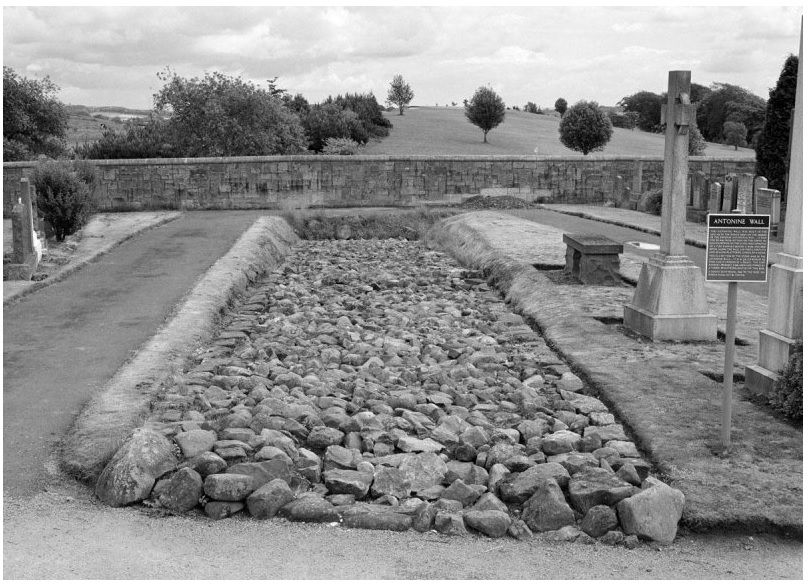
To the NE of Glasgow, the Antonine Wall snakes through the modern landscape of Bearsden. Two short stretches of the wall are visible at New Kilpatrick cemetery and visitors may also explore the remains of the Roman Bath House at Bearsden, part of the Roman fort now buried under houses (doa_image6839.jpg) |
JPG | 18 Kb |
 as a JPG image")
|
The stone footings of the Antonine Wall, New Kilpatrick Cemetery, Bearsden, viewed from west. Copyright RCAHMS (SC1340570) (doa_image6840.jpg) |
JPG | 292 Kb |
 as a JPG image")
|
Culverts through the base of the wall helped drainage and prevented ponding of water against the rampart. Copyright RCAHMS (SC1340589) (doa_image6841.jpg) |
JPG | 208 Kb |

|
East Dunbartonshire ‘Contains Ordnance Survey data © Contains Ordnance Survey data © Crown and database right 2011’ (doa_image6980.jpg) |
JPG | 110 Kb |
