
England's Historic Seascapes: Southwold to Clacton
Oxford Archaeology (South), 2007. https://doi.org/10.5284/1000277. How to cite using this DOI
Data copyright © Historic England unless otherwise stated
This work is licensed under the ADS Terms of Use and Access.


Primary contact
Oxford Archaeology (South)
Janus House
Osney Mead
Oxford
OX2 0ES
UK
Tel: 01865 263800
Fax: 01865 793496
Resource identifiers
- ADS Collection: 746
- ALSF Project Number: 4729
- DOI:https://doi.org/10.5284/1000277
- How to cite using this DOI
England's Historic Seascapes:
Southwold to Clacton
ALSF Project Number 4729
Oxford Archaeology, 2007
Alde Ore and Butley Estuaries
- Alde Ore and Butley Estuaries
- Martello Tower
- Military Orford Ness
- Orford Lighthouse
- Orford Merman
- The Scallop
Primary Subcharacter Type:
Protected Area
Main Character / current form and use
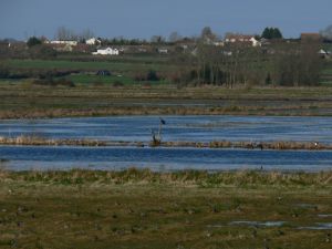
The character area incorporates the Alde/Ore and Butley Estuaries, Orfordness and Shingle Street and the towns of Aldeburgh and Orford. It is predominantly characterised by its status as a protected area but also as a recreational and tourist destination. The estuaries have a number of designations including Special Protection Area (SPA), RAMSAR, and Special Area of Conservation (SAC), and support diverse range of benthic communities. Shingle Street is an SSSI due to rare flora and Orfordness as a whole is the second largest vegetated shingle structure in UK, home to rare undisturbed vegetation communities and nationally important breeding tern populations. It is currently a national nature reserve, owned by the National Trust.
The Alde/Ore estuary is strongly constrained by man and is home to around 37% of entire country's saltmarsh. The river is divided into a number of named reaches including 'Troublesome Reach and 'Colliers Reach', the latter hinting at its history as a coal trading area. In contrast the Butley estuary is much smaller than others in the area.
Orfordness is separated from Orford beach by the River Ore. It was created by the action of the North Sea meeting the coast at an oblique angle, pushing silt and shingle in a southerly direction until it reaches the mouth of the River Ore where it is slowed by contrary currents and redeposited. The development of the spit is largely related to the estuaries. The spit is a relic shingle accumulation and is actively moving through a combination of erosion and deposition (Defra 2002). It is significant for its high educational and research value (English Nature 1997).
Aldeburgh is a popular upmarket seaside resort and small fishing village. Modern Orford is a tranquil retreat for visitors. Recreational attractions visited from these centres also include Havergate Island, an RSPB sanctuary in the River Ore famed for its avocets and Snape Maltings. The latter is a dedicated tourist centre and concert hall which hosts most of the famous Aldeburgh festival.
The offshore region of the character area incorporates the recreational zones immediately adjacent to the coast of Orfordness and Aldeburgh, including part of Hollesley Bay (see Hollesley Bay character area). Due to its proximity to the coast the depth in the area does not exceed 10 m and is not used for shipping, however the southern half of the offshore region is subject to Harwich Haven regulations and traffic separation and is covered by Vessel Traffic Services (VTS). It is subject to cautionary status due to submarine cables and high speed craft. The northern region falls under the jurisdiction of Great Yarmouth Port Operations, warning of changing depths and submarine cables and pipelines.
Commercial fishing is important to this area and small fleets exist at Aldeburgh and Orford, catching cod, sole and roker, in addition to lobster potting (ESFJC 2005). Recreational sea fishing is popular in the Rivers Alde and Ore, and from Orford lighthouse and Shingle Street.
Other characteristics of the area include reclaimed land to the east of Orfordness. An area of 'sandlings' (part of a once unbroken heath in this region) is also present. A secondary Royal Yacht Association (RYA) route runs into the Ore.
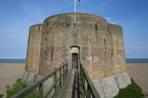
Caption: Aldeburgh martello tower entrance
Photo Courtesy: Oxford Archaeology
Historic Character and archaeological potential
Settlement evidence from the coastal region of the character area includes Neolithic flint, a Bronze Age burial and evidence of Roman salt working on the banks of the Alde. The character area was important from the Anglo-Saxon period and Aldeburgh was a settlement at this time, the name meaning 'Old fort'. The town's Moot Hall has roots in the Anglo-Saxon period. Anglo-Saxon cemeteries have been excavated at Burrow Hill, overlooking the Butley estuary and at Snape, the latter included a boat burial. Iken monastery was established on a promontory of the Alde river by St Botolph in the 7th century.
Orford castle was constructed overlooking the coast in 1173 by Henry II. At this time Orfordness had not grown to its current extent, which had occurred by 1800. The castle was granted to Robert Ufford in 1336 (Edwards 1991, 70) and has been used as navigation mark ever since.
The coast in the character area was an important trading centre in the Middle Ages with centres at Orford and Aldeburgh, exporting wool and importing cargo such as wine. Orford provided ships for Edward III in his battles against France and Aldeburgh had a thriving shipbuilding industry. In the 16th century the original port at Aldeburgh declined as a result of increasing ship size and silting of the river. The port was moved south to Slaughden. This remained a busy harbour until the 19th century, with coal brigs stopping off and barges exporting grain, malt and bricks. Latterly passenger services operated to Ipswich and London and a fertiliser industry grew up through coprolite extraction.
The fishing industry has also been significant in this area with herring and sprat the backbone of the industry. Maps from 1588 show fishing equipment and boats on the beach at Aldeburgh (Wheatley 1990, 68). In 1883 Aldeburgh had the largest fishing fleet of any beach landing in East Anglia (Edwards 1991, 85). In the 18th and 19th centuries cod smacks sailed from Aldeburgh to Norwegian waters (Edwards 1991, 90)
In the offshore area six known wrecks are recorded but no details of these are known. Onshore the Martello tower (see link) at Aldeburgh is a scheduled ancient monument in a unique quatrefoil layout. A number of listed buildings exist, in addition to Orford lighthouse (see link). A collection of military structures still stand on Orfordness which was taken over by the military from 1913 through to the 1970s (see link). These include anti-aircraft guns and monitoring posts.
Overall the potential for coastal and shipwreck archaeology is quite high. In addition the area has potential to contain submerged prehistoric landscapes, features or artefacts, particularly considering its estuaries and location in the area likely to have been coastal for thousands of years.
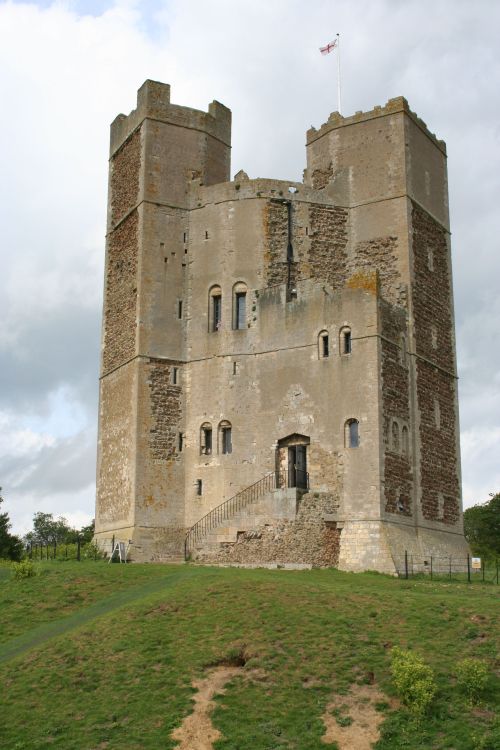
Caption: View of Orford Castle
Photo Courtesy: Oxford Archaeology
Character perceptions
The character area is well known for being an upmarket area of the Suffolk Coast with small traditional fishing villages, rather than commercial resorts. It is famous for highbrow events such as the Aldeburgh festival. This attitude is exemplified by The Scallop (see link).
The area has a rich maritime history which is seen all around. In addition it is known world-wide for the secret of Orfordness as a military base (see link). Recently suggestions have been made that the ness was the setting for a failed German invasion, with bodies washed up on the beach, though this is generally believed to be a myth.
Bibliography
Department for Environment Food and Rural Affairs, 2002, Suffolk Coast and Estuaries Coastal Habitat Management Plan Final Report. Defra
Eastern Sea Fisheries Joint Committee Annual Report 2005, 2005, Sea Fisheries Joint Committee
Edwards, R., 1991, The Suffolk Coast. Terence Dalton Ltd
English Nature, 1997, Suffolk Coast Maritime Natural Area Profile. English Nature
Jennings, P., 2006, Haunted Suffolk. Tempus
Wheatley, K., 1990, National Maritime Museum Guide to Maritime Britain. Webb & Bower
Trinity House. Available at:http://www.trinityhouse.co.uk/interactive/gallery/orfordness.html (15/03/2007)
Wikipedia. Available at: http://en.wikipedia.org (15/03/2007)
