England's Historic Seascapes: Southwold to Clacton
Oxford Archaeology (South), 2007. https://doi.org/10.5284/1000277. How to cite using this DOI
Data copyright © Historic England unless otherwise stated
This work is licensed under the ADS Terms of Use and Access.
Primary contact
Oxford Archaeology (South)
Janus House
Osney Mead
Oxford
OX2 0ES
UK
Tel: 01865 263800
Fax: 01865 793496
Resource identifiers
- ADS Collection: 746
- ALSF Project Number: 4729
- DOI:https://doi.org/10.5284/1000277
- How to cite using this DOI
England's Historic Seascapes:
Southwold to Clacton
ALSF Project Number 4729
Oxford Archaeology, 2007
Dunwich Bay
Primary Subcharacter Type:
Lost Settlement

Main Character / current form and use
The Dunwich Bay character area is located in the northernmost part of the study area parallel to the Southwold Area for a distance of c 13.5 km. Its predominant characteristic is its historical importance as the location of both the lost settlement of Dunwich and the Dunwich Bank shipwreck (see link) which is protected under the Protection of Wrecks Act 1973. It also incorporates the features of Dunwich Bank and Minsmere Haven.
The area comes under the jurisdiction of Great Yarmouth Port Operations and is a precautionary area due to submarine cables and changing depths, though the character area is too close to the shore to be used by commercial shipping. In general the depth of the area is within the range of 2 to 15 m, gradually decreasing close to the shoreline, though in places depth decreases further. Depth over Dunwich bank is 2-5 m. The underlying geology of the area is gravely muddy sand. The tidal range in the character area is within the range of 2-3m at Mean Spring Tide (DTI 2004).
A secondary Royal Yacht Association (RYA) route runs through the area parallel with the shore. The area is also a potential recreational dive site.
Historic Character and archaeological potential
The historic character and archaeology of the character area are highly significant on a national level in terms of the lost settlement of Dunwich, the Dunwich Bank wreck (see link) and the Battle of Sole Bay (see link).
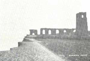
Dunwich was established in the Anglo-Saxon period and became East Anglia�s premier port in the Norman period (Wheatley 1990; Blair 1990). The Domesday Book recorded in 1086 that the settlement had three churches and a population of 3000 but that land was already being lost to the sea, by the 13th century this had increased to eight parish churches, several friaries, a town wall and a market place (Williamson 2006, 115). In 1286 a storm swept much of the town into the sea, and partially silted up the harbour. This led to a decline in trade and maintenance of sea defences was abandoned. In 1326 a second storm completely cut the harbour off from the sea and by 1350 more than 400 houses, shops, churches and windmills had been destroyed (ibid). The town was destroyed economically and much more has been lost to the sea down to the present day. The town declined to a small village, but still retained the right to send two Members to Parliament, becoming a rotten borough until the Reform Act of 1832. Local diver and historian Stuart Bacon has been diving the submerged site for many years and has discovered a number of churches illustrating the prosperity of the town, as well as possible remains of a shipbuilding industry.
The character area contains one very important shipwreck site, the Dunwich Bank site (see link) which marks the remains of an un-named 16th or 17th century armed merchant vessel or possibly a rare example of an early military transport vessel A total of eight other wrecks are known within the character area, including that of HMS Harvest Gleaner, which was sunk by German aircraft during the Second World War.
Character perceptions
Dunwich today is a small, scenic coastal village. However, much of the character of the area derives from its history as a formerly important town. It retains a great deal of national and regional archaeological and historical importance due to the remains of the town lying beneath the sea, as well as the wrecks off shore and its connection with the Battle of Solebay. There is a local legend that during stormy weather the church bells of the lost churches can still be heard. Local sailors and fishermen will not put to sea when the bells are heard as it is a sure sign of a coming storm.
The area of Dunwich which has been lost to the sea is not protected and is dived regularly by a group of local divers.
Bibiliography
Blair, A., 1990, Suffolk Coast. Norfolk: Anglian Landscapes
DTI, 2004, Mean Spring Tidal Range: Atlas of UK Marine Renewable Energy Resources. Department of Trade and Industry, 2004
Wheatley, K., 1990, National Maritime Museum Guide to Maritime Britain. Webb & Bower
Williamson, T., 2006, England's Landscape: East Anglia. English Heritage
English Heritage, 2007, Dunwich Bank. Available at: http://stage.english-heritage.org.uk/server/show/ConWebDoc.6561 (15/03/2007)
Wikipedia. Available at: http://en.wikipedia.org/wiki/Main_Page (07/03/2007)


