
England's Historic Seascapes: Southwold to Clacton
Oxford Archaeology (South), 2007. https://doi.org/10.5284/1000277. How to cite using this DOI
Data copyright © Historic England unless otherwise stated
This work is licensed under the ADS Terms of Use and Access.


Primary contact
Oxford Archaeology (South)
Janus House
Osney Mead
Oxford
OX2 0ES
UK
Tel: 01865 263800
Fax: 01865 793496
Resource identifiers
- ADS Collection: 746
- ALSF Project Number: 4729
- DOI:https://doi.org/10.5284/1000277
- How to cite using this DOI
England's Historic Seascapes:
Southwold to Clacton
ALSF Project Number 4729
Oxford Archaeology, 2007
Inner Gabbard East
Primary Subcharacter Type:
Dredging (aggregates)
Main Character / current form and use
The Inner Gabbard East area is predominantly characterised as a shipping area with relatively few other characteristic features. The area is bordered to the west by the Sunk Precautionary Area and to the east by the Gabbard and Galloper areas and is therefore within an area of dense navigational activity. The type of vessel known to transit the area include bulk and cargo vessels, ferries, tankers and gas carriers. A total of three different shipping routes appear to cross the area, two heading approximately SW-NE around East Anglia and one SSE-NNW to the continent.
The northern part of the area comes within the jurisdiction of the Harwich regulatory system. It is subject to restrictions concerning high-speed craft, submarine cables and traffic separation and is covered by Vessel Traffic Services (VTS). The southern part of the area is not within the jurisdiction of Harwich but is covered by VTS and subject to restrictions of high-speed craft, submarine cables, changing depths and draft restrictions.
A number of leisure sailing routes enter the area from the east, continuing onto the continent. The area is also a potential recreational dive site.
Overall, the depth of the area falls within the range of 30-50 m, though in places this decreases to as little as 15 m. The deepest areas fall within a pattern of troughs running approximately north-south along the character area. The tidal range in the area varies from 2 m to 3.1 m, with a predominantly NNE-SSW flow (http://www.portoffelixstowe.co.uk). The overlying geology is predominantly gravel.
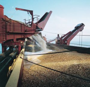
A small dredging area, approximately 4-km x 1km (Inner Gabbard) lies above one of the shallower parts of the character area, leased by Hanson Aggregates. Dredging activity is related to market demand, therefore activity can be sporadic and difficult to predict (Rogers 1997). This can affect fishing activity as actively dredged areas are temporarily closed to commercial fishing.
As a result of the proximity of the area to the haven ports and its depth, a small dumping ground is located to the west of the area. This is used to dump spoil from annual maintenance dredging at Harwich Harbour.
Historic Character and archaeological potential
Little is known about the historic character of this area although its intermittently shallow nature was marked on the Admiralty chart of 1905. A total of 16 known shipwrecks are located in the area, ten of which are considered dangerous. Five of the wrecks can be named as Harriet, Nico, Hebe, Khartoum and Paullette. These vessels were known to have been mined and sunk in the area and most represent continental passages.
The Albert Close fishing chart of 1953 records that this area was good sole ground in the summer.
In addition to it�s shipwreck potential the area has potential to contain submerged prehistoric landscapes, features or artefacts, having been dry land prior to 8000 BP. However, no investigation work is known to have been done in this area.
Character perceptions
The Inner Gabbard East area is known to the shipping community as a continental and national sea route and also for its dredging and dumping grounds. Presumably the area was chosen for such activities due to its low use and significance. As an area of open sea the area is unlikely to be known by local land-based communities.
Bibliography
Rogers, S. I., 1997, A review of closed areas in the United Kingdom Exclusive Economic Zone. CEFAS Science Series Technical Report No. 106
UKHO, 1953, Close�s Fishermen�s Chart of the North Sea United Kingdom Hydrographic Office
Port of Felixstowe. Available at: http://www.portoffelixstowe.co.uk (6/03/2007)
Wikipedia. Available at: http://en.wikipedia.org (15/03/2007)
