
England's Historic Seascapes: Southwold to Clacton
Oxford Archaeology (South), 2007. https://doi.org/10.5284/1000277. How to cite using this DOI
Data copyright © Historic England unless otherwise stated
This work is licensed under the ADS Terms of Use and Access.


Primary contact
Oxford Archaeology (South)
Janus House
Osney Mead
Oxford
OX2 0ES
UK
Tel: 01865 263800
Fax: 01865 793496
Resource identifiers
- ADS Collection: 746
- ALSF Project Number: 4729
- DOI:https://doi.org/10.5284/1000277
- How to cite using this DOI
England's Historic Seascapes:
Southwold to Clacton
ALSF Project Number 4729
Oxford Archaeology, 2007
Southwold Area
Primary Subcharacter Type:
Seaside Leisure Area
Main Character / current form and use
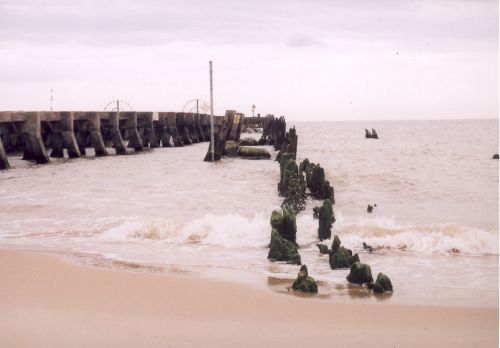
he Southwold area is characterised as a protected area and recreational and tourist haven. The character area incorporates the settlements of Southwold, Walberswick, Dunwich, Sizewell and Thorpe / Thorpeness as well as a large quantity of the protected Suffolk coast and heath area and the Blyth Estuary. Many of the settlements are traditional fishing villages and small towns and Southwold is particularly popular with tourists, incorporating sandy beaches and a pier.
Overall the area is part of the Suffolk Heritage Coast (see link) and within an Area of Outstanding Natural Beauty (AONB) The protected areas include the Minsmere to Walberswick marshes (SPA/RAMSAR), Leiston to Aldeburgh SSSI and the Sizewell marshes SSSI. The area supports a variety of habitats including grazing marsh, reedbed, swamp and open water with diverse plant and animal communities including nationally sparse species. The Minsmere levels RSPB nature reserve is home to breeding marsh harriers, one of Britain�s rarest birds of prey (Edwards 1991, 94). Westwood marshes is famous for freshwater reed beds used for thatching and cover for birds. The Blyth estuary, heavily constrained in places and large intertidal areas in others, supports nationally and sometimes internationally important populations of wintering wildfowl (English Nature 1997). The area is also characterised by its eroding shoreline, exemplified by the Norwich Crag cliffs at Dunwich.
This has been reduced in recent years by the Dunwich-Sizewell Bank but still continues at a high rate. Only the western fringes of the original Dunwich settlement survive (See Dunwich Bay character area). The cliffs are generally fronted by sand-shingle beaches, making the area a haven for visitors.
The offshore region of the character area comprises the immediate recreational waters off the coast and incorporate part of Dunwich Bay. Depths are generally up to 2 m deep but increase to 5 m in places. The area is too close to the coast for shipping traffic but is part of a wider area under the jurisdiction of Great Yarmouth Port Operations and subject to precautions for submarine cables and pipelines and changing depths. The tidal range in the character area is mainly within the range of 2-3 m at Mean Spring Tide (DTI 2004).
Commercial fishing has long been important to this region, though the industry is currently struggling. Fishing fleets launch from Sizewell and Aldeburgh. Techniques include drift netting for herring around Walberswick Bay and potting, catches include Sole, Skate and Rays. In addition, recreational sea fishing is popular off the beaches of Aldeburgh, Dunwich, Southwold, Sizewell, Thorpeness, Walberswick and Minsmere. Recreational diving boats are launched from Southwold, going up to 10 miles offshore as far south as Aldeburgh.
The character area also contains Sizewell power station (see Link). The station produces enough electricity for Norwich, Ipswich and Lowestoft (Edwards 1991, 92) but has been a controversial addition to the coastline.
Further developments are expected within the vicinity of Sizewell in the form of an electrical substation connected to the forthcoming Greater Gabbard windfarm (GGOW 2005)
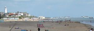
Caption: View of Southwold beach
Photo courtesy: Oxford Archaeology
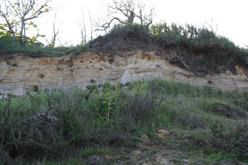
Caption: View of cliff erosion at Dunwich
Photo courtesy: Oxford Archaeology
Historic Character and archaeological potential
The coastal settlements mentioned above were once part of a prosperous maritime trade and fishing industry along the east coast. Southwold began life as a prehistoric settlement situated on an island (Wren 1976, 184) but was recorded as a thriving port in the Domesday Book of 1086 (Wheatley 1990, Blair 1990). Mud berths were constructed in Buss Creek to the north of the town and large ships were built there (Wren 1976, 184). Wreckage found in Buss Creek has recently been dated to AD970-1025 and AD890-155 (Bacon 1996). In the 16th century new quays, berths and slipways were constructed to handle the trade in wool (Edwards 1991, 104). Southwold also had a thriving herring fishery and in 1750 the Free British Herring Fishery headquarters were established in the town. Fishing remained important until the trade was killed by the First World War and ultimately the harbour silted up. By this time Southwold had been converted into a well-to-do seaside resort, fed by the introduction of the railway in 1879 which brought both holiday makers and freight (Edwards 1991, 103).
Walberswick was also a port, shipbuilding yard and fishing village in the Medieval period and was used by the Icelandic fishing fleets in the Tudor period (Wheatley 1990). Its prosperity was brought to an end when the sea breached the spit which protected the harbour. The present harbour was constructed by cutting through the shingle in 1590 (Edwards 1991 100). Other ports included Dunwich, as discussed in the Dunwich Bay character area and Blythburgh just to the north of the study area. Sizewell was an Anglo-Saxon settlement meaning Sisa�s well with a market from the 13th century and probably small port in the 16th century (Edwards 1991, 93)
Later coastal trade was important to the area including cargoes such as malt, corn, coal, coke and chalk (Edwards 1991, 100). The last seagoing ship reached Blythburgh bridge in 1870 before the estuary silted up. During this time smuggling became widespread in the character area and throughout the 18th century Sizewell gap was used to bring contraband ashore.
The prosperity of the region is shown by its soaring perpendicular churches (Williamson 2006) such as that at Blythburgh. The decline of the ports is illustrated by Walberswick church said to once have been as impressive as Blythburgh and Southwold but after the decline of the port it was demolished to build smaller one (Edwards 1991 103).
The land around the settlements has seen much reclamation throughout the centuries and elements of this still exist. Much of the Blyth was reclaimed after the 16th century but has been progressively abandoned since the 1930s. Minsmere levels was drained in the 19th century and allowed to flood again in 1940 to protect against enemy incursions.
Standing monuments within the character area include six 18 pound culverins located on Gunhill Cliff in Southwold, once used for defence (Edwards 1991 104). Southwold lighthouse, constructed in 1890 stands amongst the houses in the town and is visible from up to 17 miles out to sea. Scheduled monuments include the site of the Hospital of the Holy Trinity, chapel of St James hospital and Grey Friars priory at Dunwich, and the original site of Leiston Abbey.
This area of coast was well fortified in the World Wars with artillery recorded in 1941 at Southwold, Dunwich, Minsmere, Sizewell and Aldeburgh (Foynes 1994). A number of monuments dating to this period survive including gun sites, hideouts, anti-tank cubes, pillboxes, anti-aircraft batteries and gun emplacements.
Offshore, only one wreck is recorded, probably as a result of proximity to the coast. However scattered finds on shore date back to the Palaeolithic, Mesolithic and Neolithic indicating high potential for submerged prehistoric landscapes, features or artefacts, having been dry land prior to 8000 BP, particularly considering the location of the area close to the present day coastline in an area which may have been coastal for thousands of years. Samples taken from the Blyth in recent years indicate Regressive periods in 6750-6500 BP and 4500 - 4300BP which may have impacted on settlement patterns.
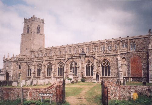
Caption: View of Blythborough church
Photo courtesy: Oxford Archaeology
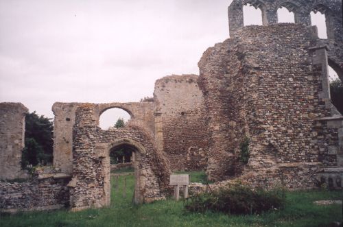
Caption: View of Walberswick church ruins
Photo courtesy: Oxford Archaeology
Character perceptions
This character are is well known in the local and national consciousness for a number of reasons. Southwold has a reputation as a very well-to-do seaside town and is frequented by enormous amounts of tourists every year. It is famous today for the Adnams brewery (see link), once equally famous as the Sole Bay brewery. The character of the area is illustrated by the ferry across the Blyth from Southwold to Walberswick which is the oldest surviving rowed ferry in the eastern counties (Edwards 1991 103).
However the area has become well-known recently as the location of the Sizewell nuclear power station, (see link), a controversial addition to the coastline and a subject of split opinions.
More traditionally, it is the heartland of the legend of 'Black Shuck', a large black dog with one central eye, believed to roam the East Anglian coastline. In 1577 the dog is said to have ran amok amongst congregation of Blythburgh church, killing two people (Edwards 1991 102).
Bibliography
Bacon, S. R., 1996, Southwold, Stuart Bacon
Blair, A., 1990, Suffolk Coast. Norfolk: Anglian Landscapes
DTI 2004. Department of Trade and Industry, 2004, Mean Spring Tidal Range: Atlas of UK Marine Renewable Energy Resources. Department of Trade and Industry 2004.
Edwards, R., 1991, The Suffolk Coast. Terence Dalton Ltd
English Nature, 1997, Suffolk Coast Maritime Natural Area Profile. English Nature
Foynes, J. P., 1994, Battle of the East Coast (1939-1945). J. P. Foynes
GGOW 2005. Greater Gabbard Offshore Winds Ltd, 2005, Wind Farm Non-Technical Summary. Greater Gabbard Offshore Winds Ltd.
Wheatley, K., 1990, National Maritime Museum Guide to Maritime Britain. Webb & Bower
Wren, W. J., 1976, Ports of the Eastern Counties: The Development of Harbours on the Coast of the Eastern Counties From Boston in Lincolnshire to Rochford in Essex. Dalton
Wikipedia. Available at: http://en.wikipedia.org (15/03/2007)
