England's Historic Seascapes: Southwold to Clacton

Oxford Archaeology (South), 2007. https://doi.org/10.5284/1000277. How to cite using this DOI

Digital Object Identifiers

Digital Object Identifiers (DOIs) are persistent identifiers which can be used to consistently and accurately reference digital objects and/or content. The DOIs provide a way for the ADS resources to be cited in a similar fashion to traditional scholarly materials. More information on DOIs at the ADS can be found on our help page.

Citing this DOI

The updated Crossref DOI Display guidelines recommend that DOIs should be displayed in the following format:

https://doi.org/10.5284/1000277
Sample Citation for this DOI

Oxford Archaeology (South) (2007) England's Historic Seascapes: Southwold to Clacton [data-set]. York: Archaeology Data Service [distributor] https://doi.org/10.5284/1000277

Data copyright © Historic England unless otherwise stated

This work is licensed under the ADS Terms of Use and Access.
Creative Commons License


Aggregates Levy Sustainability Fund logo
Historic England logo

Primary contact

Oxford Archaeology (South)
Janus House
Osney Mead
Oxford
OX2 0ES
UK
Tel: 01865 263800
Fax: 01865 793496

Send e-mail enquiry

Resource identifiers

Digital Object Identifiers

Digital Object Identifiers (DOIs) are persistent identifiers which can be used to consistently and accurately reference digital objects and/or content. The DOIs provide a way for the ADS resources to be cited in a similar fashion to traditional scholarly materials. More information on DOIs at the ADS can be found on our help page.

Citing this DOI

The updated Crossref DOI Display guidelines recommend that DOIs should be displayed in the following format:

https://doi.org/10.5284/1000277
Sample Citation for this DOI

Oxford Archaeology (South) (2007) England's Historic Seascapes: Southwold to Clacton [data-set]. York: Archaeology Data Service [distributor] https://doi.org/10.5284/1000277

Stour Estuary

Holbrook Bay Fish Traps

The fish traps located at Holbrook Bay are very similar to those recorded in the Blackwater estuary in Essex which were dated 7th - 10th century (Suffolk County Council 2006). The fish traps survive as rows of posts with patches of wattle work, constructed in V-shapes. Baskets or nets were placed at the point of the 'V' and fish were funnelled down to be caught as the tide went out. Wattle walkways along the walls allowed access at low tide to retrieve the fish and repair the walls (ibid).

Fish trap

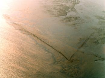
Caption: A fish trap from the air

Photo courtesy: English Heritage

Fish trap

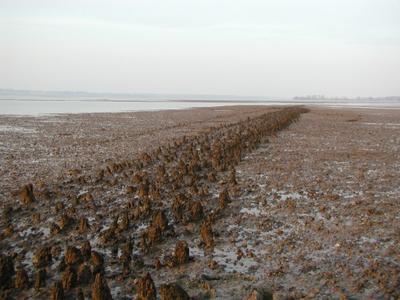
Caption: A fish trap at Holbrook Bay

Photo courtesy: English Heritage


ADS logo
Data Org logo
University of York logo