
England's Historic Seascapes: Withernsea to Skegness
Museum of London Archaeology, 2010. https://doi.org/10.5284/1000104. How to cite using this DOI
Data copyright © Historic England unless otherwise stated
This work is licensed under the ADS Terms of Use and Access.


Primary contact
David
Bowsher
Director of Research
Museum of London Archaeology
Mortimer Wheeler House
46 Eagle Wharf Road
London
N1 7ED
UK
Tel: 020 7410 2285
Resource identifiers
- ADS Collection: 935
- ALSF Project Number: 4730
- DOI:https://doi.org/10.5284/1000104
- How to cite using this DOI
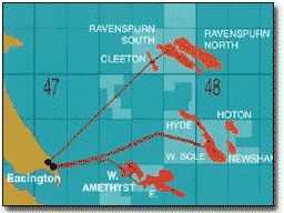
Amethyst West Character Area
Present Day Form
The Amethyst West offshore character area is situated in the northern central section of the study area off the east coast of East Yorkshire. The geology comprises Chalk bedrock overlain by glacial till (clay, sand and gravel debris deposited from ice sheets) known as the Boulders Bank Formation. The water depth across the area varies between 18m and 22m and the maximum tidal range is 2-3m. The Silver Pit palaeochannel lies immediately to the east of Amethyst West.
Sea Use: Present
The Amethyst West character is dominated by gas related industry. The Amethyst West field was discovered in 1970 and started production in 1991. With reserves of 21 billion cubic metres of gas and a peak production of 1 billion cubic metres of gas per year it is one of the southern North Sea's larger hydrocarbon fields. It has permanent installations on the seabed and free standing rigs. The field is connected to the Easington Gas Terminal in East Yorkshire by direct pipeline.
Fishing activity in the area is limited by the rough nature of the sea bed and the gas industry infrastructure. Commercial shipping crosses the area on a regular basis.
Sea Use: Past
The Amethyst West character area has been shaped by thousands of years of dynamic sea level changes and erosion and deposition. The relatively shallow nature of the sea bed means that the area was dry land almost certainly in the Upper Palaeolithic and Mesolithic.
Marine traffic would have crossed this area on a regular basis from the Roman period onwards utilising the North Sea route from the Humber ports. Fishing activity would have been carried out in the area from the medieval period onwards. The Close's Fisherman's Chart (UKHO 1953) describes the area as mostly foul and very foul off the Humber.
Archaeological Potential
The Amethyst West character area has potential for the presence of drowned land surfaces resulting from the fact that sea level has fluctuated between -120 metres and +10 metres over the past 500,000 years. From the period 500,000 BP to 22,000 BP (before present), human population levels were low, and little more than stray finds may be expected, although these may still be of considerable archaeological importance.
From 22,000 BP to 2100 BP parts of the North Sea were dry land and human population levels were higher, especially in the Mesolithic age. Finds dating to the Mesolithic have been found to a depth of 40m so any area of sea bed above that has potential for habitation. Inundation of the North Sea landscapes occurred between 10,000 and 6,000 BP and the most likely evidence for human occupation would be, therefore, Mesolithic in date.
Earlier Palaeolithic occupation is less likely to be found and later Neolithic occupation is likely to have been limited to the inshore and very highest of the banks and shoals such as the Dogger Bank. The area's position adjacent to the Silver Pit channel makes it a prime Mesolithic habitation area. Consequently, there is some potential for surviving evidence of human activity within the area.
Over the last 6000 years (if not more), humans have used sea faring vessels and this area and wrecks and related material that may lie on the sea floor or be buried beneath the sea floor. UKHO and NMR data show a total of 15 known wrecks in this area, 6 unnamed and 9 named. Most of these vessels are World War Two losses and reflect the large concentration of wrecks found in the sea off the Humber approaches and the importance of Hull and the Humber ports in the war effort. Typical of the losses in this character area is the 'SS Royston' a 2,722 ton cargo ship carrying coal from Hartlepool to London damaged by enemy aircraft and sank 'off Spun Point' 4th May 1941.
Character Perceptions
The area is perceived as an important industrial area as it contains the Amethyst West production field.
References
BP North Sea Infrastructure: Amethyst Platform. Web: www.bpnsi.com
Close's Fisherman's Chart (UKHO 1953)
Fisheries Sensitivity Maps in British Waters (MAFF 1989)
Scandoil, North Sea Oil and Gas production Fields (Scandoil Oil and Gas Magazine online)
Images
Amethyst-Web
Web:http://www.bpnsi.com/index.asp?id=7369643D312669643D323234
