
England's Historic Seascapes: Withernsea to Skegness
Museum of London Archaeology, 2010. https://doi.org/10.5284/1000104. How to cite using this DOI
Data copyright © Historic England unless otherwise stated
This work is licensed under the ADS Terms of Use and Access.


Primary contact
David
Bowsher
Director of Research
Museum of London Archaeology
Mortimer Wheeler House
46 Eagle Wharf Road
London
N1 7ED
UK
Tel: 020 7410 2285
Resource identifiers
- ADS Collection: 935
- ALSF Project Number: 4730
- DOI:https://doi.org/10.5284/1000104
- How to cite using this DOI
East Halton to Immingham Coast Character Area
Present Day Form
This character area is located in the north-western extent of the study area on the south side of the Humber Estuary in the parish of North Lincolnshire. The area is entirely land based but has historically influenced the local seascape to a significant degree. The character area is bounded to the east by the Yorkshire Wolds and the northern Lincolnshire Edge and to the west by the southern part of the Yorkshire magnesian limestone ridge. In the north it merges with the slightly more undulating Vale of York close to the Escrick moraine and to the south it merges into the Trent Vale. The underlying geology in the character area consists of the upper cretaceous chalks of the Lincolnshire Wolds.
Sea Use: Present
The area has a strong coastal industry character and contains the industrial and chemical docks and works at Killingholme and the industrial docks of Immingham and Grimsby. The area has historically been associated with fishing on a large scale and although fishing is still carried out it is on a much smaller scale. The industrial petrochemical and cargo uses of the area are now far more prominent.
The villages of North Killingholme and South Killingholme are the site of two oil refineries, the Humber Refinery and Lindsey Oil Refiner. A liquid petroleum gas storage facility is also situated in the area.
The docks at Killingholme and Immingham are fast expanding ports, handling RORO ferries from Belgium and Hoek van Holland, as well as car imports from mainland Europe and Korea.
Grimsby has strong connections with the sea fishing industry, which oce brought wealth and prosperity to the town. At its peak in the 1950s, it was the largest and busiest fishing port in the world. Although it has declined since, many of the food manufacturing places that grew up in the area, as a result of the fishing industry, are still active and continue to characterise the area.
Killingholme also has disused WWII structures and an airfield. It was formerly the home of RAF 550 Squadron who were credited with opening the D-day attack in 1944.
Sea Use: Past
All the settlements in the area date from at least the medieval period but have now become dominated by modern heavy industry. The original settlement and growth of the area is related to the fishing industry and trade resulting from activity at the docks.
Grimsby was founded by the Danes in the 9th century AD. There is also evidence of an earlier small Roman town in the area. Grimsby had a natural haven, which flowed into the Humber and would have provided an ideal harbour for incoming ships.
During the 12th century Grimsby developed into a fishing and trading port but by the 15th century the haven had begun to silt up, preventing ships in the Humber from docking. As a result, Grimsby entered a long period of decline which lasted until the late 18th century.
In the early 19th century the haven was deepened and enlarged and the port boomed as a result importing iron, timber, wheat, hemp and flax. New docks were constructed in order to cope with the expansion. The arrival of the railway in 1848 made it easier to transport goods to and from the port.
Grimbsy has various conservation areas that preserve elements of the historic maritime character of the town. These are the Great Cotes area of Grimsby, which was once a distinct fishing village and was later subsumed into the fast expanding Grimsby. There is also the Wellow area of Grimsby which preserves elements of the expanding post-medieval dock areas. The central area of Grimsby is also preserved in a conservation area and retains the medieval street plan and many of the buildings that relate to the growth of the town as a fishing town.
There are also a number of much smaller villages that have historic connections with previous saltmaking and fishing industries in the area including East Halton, an 11th century village now separated from the sea, and Stallingborough which was associated with salt making and was once connected with the sea by haven and channel (now silted up). The settlement at Healing was also a former fishing village.
Archaeological Potential
The area has potential for archaeological survival from the prehistoric to post medieval periods. In particular archaeological deposits will survive that relate to coastal salt making industries and fishing industries.
The area also contains a WWII battery and disused WWII airfield so has potential for WWII archaeology.
Character Perceptions
It is perceived as being an important area for coastal industry, especially docks and petrochemicals.
References
Lambert T, a brief history of Grimsby. Web: www.localhistories.org/grimsby.html
Historical Grimsby, A thousand years of history and famous figures from Grimsby in Lincolnshire. www.visitoruk.com/grimsby/history/timeline.htm.
www.northlincs.gov.uk/NorthLincs/Leisure/libraries/localstudies/localhistorypacks/EastHalton.htm
Images
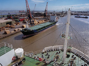
Humber sea terminal
Web: http://www.geograph.org.uk/photo/74796
