
England's Historic Seascapes: Withernsea to Skegness
Museum of London Archaeology, 2010. https://doi.org/10.5284/1000104. How to cite using this DOI
Data copyright © Historic England unless otherwise stated
This work is licensed under the ADS Terms of Use and Access.


Primary contact
David
Bowsher
Director of Research
Museum of London Archaeology
Mortimer Wheeler House
46 Eagle Wharf Road
London
N1 7ED
UK
Tel: 020 7410 2285
Resource identifiers
- ADS Collection: 935
- ALSF Project Number: 4730
- DOI:https://doi.org/10.5284/1000104
- How to cite using this DOI
Haile Sand Character Area
Present Day Form
Haile Sand character area is located in the western part of the study area, next to the Donna Nook character area and adjacent to the Cleethorpes to Mablethorpe coast. The area contains part of the Cleethorpes to Mablethorpe shoreline and also part of the open sea adjacent to this shoreline.
The geology of the area is a wave cut platform of Cretaceous Chalk overlain by glacial till (clay, sand and gravel debris deposited from ice sheets) called the Upper Marsh Till along with some early Holocene deposits of peat known as the Huttoft Beds. The Huttoft Beds formed in the hollows of the Mesolithic land surface which developed on the Upper Marsh Till. The early land surface was inundated by a marine transgression leaving a clay deposit known as the Ingoldmells Beds. The Beds have been dated to periods between the Bronze Age and the Roman period and represent localised marine flooding over the area as the sea level rose.
The action of the sea in this area causes accretion rather than the erosion seen on beaches further to the south between Mablethorpe and Skegness. As a result the coast is characterised by wide sandy beaches, muddy areas, dunes and salt marsh where mariculture activities take place along with recreational activities. By contrast the beaches further to the south are regularly replenished and used almost solely for recreation purposes. The actions of the sea have strongly influenced patterns of historic land/sea use in the area.
Sea Use: Present
The dominant characteristic of the area is coastal industry because two active historic channels pass across the mud flats and the area contains shellfish and samphire beds. In addition to this, the area contains large areas of mudflats at low tide and two named wreck clusters, posing a hazard to navigation. The military practice area that largely occupies the adjacent Donna Nook character area also extends into Haile Sand.
The close proximity of the area to the Cleethorpes to Mablethorpe coastline means that the areas are closely connected. The two active channels connect this character area to the havens at Saltfleetby and Somercotes (contained in character area Cleethorpes to Mablethorpe coastline). Fishing vessels leave for the open sea via these channels.
The area contains many drying areas that present a hazard to navigation and so dredging is regularly carried out, especially in the area of Saltfleetby. The Haile Sand character area contains Haile Sand Fort, one of two large fortifications in the mouth of the Humber estuary. Both forts were built in 1914 to protect the entrance to the estuary. Haile Sand Fort is located around the low water mark between Cleethorpes and Humberston on the Lincolnshire coast. Bull Sand Fort is situated in the Outer Humber Estuary character area.
Sea Use: Past
The coastline has changed considerably in this area over the centuries. The medieval coastline was originally situated much further to the west (see Cleethorpes to Mablethorpe coastline character area description), which means that this area was located in deeper water in recent centuries.
It is not documented exactly how long the fishing and maritime activities have been carried out in the area but it is likely to have taken place for as long as human beings have occupied the area. These particular activities, therefore, have considerable time depth.
The Humber forts originally had a military use in protecting the mouth of the estuary. The forts both stand 18 meters (59 ft) above the water and have a diameter of 25 meters (82 ft). The forts took three years to build and provided accommodation for 200 soldiers. During World War II the forts remained as a deterrent and were regularly attacked by enemy aircraft. During this time netting was put up to prevent enemy submarines travelling up the estuary to Hull or Grimsby.
Archaeological Potential
The area has potential for the presence of drowned land surfaces resulting from the fact that sea level has fluctuated between -120 metres and +10 metres over the past 500,000 years. From the period 500,000 BP to 22,000 BP (before present), human population levels were low, and little more than stray finds may be expected, although these may still be of considerable archaeological importance.
From 22,000 BP to 2100 BP parts of the North Sea were dry land and human population levels were higher. Over the last 6000 years (if not more), humans have used sea faring vessels and so wrecks and related material lie buried in the intertidal area or be buried beneath the sea floor. Two wreck cluster sites are identified in the character area. Both date to the post-medieval period and are mainly schooners dating to the 1830s.
Character Perceptions
The area is important for mariculture industries and is a named location on navigation charts.
References
Brenchley O J, Rawson P F, 2006 The Geology of England and Wales 2nd edition
en.wikipedia.org/wiki/Humber_Forts
http://marinas.com/view/landmark/107_Haile_Sand_Fort_Lincolnshire_GB
Images
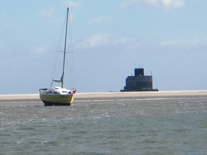
Haile Sand Fort
Web: www.rnli.org.uk/rnli_near_you/north/stations/CleethorpesNorthLincolnshire/gallery/station_image?nodeid=365895
