
England's Historic Seascapes: Withernsea to Skegness
Museum of London Archaeology, 2010. https://doi.org/10.5284/1000104. How to cite using this DOI
Data copyright © Historic England unless otherwise stated
This work is licensed under the ADS Terms of Use and Access.


Primary contact
David
Bowsher
Director of Research
Museum of London Archaeology
Mortimer Wheeler House
46 Eagle Wharf Road
London
N1 7ED
UK
Tel: 020 7410 2285
Resource identifiers
- ADS Collection: 935
- ALSF Project Number: 4730
- DOI:https://doi.org/10.5284/1000104
- How to cite using this DOI
Hull Coast Character Area
Present Day Form
The character area is situated in the north-western extent of the study area, on the north bank of the Inner Humber Estuary in the parish of East Riding of Yorkshire. The area includes the River Hull but apart from this is entirely land based. Hull has formed a pivotal role in shaping the character of the surrounding seascape and its range of influence, and vice versa, is literally huge. The area is entirely land based and is an essential part of the surrounding seascape. The Geology of the area is glacial moraine, chalk and boulder clay overlain by thick deposits of alluvium. Hull City itself is built on reclaimed salt marshes (University of Hull 1994). The character area falls within the Humberhead levels and is low lying.
Sea Use: Present
The area has a strong coastal industry character and is densely settled, containing the urban maritime City of Hull. The land is actively managed in order to maintain the land/sea boundary.
The City of Hull is an ancient settlement that was founded at the confluence of the River Hull and the Humber Estuary. The growth of Hull is directly related to the fishing industries which date back to the medieval periods. Although Hull retains its maritime character, it has changed and industry is no longer solely associated with fishing. The Estuary is still is busy shipping route but much of this is now associated with other cargoes, passenger ports and industry related to petrochemicals.
The maritime character of Hull is retained in its docks, some of which are still active as ports and cargo docks. For instance, the Albert and William Wright Docks were built in 1869 as a fish dock. Now it receives cargo vessels and ship repair industry is carried out there. Alexandra Dock opened in 1885 as a cargo dock and it is still used for this purpose today, as well as being a passenger dock. King George and Queen Elizabeth dock exports minerals such as coal, container traffic and scrap metal. It also has a passenger port. The old Humber dock was closed to shipping in 1969 and is now Hull Marina.
Other old docks have been converted into water features as part of residential dockside housing schemes or filled in and converted into public parks (ie St Andrews Dock and Queens Gardens, which used to be Queens Dock and Victoria Dock, now gardens). The old citadel area now houses the world famous Hull Aquarium.
The River Hull is an active channel that still has a commercial/industrial character. It is lined with warehouses and depots associated with processing incoming and outgoing cargoes. Parts of it are also used for local trout and salmon fishing at certain times in the year.
The village of Hessle is also included in the character area. The village grew up around the ancient ferry point to Barton but these days its haven is used as a scrap metal processing area and material is barged in and out from this point.
Sea Use: Past
Hull was originally an outlying part of the hamlet of Myton when, in the late 12th century, it was chosen by the monks of Meaux Abbey to develop as a new town which they named Wyke upon Hull after John Wyke, Archbishop of York. The locals called the settlement Hull, after the River, and the town went on to prosper due to its location on the Humber Estuary and the River Hull.
The port served as a base for Edward I during the First War of Scottish Independence and later developed into the foremost port on the east coast of England. It prospered by exporting wool and woollen cloth and importing wine. Hull also established commerce links with the Baltic ports as part of the Hanseatic League.
The fishing trade boomed in the mid 19th century and it was at this time that Hull received its numerous docks, most of which were constructed to capitalise on fishing. The boom in the fishing industry and related dock construction was also associated with the advent of the railways, which allowed fresh fish to be transported quickly all over the country. There was suddenly a wide market for fresh fish and this caused it to become more affordable, which also stimulated growth of the industry.
Whaling played a major role in the town's fortunes until the mid-19th century. The first whaling ships left the port of Hull in 1598, soon after the discovery of Greenland. The industry was thriving by the early nineteenth century after many recessions and revivals. During the years 1815-1825 Hull had 2,000 men employed in the trade and had over 60 whaling vessels making it the largest fleet in Britain.
The Albert and William Dock, St Andrews Dock, Humber Dock Princes dock, Queens dock, Victoria dock were all built specifically as fish docks. All of these have now been converted to other uses.
The City contains various conservation areas that have preserved much of Hull's medieval and later street patterns and many buildings that are related to 19th century growth as a fishing town.
The village of Hessle originated in the medieval period as a ferry point across the Humber.
Archaeological Potential
The area has a proven potential for the survival of archaeological remains from all periods. The area has a potential for buried ancient landscapes which lie under the peat. Since waterlogging inhibits the decomposition of organic remains, wetland areas form a rich archaeological resource.
Mesolithic and early Neolithic material was found close to the River Hull illustrating the importance of river systems to the people of the region. There is high potential for Mesolithic, early Neolithic and Bronze Age sites to survive in a well preserved state beneath alluvial sediments. The majority of finds have come from alluvial areas. At Wilfholme Landing, Watton Carrs, research in the 1980s produced seven split oak timbers of Bronze Age date of unknown function.
The area has also provided evidence for the production of Iron Age bronzes in Yorkshire and evidence from these sites indicates that there was interdependence between Iron Age activity in the wetland landscape of the upper Hull valley and that in the dryland landscape of the Yorkshire Wolds. Evidence for Roman riverside settlements was also discovered in the area.
Character Perceptions
Hull is perceived as an urban industrial and commercial settlement with strong maritime links. The economy of Hull was built on seafaring and although the fishing industry is in decline the city remains a very busy port, handling 13 million tonnes of cargo per year.
References
University of Hull, 1994, Humber Estuary and Coast, Institute of Estuarine and Coastal Studies, University of Hull, November 1994
The Humber Wetlands Project. Wetland Heritage of the Hull Valley. Wetland Archaeology and Environments Research Centre, Dept. of Geography, University of Hull
"History of Hull". Hull City Council 2007
Victoria County History, A History of the County of York East Riding Volume 1, 11-85
Web: www.hullcc.gov.uk/museumcollections
Images
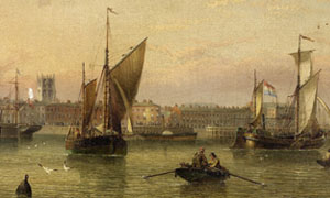
Detail from Redmore print
Web: www.hullcc.gov.uk/museumcollections/collections/theme.php?irn=158
