
England's Historic Seascapes: Withernsea to Skegness
Museum of London Archaeology, 2010. https://doi.org/10.5284/1000104. How to cite using this DOI
Data copyright © Historic England unless otherwise stated
This work is licensed under the ADS Terms of Use and Access.


Primary contact
David
Bowsher
Director of Research
Museum of London Archaeology
Mortimer Wheeler House
46 Eagle Wharf Road
London
N1 7ED
UK
Tel: 020 7410 2285
Resource identifiers
- ADS Collection: 935
- ALSF Project Number: 4730
- DOI:https://doi.org/10.5284/1000104
- How to cite using this DOI
Humber Estuary Mouth Character Area
Present Day Form
The character area is situated in the north-western extent of the study area and comprises the more seaward area of the Humber Estuary. The area is demarked by Haile Sands to the south and the Binks to the north. The area is entirely Estuarine and is the main access route into the River Humber. The Geology of the area is chalk and boulder clay overlain by deep deposits of alluvium.
The Humber Estuary is a tidal waterway that divides Lincolnshire and Yorkshire and flows into the North Sea. It is formed by the merging of the River Ouse and the River Trent. The Estuary is the second largest coastal plain estuary in the UK. It has a very large tidal range - the mean spring tidal range is 5.7m at Spurn, 7.4m at Saltend and 6.9m at Hessle (which is 45 miles inland).
Sea Use: Present
The Humber Estuary has 40,000 ship movements per year and is the UK's largest port complex (humberems.co.uk). The area is, therefore, dominated by characteristics associated with navigation. The tidal river estuary is a highly dynamic environment with lots of different channels and drying areas that present a continual hazard to navigation. As a result of the changing environment one of the major activities that takes place in the character area is maintenance dredging. This activity is carried out extensively on the approach to the major settlements along its route, such as at Hull and Grimsby and in the main Estuary approach in Bull Channel. There are set and demarcated dredged navigation routes in these areas.
The hazardous business of navigating the Estuary is well attested by the numerous wreck clusters, which often provide an additional hazard to ongoing navigation in themselves.
As well as being a major transport route the River is also a spawning ground for species like sole and a nursery for sprat, plaice and lemon sole, etc. Fishing for eel and whitefish takes place at certain times of the year in specific locations along both shores.
In addition to all the industry that takes place in the area, this part of the estuary falls within the Donna Nook military practice area
Sea Use: Past
The Humber Estuary was formed 10,000 years ago during the last ice age when the advancing glaciers buried the old coastline beneath a blanket of boulder clay (Hull University Press 1994). Prior to this the estuary mouth was much further to the west, where the Humber Bridge currently stands. The Estuary has been used as a transport route and fishing area since the prehistoric period, for example some of the earliest known wooden boats in Europe were discovered on the foreshore at North Ferriby (Van de Noort 2000, 167). Many of the surrounding ancient settlements on the Estuary banks accessed the Estuary and grew up because of the opportunities it offered for transport and fishing.
The estuary was largely unconfined until the 12th century, after which it became increasingly embanked. Land was reclaimed in the area and used for agricultural purposes (ibid).
Archaeological Potential
Due to the highly dynamic and constantly changing coastline in this area, the character area has potential for archaeology from all periods. The waterlogged environment means preservation of artefacts from earlier periods will be good.
Character Perceptions
The Humber Estuary Mouth is perceived as being a navigation channel and fishing area.
References
University of Hull, 1994 Humber Estuary and coast
Images
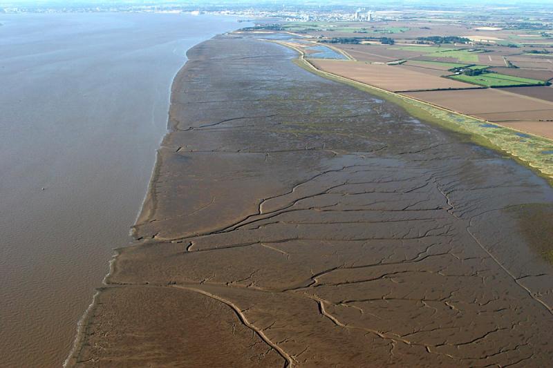
Mud flats along the Humber Estuary
Web: http://www.pbase.com/clements/image/50216514
