
England's Historic Seascapes: Withernsea to Skegness
Museum of London Archaeology, 2010. https://doi.org/10.5284/1000104. How to cite using this DOI
Data copyright © Historic England unless otherwise stated
This work is licensed under the ADS Terms of Use and Access.


Primary contact
David
Bowsher
Director of Research
Museum of London Archaeology
Mortimer Wheeler House
46 Eagle Wharf Road
London
N1 7ED
UK
Tel: 020 7410 2285
Resource identifiers
- ADS Collection: 935
- ALSF Project Number: 4730
- DOI:https://doi.org/10.5284/1000104
- How to cite using this DOI
Lynn Character Area
Present Day Form
The Lynn character area is situated at the southern end of the study area immediately offshore from the Skegness and Mablethorpe coastal waters character area. The geology of the area comprises chalk bedrock overlain by glacial till (clay, sand and gravel debris deposited from ice sheets) known as the Boulders Bank formation. The water depth across the area varies between 6m and 13m and the maximum tidal range is 6m. The seabed of the area consists of a shallow sloping thin bed of sand, gravel and shells.
Sea Use: Present
The character area contains a licensed area for an offshore wind farm. The proposed site for this extends over an area of 2.5 km by 4 km (1.35 nautical miles by 2.15 nautical miles) orientated approximately east-west. The shortest distance between any turbine and the nearest point on the coast is 5 km.
The principal fishing activity in the area is long-lining and some netting for cod, roker, sole and brill, trawling for white fish by beam trawlers, crab and lobster potting and shrimp fishing for brown and pink shrimp. The area is not the most intensively fished of the inshore area between the Humber and The Wash, but is locally important, particularly for smaller vessels and for vessels following the more mobile fisheries. The area has spawning areas of Dover sole and lemon sole and is within nursery areas used by lemon sole and plaice, but is offshore of the main Dover sole and cod nursery areas.
Sea Use: Past
The Lynn Character area has been shaped by thousands of years of dynamic sea level changes and erosion and deposition. The relatively shallow nature of the sea bed means that the area was dry land almost certainly in the Upper Palaeolithic, Mesolithic and probably in the Neolithic periods.
Marine traffic would have crossed this area on a regular basis from the Roman period onwards but especially in the medieval period when Wainfleet St Mary was a busy port. Its access to the sea gradually silted up and Wainfleet Haven was established nearer the coast to carry on the maritime trade. Continued silting and dune formation resulted in the last commercial vessels using the port in the1920's. Fishing activity would have been carried out in the area from the medieval period onwards.
Archaeological Potential
The Lynn character area has potential for the presence of drowned land surfaces resulting from the fact that sea level has fluctuated between -120 metres and +10 metres over the past 500,000 years. From the period 500,000 BP to 22,000 BP (before present), human population levels were low, and little more than stray finds may be expected, although these may still be of considerable archaeological importance.
From 22,000 BP to 2100 BP parts of the North Sea were dry land and human population levels were higher. The area's position adjacent to the Ouse/Nene palaeochannel makes it prime habitation site. Consequently, there is some potential for surviving evidence of human activity within the area. Over the last 6000 years (if not more), humans have used sea faring vessels and so wrecks and related material may lie on the sea floor or be buried beneath the sea floor.
Character Perceptions
Along the coast there are a number of seaside resorts at Skegness, Ingoldmells and Mablethorpe. The area is perceived as an inshore fishing ground and also as an immediate offshore area to an important recreational area around Skegness and the National Nature Reserve at Gibraltar Point.
References
http://www.amec.com/uploadfiles/LynnNTS.pdf Lynn offshore Wind Farm Non -Technical summary
BGS (British Geological Survey), 2001 North Sea Geology. Technical Report TR_008 for Strategic Environmental Assessment (SEA2)
Images
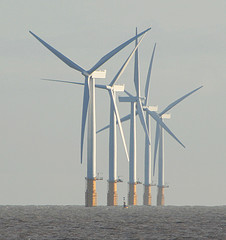
Lynn Windfarm
Web: www.flickr.com/photos/electropod/3087010838/
